Trail Walking Saint-Fargeau-Ponthierry - Saint Fargeau Ponthierry - Photo
 tracegps
tracegps

User

© OpenStreetMap contributors
Length
Length
11.2 km
Max alt
Max alt
92 m
Uphill gradient
Uphill gradient
116 m
Km-Effort
Km-Effort  
12.7 km
Min alt
Min alt
35 m
Downhill gradient
Downhill gradient
116 m
Boucle
Boucle
Yes
Creation date :
2014-12-10 00:00:00.0
Updated on :
2014-12-10 00:00:00.0

(1 Reviews)

Walking
Walking
3h00
Difficulty : Medium

Scan this QR Code to open this trail in the SityTrail application

FREE GPS app for hiking

Logo SityTrail SityTrail

IGN / Geographical institutes

Download SityTrail from the App Store Download SityTrail from Google Play

Logo SityTrail SityTrail World

The world is yours!

Download SityTrail from the App Store Download SityTrail from Google Play Download SityTrail on Huawei AppGallery

About

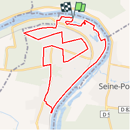
Trail Walking of 11.2 km to be discovered at Ile-de-France, Seine-et-Marne, Saint-Fargeau-Ponthierry. This trail is proposed by tracegps.

Description

Saint Fargeau Ponthierry Promenade de 11,5 km. à effectuer en flânant le long de la Seine, des lacs et près des belles demeures en sites privés. D’autres informations et photos sont disponibles ICI

Elevation profile

Photos

Positioning

Country:
France
Region :
Ile-de-France
Department/Province :
Seine-et-Marne
Municipality :
Saint-Fargeau-Ponthierry
Location:
Unknown
Start:(UTM)
465812 ; 5380057 (31U) N.

Comments

Please log in to post a review or rate the element


Trails nearby

Trail Walking Savigny-le-Temple - Entre Savigny-le-Temple et Seine-Port - Photo
Walking
DUGAEL

Walking

Very easy
(1)
Savigny-le-Temple, Ile-de-France, Seine-et-Marne, France
11 km | 12.8 km-effort
2h 59min
No
Trail Walking Cesson - JC 20   19.50 km  -  Cesson la Forêt, forêt de Bréviande - Photo
Walking

Walking

Difficult
(2)
Cesson, Ile-de-France, Seine-et-Marne, France
19.1 km | 21 km-effort
4h 48min
Yes
Trail Walking Cesson - 2020-09-30_18h09m29_JaINFIZemJ8 - Photo
Walking

Walking

Medium
(1)
Cesson, Ile-de-France, Seine-et-Marne, France
11.5 km | 13 km-effort
2h 56min
Yes
Trail Running Seine-Port - Fore?t de Rougeau et bords de Seine - Photo
Running
tracegps

Running

Very difficult
(2)
Seine-Port, Ile-de-France, Seine-et-Marne, France
28 km | 32 km-effort
3h 30min
No
Trail Walking Nandy - 2017-10-05-Cesson - Photo
Walking

Walking

Difficult
(1)
Nandy, Ile-de-France, Seine-et-Marne, France
21 km | 24 km-effort
5h 32min
Yes
Trail On foot Saint-Pierre-du-Perray - 2020-10-20_05h12m58_R2iIxMbsAX0 - Photo
On foot

On foot

Very easy
(1)
Saint-Pierre-du-Perray, Ile-de-France, Essonne, France
7.3 km | 7.9 km-effort
1h 47min
Yes
Trail Mountain bike Le Coudray-Montceaux - Le Coudray-Montceaux VTT - Photo
Mountain bike
godmer

Mountain bike

Very difficult
(1)
Le Coudray-Montceaux, Ile-de-France, Essonne, France
37 km | 43 km-effort
2h 59min
Yes
Trail Walking Morsang-sur-Seine - Morsang-sur-Seine_22km - Photo
Walking
Martial LHUILLERY

Walking

Medium
(1)
Morsang-sur-Seine, Ile-de-France, Essonne, France
22 km | 26 km-effort
4h 11min
Yes
Trail Walking Savigny-le-Temple - SityTrail - 3082689 - pk-onf-nandy-09x02x2022 - Photo
Walking
gemau77

Walking

Medium
(1)
Savigny-le-Temple, Ile-de-France, Seine-et-Marne, France
10.6 km | 11.6 km-effort
2h 38min
No


Close
My subscriptions