Trail Mountain bike Giron - Espace VTT FFC Entre Jura et Léman - Circuit n°08 - Tour de Chevillard - Photo

Espace VTT FFC Entre Jura et Léman - Circuit n°08 - Tour de Chevillard

 tracegps
tracegps

User

© OpenStreetMap contributors
Length
Length
12.1 km
Max alt
Max alt
1095 m
Uphill gradient
Uphill gradient
300 m
Km-Effort
Km-Effort  
16.1 km
Min alt
Min alt
960 m
Downhill gradient
Downhill gradient
300 m
Boucle
Boucle
Yes
Creation date :
2014-12-10 00:00:00.0
Updated on :
2014-12-10 00:00:00.0

(1 Reviews)

Mountain bike
Mountain bike
1h00
Difficulty : Medium

Scan this QR Code to open this trail in the SityTrail application

FREE GPS app for hiking

Logo SityTrail SityTrail

IGN / Geographical institutes

Download SityTrail from the App Store Download SityTrail from Google Play

Logo SityTrail SityTrail World

The world is yours!

Download SityTrail from the App Store Download SityTrail from Google Play Download SityTrail on Huawei AppGallery

About

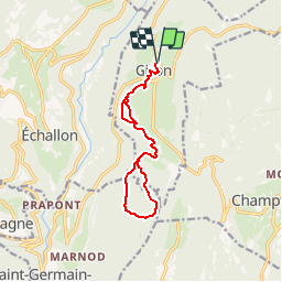
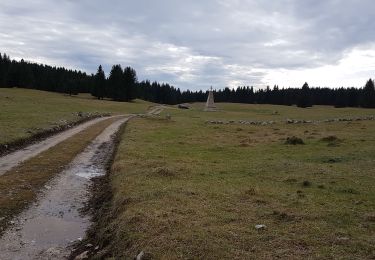
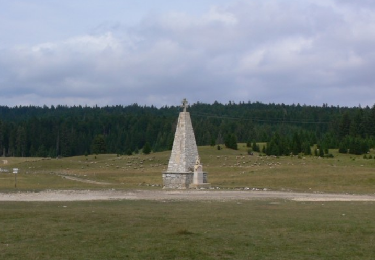
Trail Mountain bike of 12.1 km to be discovered at Auvergne-Rhône-Alpes, Ain, Giron. This trail is proposed by tracegps.

Description

Espace VTT FFC Entre Jura et Léman Circuit officiel labellisé par la Fédération Française de Cyclisme. L'espace VTT FFC Pays de Gex Bellegarde regroupe 13 circuits VTT au départ de 5 sites, répartis sur tout le territoire. Des Monts Jura au plateau de Retord, de la vallée de la Valserine à la plaine du Pays de Gex, le vététiste bucolique ou plus sportif y trouvera un choix d'itinéraires aussi varié que nos paysages. Vous pourrez emprunter les tracés des sentiers de La Grande Traversée du Jura, itinéraire de randonnées de 370 km traversant le Jura du Nord au Sud.Au Col de la Faucille, empruntez des itinéraires spécialement tracés pour découvrir le VTT en famille. Pour tout renseignement sur la pratique du VTT sur le Pays de Gex-Bellegarde, contacter Bruno LADET à bladet chez ccpg point fr

Elevation profile

Positioning

Country:
France
Region :
Auvergne-Rhône-Alpes
Department/Province :
Ain
Municipality :
Giron
Location:
Unknown
Start:(UTM)
713944 ; 5122900 (31T) N.

Comments

Please log in to post a review or rate the element


Trails nearby

Trail Walking Échallon - prairie d'échallon belleydoux la borne aux lion des cernoises - Photo
Walking
loca.yves

Walking

Easy
Échallon, Auvergne-Rhône-Alpes, Ain, France
10.9 km | 14.5 km-effort
3h 2min
Yes
Trail Walking Giron - giron - Photo
Walking
colomb24

Walking

Easy
Giron, Auvergne-Rhône-Alpes, Ain, France
18 km | 25 km-effort
5h 23min
Yes
Trail Walking Échallon - Echallon: moyenne Semine - Photo
Walking
HB01

Walking

Easy
Échallon, Auvergne-Rhône-Alpes, Ain, France
10.5 km | 16.2 km-effort
2h 52min
Yes
Trail Walking Échallon - Forêt d'Echallon, de Belleydoux - Photo
Walking
HB01

Walking

Medium
Échallon, Auvergne-Rhône-Alpes, Ain, France
16.6 km | 24 km-effort
4h 31min
Yes
Trail Walking Champfromier - Champfromier les avalanches  - Photo
Walking
Jackoyo

Walking

Medium
Champfromier, Auvergne-Rhône-Alpes, Ain, France
13.5 km | 22 km-effort
3h 26min
Yes
Trail Horseback riding Giron - 202205 rallye Ain J2 Giron-Lelex - Photo
Horseback riding
xhakon

Horseback riding

Medium
Giron, Auvergne-Rhône-Alpes, Ain, France
21 km | 29 km-effort
4h 0min
No
Trail Walking Giron - Giron - Photo
Walking
Jackoyo

Walking

Easy
Giron, Auvergne-Rhône-Alpes, Ain, France
11.2 km | 15.3 km-effort
2h 41min
Yes
Trail Walking Belleydoux - Prairie d’echallon - Photo
Walking
Jacques01100

Walking

Belleydoux, Auvergne-Rhône-Alpes, Ain, France
5.5 km | 7.3 km-effort
Unknown
Yes
Trail Walking La Pesse - forêt de Chapuzieux - Photo
Walking
Jackoyo

Walking

Easy
La Pesse, Bourgogne-Franche-Comté, Jura, France
12.5 km | 18.3 km-effort
2h 51min
Yes


Close
My subscriptions