Trail Mountain bike Lamoura - Randonnée VTT - Le Jura de Haut en Bas édition 2009 - Photo

Randonnée VTT - Le Jura de Haut en Bas édition 2009

 tracegps
tracegps

User

© OpenStreetMap contributors
Length
Length
99 km
Max alt
Max alt
1248 m
Uphill gradient
Uphill gradient
2103 m
Km-Effort
Km-Effort  
130 km
Min alt
Min alt
256 m
Downhill gradient
Downhill gradient
3028 m
Boucle
Boucle
No
Creation date :
2014-12-10 00:00:00.0
Updated on :
2014-12-10 00:00:00.0

(0 Reviews)

Mountain bike
Mountain bike
7h00
Difficulty : Very difficult

Scan this QR Code to open this trail in the SityTrail application

FREE GPS app for hiking

Logo SityTrail SityTrail

IGN / Geographical institutes

Download SityTrail from the App Store Download SityTrail from Google Play

Logo SityTrail SityTrail World

The world is yours!

Download SityTrail from the App Store Download SityTrail from Google Play Download SityTrail on Huawei AppGallery

About

Trail Mountain bike of 99 km to be discovered at Bourgogne-Franche-Comté, Jura, Lamoura. This trail is proposed by tracegps.

Description

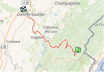
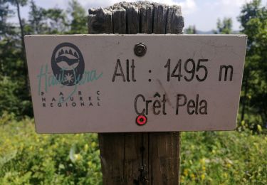
Randonnée VTT - Le Jura de Haut en Bas édition 2009 Cette traditionnelle randonnée sans esprit de compétition et ouverte à tous, dont le succès ne se dément pas après déjà 13éditions, permet de découvrir dans une ambiance chaleureuse et festive les paysages et le patrimoine jurassien entre LAMOURA et LONS LE SAUNIER. Sur cet itinéraire entièrement balisé et fléché d'une centaine de kilomètres, 3 points de départ intermédiaires sont proposés pour permettre à chacun d'adapter son parcours à sa condition physique du moment : Château des Prés (75km), Meussia (50km) et Dompierre sur Mont (25km). Des ravitaillements bien garnis jalonneront le parcours jusqu'à Lons le Saunier, point d'arrivée commun à tous les participants. Toutes les infos sur le site de la Section cyclotourisme de l'Amicale Laïque Lédonienne.

Elevation profile

Photos

Positioning

Country:
France
Region :
Bourgogne-Franche-Comté
Department/Province :
Jura
Municipality :
Lamoura
Location:
Unknown
Start:(UTM)
728214 ; 5142428 (31T) N.

Trails nearby

Trail Walking Septmoncel les Molunes - circuit des chamois Septmoncel  - Photo
Walking
zoe.vienne

Walking

Difficult
(1)
Septmoncel les Molunes, Bourgogne-Franche-Comté, Jura, France
16.3 km | 31 km-effort
5h 51min
Yes
Trail Walking Lamoura - Tresberruy - Lamoura - Photo
Walking
tracegps

Walking

Difficult
(1)
Lamoura, Bourgogne-Franche-Comté, Jura, France
14.5 km | 20 km-effort
4h 0min
Yes
Trail Cycle Lajoux - 2023-08-18_15h23m20_lamoura - Photo
Cycle
daniellebou

Cycle

Very easy
(1)
Lajoux, Bourgogne-Franche-Comté, Jura, France
21 km | 26 km-effort
Unknown
Yes
Trail Running Mijoux - UTTJ 2015-2 - Photo
Running
bourel.jacques

Running

Very difficult
(1)
Mijoux, Auvergne-Rhône-Alpes, Ain, France
57 km | 92 km-effort
18h 13min
No
Trail Walking Gex - Balade à Col de la Faucille, Gex - Photo
Walking
Gaiato

Walking

Very difficult
Gex, Auvergne-Rhône-Alpes, Ain, France
86 km | 135 km-effort
9h 23min
No
Trail Bicycle tourism Mijoux - LES ROUSSES - COL DE LA FAUCILLE  - Photo
Bicycle tourism
jean-marie.parachini

Bicycle tourism

Very difficult
Mijoux, Auvergne-Rhône-Alpes, Ain, France
54 km | 68 km-effort
4h 57min
No
Trail Walking Lamoura - Autour Lamoura - Photo
Walking
swp648

Walking

Medium
Lamoura, Bourgogne-Franche-Comté, Jura, France
17.1 km | 25 km-effort
4h 37min
Yes
Trail Walking Lamoura - Le Crêt Pela - Photo
Walking
Le jurassien

Walking

Medium
Lamoura, Bourgogne-Franche-Comté, Jura, France
21 km | 28 km-effort
5h 37min
Yes
Trail Snowshoes Lamoura - Lamoura 14km D+ 493 20210228 - Photo
Snowshoes
cmike39

Snowshoes

Very easy
Lamoura, Bourgogne-Franche-Comté, Jura, France
14 km | 21 km-effort
3h 36min
Yes


Close
My subscriptions