Trail Mountain bike Pouilley-les-Vignes - Canton d'Audeux - Pouilley les Vignes - Photo

Canton d'Audeux - Pouilley les Vignes

 tracegps
tracegps

User

© OpenStreetMap contributors
Length
Length
18.4 km
Max alt
Max alt
358 m
Uphill gradient
Uphill gradient
400 m
Km-Effort
Km-Effort  
24 km
Min alt
Min alt
217 m
Downhill gradient
Downhill gradient
402 m
Boucle
Boucle
Yes
Creation date :
2014-12-10 00:00:00.0
Updated on :
2014-12-10 00:00:00.0

(0 Reviews)

Mountain bike
Mountain bike
1h45
Difficulty : Medium

Scan this QR Code to open this trail in the SityTrail application

FREE GPS app for hiking

Logo SityTrail SityTrail

IGN / Geographical institutes

Download SityTrail from the App Store Download SityTrail from Google Play

Logo SityTrail SityTrail World

The world is yours!

Download SityTrail from the App Store Download SityTrail from Google Play Download SityTrail on Huawei AppGallery

About

Trail Mountain bike of 18.4 km to be discovered at Bourgogne-Franche-Comté, Doubs, Pouilley-les-Vignes. This trail is proposed by tracegps.

Description

Ce parcours est classé de niveau bleu. Il est assez facile, les montées sont progressives, il n'y a pas d'un coup de forte pente. Il débute par un sentier au bord de l'autoroute avant d'entrer dans le bois. On alterne ensuite entre chemins goudronnés dans les villages et chemins en petits cailloux bien agréables. En arrivant à l'ancienne voie ferrée, attention de ne pas manquer l'entrée, il faut traverser le champ à droite avant le petit pont. Ce passage de voie ferrée entre 2 falaises est très rigolo. Attention tout de même, ce sont de gros cailloux au sol, qui ont d'ailleurs été recouverts par plein de ronces. Ce parcours très varié (routes goudronnées, chemins, sentiers dans les bois, cailloux) est à faire en début de saison pour la reprise.

Elevation profile

Photos

Positioning

Country:
France
Region :
Bourgogne-Franche-Comté
Department/Province :
Doubs
Municipality :
Pouilley-les-Vignes
Location:
Unknown
Start:(UTM)
721452 ; 5238359 (31T) N.

Trails nearby

Trail Walking Serre-les-Sapins - serre les sapins la ménère - Photo
Walking
eltonnermou

Walking

Very easy
(1)
Serre-les-Sapins, Bourgogne-Franche-Comté, Doubs, France
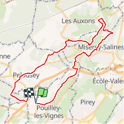
10.4 km | 12.6 km-effort
1h 48min
Yes
Trail On foot Besançon - Circuit de Planoise - Photo
On foot
PRO

On foot

Easy
Besançon, Bourgogne-Franche-Comté, Doubs, France
4.6 km | 7.6 km-effort
1h 43min
Yes
Trail Mountain bike Audeux - audeux classik 30 - Photo
Mountain bike
nono25170

Mountain bike

Very easy
(2)
Audeux, Bourgogne-Franche-Comté, Doubs, France
29 km | 36 km-effort
1h 15min
Yes
Trail Other activity Besançon - centre ville  - Photo
Other activity
fcochard

Other activity

Very easy
(1)
Besançon, Bourgogne-Franche-Comté, Doubs, France
4.2 km | 4.9 km-effort
13min
No
Trail Mountain bike École-Valentin - marchaux dame blanche chatillon - Photo
Mountain bike
zack25

Mountain bike

Very easy
(2)
École-Valentin, Bourgogne-Franche-Comté, Doubs, France
35 km | 44 km-effort
Unknown
Yes
Trail Walking Serre-les-Sapins - serre les sapins via pirey - Photo
Walking
eltonnermou

Walking

Easy
(1)
Serre-les-Sapins, Bourgogne-Franche-Comté, Doubs, France
14 km | 17.7 km-effort
2h 26min
Yes
Trail Walking Chaucenne - chaucenne long - Photo
Walking
eltonnermou

Walking

Medium
Chaucenne, Bourgogne-Franche-Comté, Doubs, France
22 km | 25 km-effort
3h 44min
Yes
Trail Walking Chaucenne - chaucen..ne perd rien - Photo
Walking
eltonnermou

Walking

Easy
(1)
Chaucenne, Bourgogne-Franche-Comté, Doubs, France
13.9 km | 16.8 km-effort
3h 49min
Yes
Trail Walking Serre-les-Sapins - rando serre pirey  - Photo
Walking
mig26

Walking

Easy
(1)
Serre-les-Sapins, Bourgogne-Franche-Comté, Doubs, France
12.2 km | 15.6 km-effort
3h 14min
Yes


Close
My subscriptions