Trail Walking Chaucenne - chaucenne long - Photo
© OpenStreetMap contributors
Length
Length
22 km
Max alt
Max alt
265 m
Uphill gradient
Uphill gradient
273 m
Km-Effort
Km-Effort  
25 km
Min alt
Min alt
199 m
Downhill gradient
Downhill gradient
273 m
Boucle
Boucle
Yes
Creation date :
2023-12-10 08:33:20.284
Updated on :
2023-12-16 18:19:26.65

(0 Reviews)

Walking
Walking
3h44
Difficulty : Medium

Scan this QR Code to open this trail in the SityTrail application

FREE GPS app for hiking

Logo SityTrail SityTrail

IGN / Geographical institutes

Download SityTrail from the App Store Download SityTrail from Google Play

Logo SityTrail SityTrail World

The world is yours!

Download SityTrail from the App Store Download SityTrail from Google Play Download SityTrail on Huawei AppGallery

About

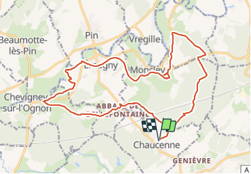
Trail Walking of 22 km to be discovered at Bourgogne-Franche-Comté, Doubs, Chaucenne. This trail is proposed by eltonnermou.

Description

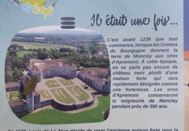
Randonnée très agréable, de très belles bâtisses et château (Moncley) abbaye de bellefontaine .... à travers le paysage vallonné de notre région, avec de longues parties boisées.
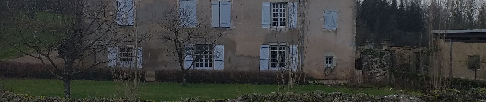
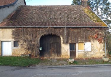
Profitez de la traversée des villages pour admirez les belles bâtisses.
Le cheminement le long de l'Ognon après Emagny est désagréable, le sentier n'est pas entretenu.  

Elevation profile

Photos

Positioning

Country:
France
Region :
Bourgogne-Franche-Comté
Department/Province :
Doubs
Municipality :
Chaucenne
Location:
Unknown
Start:(UTM)
719162 ; 5240983 (31T) N.

Trails nearby

Trail Mountain bike Audeux - audeux classik 30 - Photo
Mountain bike
nono25170

Mountain bike

Very easy
(2)
Audeux, Bourgogne-Franche-Comté, Doubs, France
29 km | 36 km-effort
1h 15min
Yes
Trail Walking Chaucenne - chaucen..ne perd rien - Photo
Walking
eltonnermou

Walking

Easy
(1)
Chaucenne, Bourgogne-Franche-Comté, Doubs, France
13.9 km | 16.8 km-effort
3h 49min
Yes
Trail Walking Placey - Placeý - Photo
Walking
eltonnermou

Walking

Easy
Placey, Bourgogne-Franche-Comté, Doubs, France
13.5 km | 17.4 km-effort
3h 57min
Yes
Trail Walking Serre-les-Sapins - rando serre pirey  - Photo
Walking
mig26

Walking

Easy
(1)
Serre-les-Sapins, Bourgogne-Franche-Comté, Doubs, France
12.2 km | 15.6 km-effort
3h 14min
Yes
Trail Walking Chevigney-sur-l'Ognon - CHEVIGNEY SUR L'OGNON - Photo
Walking
legios84

Walking

Easy
Chevigney-sur-l'Ognon, Bourgogne-Franche-Comté, Doubs, France
8.9 km | 10.1 km-effort
1h 55min
No
Trail Walking Moncley - Moncley  - Photo
Walking
legios84

Walking

Medium
Moncley, Bourgogne-Franche-Comté, Doubs, France
13.2 km | 15.7 km-effort
2h 43min
Yes
Trail Mountain bike Pouilley-les-Vignes - Canton d'Audeux - Pouilley les Vignes - Photo
Mountain bike
tracegps

Mountain bike

Medium
Pouilley-les-Vignes, Bourgogne-Franche-Comté, Doubs, France
18.4 km | 24 km-effort
1h 45min
Yes
Trail Mountain bike Pouilley-les-Vignes - La Fontaine de la Roche - Pouilley les Vignes - Photo
Mountain bike
tracegps

Mountain bike

Medium
Pouilley-les-Vignes, Bourgogne-Franche-Comté, Doubs, France
28 km | 35 km-effort
2h 15min
Yes
Trail Walking Pirey - randonnée pireu - Photo
Walking
Claude THOREL

Walking

Medium
Pirey, Bourgogne-Franche-Comté, Doubs, France
8.9 km | 11.7 km-effort
2h 39min
Yes


Close
My subscriptions