Trail Walking Xonrupt-Longemer - La roche du diable - Etang de Retournemer - Photo

La roche du diable - Etang de Retournemer

 tracegps
tracegps

User

© OpenStreetMap contributors
Length
Length
4.8 km
Max alt
Max alt
1010 m
Uphill gradient
Uphill gradient
294 m
Km-Effort
Km-Effort  
8.7 km
Min alt
Min alt
781 m
Downhill gradient
Downhill gradient
305 m
Boucle
Boucle
Yes
Creation date :
2014-12-10 00:00:00.0
Updated on :
2014-12-10 00:00:00.0

(0 Reviews)

Walking
Walking
4h00
Difficulty : Difficult

Scan this QR Code to open this trail in the SityTrail application

FREE GPS app for hiking

Logo SityTrail SityTrail

IGN / Geographical institutes

Download SityTrail from the App Store Download SityTrail from Google Play

Logo SityTrail SityTrail World

The world is yours!

Download SityTrail from the App Store Download SityTrail from Google Play Download SityTrail on Huawei AppGallery

About

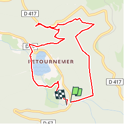
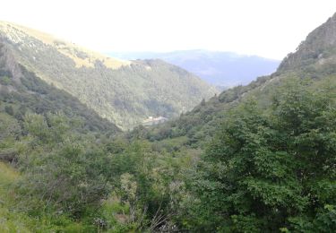
Trail Walking of 4.8 km to be discovered at Grand Est, Vosges, Xonrupt-Longemer. This trail is proposed by tracegps.

Description

Circuit passant par 2 cascades et un point de vue à 1000m d'altitude sur le lac de Retournemer et en partie sur celui de Longemer. Promenade familiale fortement déconseillée car certains passage sont abruptes et risqués pour des enfants. Pas besoin d'être expérimenté, quelqu'un de constitution normale ou même non sportif ne sera pas en difficulté. Tout de même le GPS (avec carte papier) sera une aide car certaines petites parties répertoriées sur la carte ne le sont plus sur le terrain et vice versa. Deux points particuliers: Au pt 11 du tracé, le chemin en pointillé est difficile à trouver car caché par la végétation, dans tous les cas, il faut récupérer le chemin longeant le cours d'eau en contrebas. Dans les alentours du pt 54 (retour du belvédère vers l'étang) vous arriverez à un croisement qui semblera correspondre au croisement du pt 64; il faudra emprunter le chemin de gauche. Pour les amateurs de champignons, à partir du chemin des dames vous pourrez trouver des girolles.

Elevation profile

Photos

Positioning

Country:
France
Region :
Grand Est
Department/Province :
Vosges
Municipality :
Xonrupt-Longemer
Location:
Unknown
Start:(Dec)
Start:(UTM)
350140 ; 5324136 (32U) N.

Trails nearby

Trail Walking La Bresse - 2023-04-16 Marche Abri Lac de Blanchemer vers Lac de Lispach - Photo
Walking
GUIDE
holtzv

Walking

Very difficult
(1)
La Bresse, Grand Est, Vosges, France
23 km | 36 km-effort
8h 4min
No
Trail Walking La Bresse - 2023-04-15 Marche Abri Collet de Etang vers Abri Lac de Blanchemer - Photo
Walking
GUIDE
holtzv

Walking

Medium
(1)
La Bresse, Grand Est, Vosges, France
22 km | 35 km-effort
7h 51min
No
Trail Walking La Bresse - Lac de Lispach et sentier Dielaine  - Photo
Walking
zazie

Walking

Medium
(1)
La Bresse, Grand Est, Vosges, France
9.7 km | 14.9 km-effort
2h 30min
Yes
Trail Walking Stosswihr - Tour du belvedere avec le passage sur les crêtes  - Photo
Walking
ocepee

Walking

Very easy
(2)
Stosswihr, Grand Est, Haut-Rhin, France
8.5 km | 0 m-effort
2h 28min
Yes
Trail Walking La Bresse - Kastelberg des pierres, des lacs, des panoramas magnifiques  - Photo
Walking
Alfredy

Walking

Difficult
(1)
La Bresse, Grand Est, Vosges, France
15.1 km | 26 km-effort
6h 11min
Yes
Trail Walking La Bresse - Les 5 lacs autour du Hohneck - Photo
Walking
tiene

Walking

Very difficult
(1)
La Bresse, Grand Est, Vosges, France
21 km | 36 km-effort
7h 21min
Yes
Trail Walking La Bresse - lac de Lispach - Photo
Walking
fedinois1

Walking

Easy
(1)
La Bresse, Grand Est, Vosges, France
10.4 km | 14.1 km-effort
4h 6min
Yes
Trail Walking La Bresse - lac de Lispach - Photo
Walking
fedinois1

Walking

Easy
(3)
La Bresse, Grand Est, Vosges, France
10.4 km | 14.1 km-effort
4h 6min
Yes
Trail Walking Le Valtin - Les Hirschsteine - Photo
Walking
VacheKiri67

Walking

Difficult
(1)
Le Valtin, Grand Est, Vosges, France
16.1 km | 25 km-effort
6h 28min
Yes


Close
My subscriptions