Trail Walking Saint-Nicolas-la-Chapelle - tour par croix cartier depuis Nanchard - Photo

tour par croix cartier depuis Nanchard

 biollay
biollay

User

© OpenStreetMap contributors
Length
Length
8.9 km
Max alt
Max alt
1830 m
Uphill gradient
Uphill gradient
584 m
Km-Effort
Km-Effort  
16.8 km
Min alt
Min alt
1263 m
Downhill gradient
Downhill gradient
598 m
Boucle
Boucle
Yes
Creation date :
2019-06-29 13:07:17.271
Updated on :
2019-06-29 13:07:17.57

(0 Reviews)

Walking
Walking
3h32
Difficulty : Medium

Scan this QR Code to open this trail in the SityTrail application

FREE GPS app for hiking

Logo SityTrail SityTrail

IGN / Geographical institutes

Download SityTrail from the App Store Download SityTrail from Google Play

Logo SityTrail SityTrail World

The world is yours!

Download SityTrail from the App Store Download SityTrail from Google Play Download SityTrail on Huawei AppGallery

About

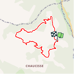
Trail Walking of 8.9 km to be discovered at Auvergne-Rhône-Alpes, Savoy, Saint-Nicolas-la-Chapelle. This trail is proposed by biollay.

Description

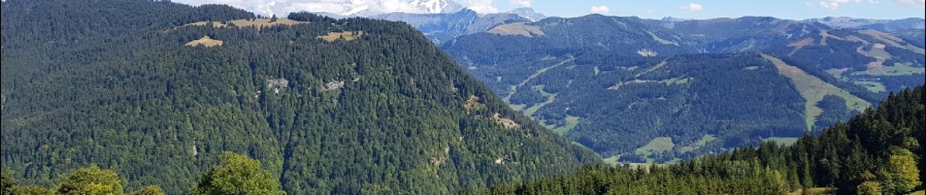
balade en forêt et belles fenêtres paysagères

Elevation profile

Photos

Positioning

Country:
France
Region :
Auvergne-Rhône-Alpes
Department/Province :
Savoy
Municipality :
Saint-Nicolas-la-Chapelle
Location:
Unknown
Start:(UTM)
305609 ; 5079064 (32T) N.

Trails nearby

Trail Walking La Giettaz - Le Plan - col de Jaillet - Photo
Walking
wbarge

Walking

Medium
(2)
La Giettaz, Auvergne-Rhône-Alpes, Savoy, France
11.9 km | 19.7 km-effort
4h 18min
Yes
Trail Walking La Giettaz - Boucle de Croisse Baulet - Photo
Walking
olivecoco

Walking

Medium
(1)
La Giettaz, Auvergne-Rhône-Alpes, Savoy, France
9.4 km | 23 km-effort
4h 2min
Yes
Trail Snowshoes La Clusaz - col aravis - Photo
Snowshoes
myjackotte

Snowshoes

Easy
(2)
La Clusaz, Auvergne-Rhône-Alpes, Upper Savoy, France
5.7 km | 8.2 km-effort
2h 16min
Yes
Trail Other activity La Giettaz - croise baulet - Photo
Other activity
twistss

Other activity

Very easy
(3)
La Giettaz, Auvergne-Rhône-Alpes, Savoy, France
12.1 km | 27 km-effort
3h 30min
Yes
Trail Walking Notre-Dame-de-Bellecombe - NOTRE DAME DE BELLECOMBE - Photo
Walking
albertville

Walking

Very easy
(3)
Notre-Dame-de-Bellecombe, Auvergne-Rhône-Alpes, Savoy, France
13.3 km | 23 km-effort
5h 15min
Yes
Trail Walking Saint-Nicolas-la-Chapelle - Saint Nicolas la Chapelle - Photo
Walking
albertville

Walking

Very easy
(1)
Saint-Nicolas-la-Chapelle, Auvergne-Rhône-Alpes, Savoy, France
9.3 km | 18.2 km-effort
4h 3min
Yes
Trail Walking Saint-Nicolas-la-Chapelle - SAINT NICOLAS LA CHAPELLE - Photo
Walking
albertville

Walking

Very easy
(1)
Saint-Nicolas-la-Chapelle, Auvergne-Rhône-Alpes, Savoy, France
9.5 km | 16.8 km-effort
3h 41min
No
Trail Motor La Giettaz - La Giettaz - Col des Aravis - Photo
Motor
albertville

Motor

Very easy
(1)
La Giettaz, Auvergne-Rhône-Alpes, Savoy, France
15.8 km | 23 km-effort
58min
No
Trail Walking La Clusaz - Col des ARAVIS ... la Croix des Frêtes. - Photo
Walking
GerardBouche

Walking

Difficult
La Clusaz, Auvergne-Rhône-Alpes, Upper Savoy, France
7.4 km | 12.1 km-effort
2h 14min
Yes


Close
My subscriptions