Trail Walking Pelves - Pelves - Monchy le Preux - Boiry Notre Dame - Photo

Pelves - Monchy le Preux - Boiry Notre Dame

 tracegps
tracegps

User

© OpenStreetMap contributors
Length
Length
9.9 km
Max alt
Max alt
109 m
Uphill gradient
Uphill gradient
92 m
Km-Effort
Km-Effort  
11.2 km
Min alt
Min alt
45 m
Downhill gradient
Downhill gradient
93 m
Boucle
Boucle
Yes
Creation date :
2014-12-10 00:00:00.0
Updated on :
2014-12-10 00:00:00.0

(0 Reviews)

Walking
Walking
2h00
Difficulty : Medium

Scan this QR Code to open this trail in the SityTrail application

FREE GPS app for hiking

Logo SityTrail SityTrail

IGN / Geographical institutes

Download SityTrail from the App Store Download SityTrail from Google Play

Logo SityTrail SityTrail World

The world is yours!

Download SityTrail from the App Store Download SityTrail from Google Play Download SityTrail on Huawei AppGallery

About

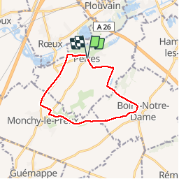
Trail Walking of 9.9 km to be discovered at Hauts-de-France, Pas-de-Calais, Pelves. This trail is proposed by tracegps.

Description

Randonnée au départ de Pelves qui fait le tour par Monchy le Preux et Boiry Notre Dame par les chemins à travers champs.

Elevation profile

Photos

Positioning

Country:
France
Region :
Hauts-de-France
Department/Province :
Pas-de-Calais
Municipality :
Pelves
Location:
Unknown
Start:(UTM)
494029 ; 5570911 (31U) N.

Trails nearby

Trail Walking Monchy-le-Preux - Le chemin du Caribou - Monchy le Preux - Photo
Walking
tracegps

Walking

Medium
(1)
Monchy-le-Preux, Hauts-de-France, Pas-de-Calais, France
9.2 km | 10.1 km-effort
2h 19min
Yes
Trail Walking Rœux - De Roeux à Pelves via Monchy-le-Preux - Photo
Walking
tracegps

Walking

Medium
Rœux, Hauts-de-France, Pas-de-Calais, France
9.5 km | 10.6 km-effort
2h 30min
Yes
Trail Walking Rœux - De Roeux à Plouvain - Photo
Walking
tracegps

Walking

Easy
Rœux, Hauts-de-France, Pas-de-Calais, France
6.3 km | 6.6 km-effort
1h 34min
Yes
Trail Walking Rœux - Lacs et marais - Roeux - Photo
Walking
tracegps

Walking

Very difficult
Rœux, Hauts-de-France, Pas-de-Calais, France
18.3 km | 19.6 km-effort
4h 30min
Yes
Trail Walking Fampoux - Des bords de la Scarpe - Fampoux - Photo
Walking
tracegps

Walking

Medium
Fampoux, Hauts-de-France, Pas-de-Calais, France
9.6 km | 10.5 km-effort
2h 25min
Yes
Trail Walking Plouvain - Plouvain le Lac Bleu le marais de Biache Saint Waast - Photo
Walking
roclem421

Walking

Medium
Plouvain, Hauts-de-France, Pas-de-Calais, France
10.3 km | 11.1 km-effort
2h 19min
Yes
Trail Walking Wancourt - Wancourt - Héninel - Guémappe - Photo
Walking
tracegps

Walking

Medium
Wancourt, Hauts-de-France, Pas-de-Calais, France
10.4 km | 11.3 km-effort
2h 0min
Yes
Trail Walking Vitry-en-Artois - Vitry en Artois - Brebières - Photo
Walking
tracegps

Walking

Medium
Vitry-en-Artois, Hauts-de-France, Pas-de-Calais, France
11.1 km | 12 km-effort
2h 0min
Yes
Trail Walking Wancourt - Le chemin de la petite Sensée - Wancourt - Photo
Walking
tracegps

Walking

Medium
Wancourt, Hauts-de-France, Pas-de-Calais, France
10.9 km | 12.2 km-effort
2h 45min
Yes


Close
My subscriptions