Trail Mountain bike Val d'Arry - Le Locheur 2009 50Klm - Photo

Le Locheur 2009 50Klm

 tracegps
tracegps

User

© OpenStreetMap contributors
Length
Length
50 km
Max alt
Max alt
187 m
Uphill gradient
Uphill gradient
763 m
Km-Effort
Km-Effort  
60 km
Min alt
Min alt
50 m
Downhill gradient
Downhill gradient
766 m
Boucle
Boucle
Yes
Creation date :
2014-12-10 00:00:00.0
Updated on :
2014-12-10 00:00:00.0

(0 Reviews)

Mountain bike
Mountain bike
3h30
Difficulty : Medium

Scan this QR Code to open this trail in the SityTrail application

FREE GPS app for hiking

Logo SityTrail SityTrail

IGN / Geographical institutes

Download SityTrail from the App Store Download SityTrail from Google Play

Logo SityTrail SityTrail World

The world is yours!

Download SityTrail from the App Store Download SityTrail from Google Play Download SityTrail on Huawei AppGallery

About

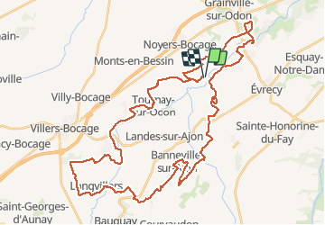
Trail Mountain bike of 50 km to be discovered at Normandy, Calvados, Val d'Arry. This trail is proposed by tracegps.

Description

Peu de grosses difficultés pour ce parcours mais des sentiers sympathiques, de jolis paysages et une intensité constante. L'automne permet de transformer tout VTTiste en Hippopotame soucieux de sa peau.

Elevation profile

Points of interest

Point of interest Val d'Arry - la locheur 2009 49.846 km - Photo
tracegps

Positioning

Country:
France
Region :
Normandy
Department/Province :
Calvados
Municipality :
Val d'Arry
Location:
Le Locheur
Start:(UTM)
678930 ; 5442118 (30U) N.

Trails nearby

Trail Walking Val d'Arry - le locheur-01 - Photo
Walking
gr1346

Walking

Medium
(1)
Val d'Arry, Normandy, Calvados, France
8.4 km | 10.1 km-effort
2h 17min
Yes
Trail Walking Gavrus - gavrus08 - Photo
Walking
gr1346

Walking

Medium
Gavrus, Normandy, Calvados, France
8.5 km | 9.7 km-effort
2h 6min
Yes
Trail Walking Parfouru-sur-Odon - Parfouru - Photo
Walking
gr1346

Walking

Medium
(1)
Parfouru-sur-Odon, Normandy, Calvados, France
9.8 km | 12.1 km-effort
2h 36min
Yes
Trail On foot Val d'Arry - Autour de Le Locheur - Photo
On foot
GUIDE+

On foot

Easy
Val d'Arry, Normandy, Calvados, France
7.9 km | 9.6 km-effort
2h 10min
Yes
Trail On foot Landes-sur-Ajon - De l'Ajon à l'Odon - Photo
On foot
GUIDE+

On foot

Easy
Landes-sur-Ajon, Normandy, Calvados, France
13.2 km | 16.7 km-effort
3h 47min
No
Trail Walking Sainte-Honorine-du-Fay - st honorine du fay - Photo
Walking
yannick14

Walking

Difficult
Sainte-Honorine-du-Fay, Normandy, Calvados, France
12.6 km | 15.8 km-effort
2h 56min
Yes
Trail Walking Sainte-Honorine-du-Fay - st hono dufay  - Photo
Walking
yannick14

Walking

Difficult
(1)
Sainte-Honorine-du-Fay, Normandy, Calvados, France
10.6 km | 13.5 km-effort
3h 4min
Yes
Trail Mountain bike Évrecy - 1er vttae 14062023 - Photo
Mountain bike
cedric14

Mountain bike

Medium
Évrecy, Normandy, Calvados, France
24 km | 28 km-effort
1h 38min
Yes
Trail Hybrid bike Bougy - VELO CAEN 2 - Photo
Hybrid bike
UDGI54

Hybrid bike

Very difficult
Bougy, Normandy, Calvados, France
40 km | 45 km-effort
3h 7min
Yes


Close
My subscriptions