![](/images/other/stat-length.png)
![Trail Mountain bike La Neuveville-devant-Lépanges - Espace VTT FFC Chemins du Coeur des Vosges - circuit n°45 - La breuchotte - Photo](https://media.geolcdn.com/t/1900/400/ext.pjpeg?maxdim=2&url=https%3A%2F%2Fservices.sitytrail.com%2FGeolivesWS%2FDownloadMedia.ashx%3FTrailID%3D104225%26Media%3D7392_1.jpg)
Espace VTT FFC Chemins du Coeur des Vosges - circuit n°45 - La breuchotte
tracegps
User
![Length](/images/other/stat-length.png)
Length
8.3 km
![Max alt](https://static1.geolcdn.com/siteimages/upload/files/1508320355ic_sort_altitude_max_24dp.png)
Max alt
631 m
![Uphill gradient](https://static1.geolcdn.com/siteimages/upload/files/1508320355ic_sort_den_pos_24dp.png)
Uphill gradient
254 m
![Km-Effort](/images/other/stat-length.png)
Km-Effort
11.7 km
![Min alt](https://static1.geolcdn.com/siteimages/upload/files/1508320355ic_sort_altitude_min_24dp.png)
Min alt
467 m
![Downhill gradient](https://static1.geolcdn.com/siteimages/upload/files/1508320355ic_sort_den_neg_24dp.png)
Downhill gradient
254 m
![Boucle](https://static1.geolcdn.com/siteimages/upload/files/16400158638029165_repeat_loop_refresh_sync_direction_icon.png)
Boucle
Yes
Creation date :
2014-12-10 00:00:00.0
Updated on :
2014-12-10 00:00:00.0
![Mountain bike](https://static1.geolcdn.com/sitytour/trail-icons/202.png)
30m
Difficulty : Medium
![Scan this QR Code to open this trail in the SityTrail application](https://capi.geolives.com/qq0zvz2zws4bq2lad0pu/sitytour/trails/104225/qr.png?size=200)
FREE GPS app for hiking
About
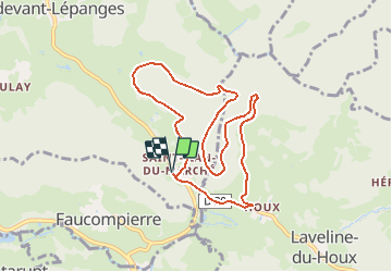
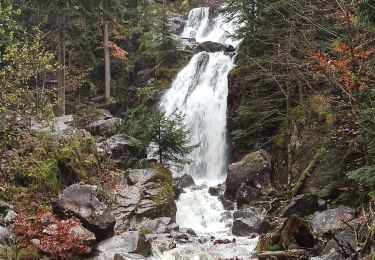
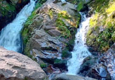
Trail Mountain bike of 8.3 km to be discovered at Grand Est, Vosges, La Neuveville-devant-Lépanges. This trail is proposed by tracegps.
Description
Espace VTT FFC Chemins du Cœur des Vosges - circuit n°45 - La Breuchotte Circuit officiel labellisé par la Fédération Française de Cyclisme. Circuit sans difficultés dans les bois de la Breuchotte et de la Répandise.
Positioning
Country:
France
Region :
Grand Est
Department/Province :
Vosges
Municipality :
La Neuveville-devant-Lépanges
Location:
Unknown
Start:(Dec)
Start:(UTM)
327535 ; 5334888 (32U) N.
Comments
Trails nearby
![Trail Walking Tendon - Cascades de Tendon - Trou de l'Enfer - Roches de la Moulure - Photo](https://media.geolcdn.com/t/375/260/ext.jpg?maxdim=2&url=https%3A%2F%2Fmedia.geolcdn.com%2Ff%2F6cb30f79-01f0-4a87-b35f-5f5af3475353.jpg)
![Walking Walking](https://static1.geolcdn.com/sitytour/trail-icons/101.png)
Cascades de Tendon - Trou de l'Enfer - Roches de la Moulure
Walking
Medium
(3)
Tendon,
Grand Est,
Vosges,
France
![](/images/other/stat-length.png)
20 km | 28 km-effort
5h 33min
![](https://static1.geolcdn.com/siteimages/upload/files/16400158638029165_repeat_loop_refresh_sync_direction_icon.png)
Yes
![Trail Walking Le Tholy - tendon - Photo](https://media.geolcdn.com/t/375/260/ext.jpg?maxdim=2&url=https%3A%2F%2Fstatic1.geolcdn.com%2Fsiteimages%2Fupload%2Ffiles%2F1553511878bg_sport_marche.png)
![Walking Walking](https://static1.geolcdn.com/sitytour/trail-icons/101.png)
![Trail Walking Tendon - cascade - Photo](https://media.geolcdn.com/t/375/260/ext.jpg?maxdim=2&url=https%3A%2F%2Fmedia.geolcdn.com%2Ff%2Fc47e3039-4c04-4707-bbcf-3632202e43bd.jpg)
![Walking Walking](https://static1.geolcdn.com/sitytour/trail-icons/101.png)
![Trail Walking Tendon - cascade du tendon - Photo](https://media.geolcdn.com/t/375/260/ext.jpg?maxdim=2&url=https%3A%2F%2Fmedia.geolcdn.com%2Ff%2F3d41fa8c-b7ab-41a0-86e6-a2fb8a652539.jpg)
![Walking Walking](https://static1.geolcdn.com/sitytour/trail-icons/101.png)
cascade du tendon
Walking
Difficult
Tendon,
Grand Est,
Vosges,
France
![](/images/other/stat-length.png)
8.6 km | 12.2 km-effort
2h 44min
![](https://static1.geolcdn.com/siteimages/upload/files/16400158638029165_repeat_loop_refresh_sync_direction_icon.png)
Yes
![Trail Walking Rehaupal - Champdray - Photo](https://media.geolcdn.com/t/375/260/ext.jpg?maxdim=2&url=https%3A%2F%2Fservices.sitytrail.com%2FGeolivesWS%2FDownloadMedia.ashx%3FTrailID%3D955415%26Media%3Dfix__20180501125437.jpg)
![Walking Walking](https://static1.geolcdn.com/sitytour/trail-icons/101.png)
![Trail Walking Rehaupal - rehaupal 2 march ettes - Photo](https://media.geolcdn.com/t/375/260/ext.jpg?maxdim=2&url=https%3A%2F%2Fstatic1.geolcdn.com%2Fsiteimages%2Fupload%2Ffiles%2F1553511878bg_sport_marche.png)
![Walking Walking](https://static1.geolcdn.com/sitytour/trail-icons/101.png)
rehaupal 2 march ettes
Walking
Medium
(1)
Rehaupal,
Grand Est,
Vosges,
France
![](/images/other/stat-length.png)
10.9 km | 15.7 km-effort
2h 29min
![](https://static1.geolcdn.com/siteimages/upload/files/16400158638029165_repeat_loop_refresh_sync_direction_icon.png)
Yes
![Trail Walking Le Tholy - Les deux Cascades de Tendon - Photo](https://media.geolcdn.com/t/375/260/ext.jpg?maxdim=2&url=https%3A%2F%2Fservices.sitytrail.com%2FGeolivesWS%2FDownloadMedia.ashx%3FTrailID%3D317561%26Media%3D16819_6.jpg)
![Walking Walking](https://static1.geolcdn.com/sitytour/trail-icons/101.png)
Les deux Cascades de Tendon
Walking
Easy
Le Tholy,
Grand Est,
Vosges,
France
![](/images/other/stat-length.png)
3.9 km | 5 km-effort
1h 0min
![](https://static1.geolcdn.com/siteimages/upload/files/16400158638029165_repeat_loop_refresh_sync_direction_icon.png)
Yes
![Trail Walking Tendon - 18-11-23 cascade de Tendon - Photo](https://media.geolcdn.com/t/375/260/ext.jpg?maxdim=2&url=https%3A%2F%2Fmedia.geolcdn.com%2Ff%2F24a4ca35-9dcb-4f5b-946c-f5302e5bfccd.jpg)
![Walking Walking](https://static1.geolcdn.com/sitytour/trail-icons/101.png)
18-11-23 cascade de Tendon
Walking
Medium
Tendon,
Grand Est,
Vosges,
France
![](/images/other/stat-length.png)
7.3 km | 10.3 km-effort
1h 53min
![](https://static1.geolcdn.com/siteimages/upload/files/16400158638029165_repeat_loop_refresh_sync_direction_icon.png)
Yes
![Trail Walking Le Tholy - cascades et hêtre de la vierge - Photo](https://media.geolcdn.com/t/375/260/ext.jpg?maxdim=2&url=https%3A%2F%2Fmedia.geolcdn.com%2Ff%2Ff1db8158-52cf-4baa-aa87-ffe0be91c2af.jpg)
![Walking Walking](https://static1.geolcdn.com/sitytour/trail-icons/101.png)
cascades et hêtre de la vierge
Walking
Very difficult
Le Tholy,
Grand Est,
Vosges,
France
![](/images/other/stat-length.png)
23 km | 32 km-effort
7h 9min
![](https://static1.geolcdn.com/siteimages/upload/files/16400158638029165_repeat_loop_refresh_sync_direction_icon.png)
Yes