Trail Mountain bike Laveline-du-Houx - Espace VTT FFC Chemins du Coeur des Vosges - circuit n°47 - Le col de Malenrupt  - Photo

Espace VTT FFC Chemins du Coeur des Vosges - circuit n°47 - Le col de Malenrupt 

 tracegps
tracegps

User

© OpenStreetMap contributors
Length
Length
8.5 km
Max alt
Max alt
682 m
Uphill gradient
Uphill gradient
261 m
Km-Effort
Km-Effort  
12 km
Min alt
Min alt
459 m
Downhill gradient
Downhill gradient
261 m
Boucle
Boucle
Yes
Creation date :
2014-12-10 00:00:00.0
Updated on :
2014-12-10 00:00:00.0

(0 Reviews)

Mountain bike
Mountain bike
40m
Difficulty : Difficult

Scan this QR Code to open this trail in the SityTrail application

FREE GPS app for hiking

Logo SityTrail SityTrail

IGN / Geographical institutes

Download SityTrail from the App Store Download SityTrail from Google Play

Logo SityTrail SityTrail World

The world is yours!

Download SityTrail from the App Store Download SityTrail from Google Play Download SityTrail on Huawei AppGallery

About

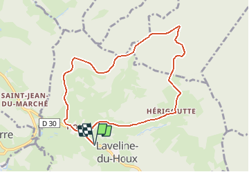
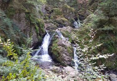
Trail Mountain bike of 8.5 km to be discovered at Grand Est, Vosges, Laveline-du-Houx. This trail is proposed by tracegps.

Description

Espace VTT FFC Chemins du Cœur des Vosges - circuit n°24 - Les Rossieux Circuit officiel labellisé par la Fédération Française de Cyclisme. Au départ du hameau du Houx, vous gravissez l’une des nombreuses collines typiques de cette partie du département. Du col de Malenrupt au hameau de Hérigoutte, la dénivellation réserve ce circuit aux pratiquants réguliers.

Elevation profile

Photos

Positioning

Country:
France
Region :
Grand Est
Department/Province :
Vosges
Municipality :
Laveline-du-Houx
Location:
Unknown
Start:(UTM)
328892 ; 5334093 (32U) N.

Trails nearby

Trail Walking Tendon - Cascades de Tendon - Trou de l'Enfer - Roches de la Moulure - Photo
Walking
Bart2015

Walking

Medium
(3)
Tendon, Grand Est, Vosges, France
20 km | 28 km-effort
5h 33min
Yes
Trail Walking Le Tholy - tendon  - Photo
Walking
michelelfn

Walking

Easy
(4)
Le Tholy, Grand Est, Vosges, France
9.1 km | 12.9 km-effort
3h 1min
Yes
Trail Walking Tendon - cascade  - Photo
Walking
aubr

Walking

Very difficult
Tendon, Grand Est, Vosges, France
20 km | 25 km-effort
1h 51min
No
Trail Walking Tendon - cascade du tendon - Photo
Walking
ghislaine61

Walking

Difficult
Tendon, Grand Est, Vosges, France
8.6 km | 12.2 km-effort
2h 44min
Yes
Trail Walking Le Tholy - les cascades - Photo
Walking
Didier-114

Walking

Very difficult
Le Tholy, Grand Est, Vosges, France
14.3 km | 21 km-effort
5h 52min
Yes
Trail Walking Le Tholy - petit tholy trou de l'enfer  - Photo
Walking
Fred Jspd

Walking

Easy
(1)
Le Tholy, Grand Est, Vosges, France
3.3 km | 5 km-effort
1h 23min
Yes
Trail Walking Rehaupal - Champdray - Photo
Walking
Philou888

Walking

Easy
Rehaupal, Grand Est, Vosges, France
11.3 km | 16.1 km-effort
2h 57min
Yes
Trail Walking Rehaupal - rehaupal 2 march ettes - Photo
Walking
lacote

Walking

Medium
(1)
Rehaupal, Grand Est, Vosges, France
10.9 km | 15.7 km-effort
2h 29min
Yes
Trail Walking Le Tholy - Circuit de la Grande Cascade de Tendon - Photo
Walking
jeanclaude12

Walking

Easy
(1)
Le Tholy, Grand Est, Vosges, France
8.5 km | 11.8 km-effort
3h 27min
Yes


Close
My subscriptions