Trail Cycle Ferrette - La balade des étangs -  Ferrette - Photo

La balade des étangs - Ferrette

 tracegps
tracegps

User

© OpenStreetMap contributors
Length
Length
59 km
Max alt
Max alt
595 m
Uphill gradient
Uphill gradient
718 m
Km-Effort
Km-Effort  
68 km
Min alt
Min alt
292 m
Downhill gradient
Downhill gradient
711 m
Boucle
Boucle
Yes
Creation date :
2014-12-10 00:00:00.0
Updated on :
2014-12-10 00:00:00.0

(0 Reviews)

Cycle
Cycle
3h00
Difficulty : Difficult

Scan this QR Code to open this trail in the SityTrail application

FREE GPS app for hiking

Logo SityTrail SityTrail

IGN / Geographical institutes

Download SityTrail from the App Store Download SityTrail from Google Play

Logo SityTrail SityTrail World

The world is yours!

Download SityTrail from the App Store Download SityTrail from Google Play Download SityTrail on Huawei AppGallery

About

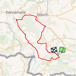
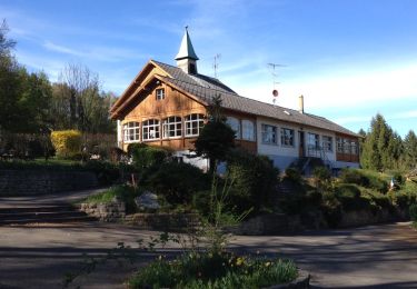
Trail Cycle of 59 km to be discovered at Grand Est, Haut-Rhin, Ferrette. This trail is proposed by tracegps.

Description

Circuit proposé par le Pays de Sundgau et l’Office de Tourisme du Jura Alsacien de Ferrette. Départ du parking de l’Office de Tourisme de Ferrette, 3A rue de Lucelle. Retrouvez le circuit sur le site du Pays de Sundgau . Ce circuit a été numérisé par les randonneurs du CODEPEM. Merci à Jean-Marie.

Elevation profile

Photos

Positioning

Country:
France
Region :
Grand Est
Department/Province :
Haut-Rhin
Municipality :
Ferrette
Location:
Unknown
Start:(UTM)
373011 ; 5261388 (32T) N.

Trails nearby

Trail Walking Ferrette - Ferrette - Grotte des nains - Photo
Walking
regisbodilis

Walking

Easy
(1)
Ferrette, Grand Est, Haut-Rhin, France
13.1 km | 21 km-effort
4h 0min
Yes
Trail Walking Kœstlach - Rando Koestlach...
Walking
boubou68

Walking

Very difficult
Kœstlach, Grand Est, Haut-Rhin, France
22 km | 31 km-effort
6h 43min
Yes
Trail Walking Ferrette - Ferrette ,château, grotte des nains,rossberg - Photo
Walking
jcguew

Walking

Difficult
Ferrette, Grand Est, Haut-Rhin, France
8.6 km | 13.7 km-effort
5h 1min
Yes
Trail Walking Lutter - rdpr 20200929 lutter - Photo
Walking
GUIDE
stempfel52

Walking

Difficult
Lutter, Grand Est, Haut-Rhin, France
15.8 km | 23 km-effort
4h 52min
Yes
Trail Equestrian Bouxwiller - Bouxwiller Doubs Franche Montagne - Photo
Equestrian
meggstone

Equestrian

Difficult
(1)
Bouxwiller, Grand Est, Haut-Rhin, France
104 km | 146 km-effort
18h 22min
No
Trail Walking Ferrette - Ferrette château et grotte des nains - Photo
Walking
juliengsell

Walking

Medium
Ferrette, Grand Est, Haut-Rhin, France
6 km | 9 km-effort
2h 21min
Yes
Trail Road bike Ferrette - Lucelle - Photo
Road bike
PhilippeC54

Road bike

Medium
Ferrette, Grand Est, Haut-Rhin, France
53 km | 66 km-effort
3h 10min
Yes
Trail Walking Ferrette - Ferrette Chalet de Koestlach au Kastelberg - Photo
Walking
domi68440

Walking

Medium
Ferrette, Grand Est, Haut-Rhin, France
14.2 km | 20 km-effort
4h 45min
Yes
Trail Walking Ferrette - Tour du Rossberg - Photo
Walking
dedidi

Walking

Very easy
Ferrette, Grand Est, Haut-Rhin, France
6 km | 8.5 km-effort
1h 55min
Yes


Close
My subscriptions