Trail Walking Casteil - Le Randé Canigou - Photo
 tracegps
tracegps

User

© OpenStreetMap contributors
Length
Length
23 km
Max alt
Max alt
2740 m
Uphill gradient
Uphill gradient
1287 m
Km-Effort
Km-Effort  
40 km
Min alt
Min alt
1517 m
Downhill gradient
Downhill gradient
1304 m
Boucle
Boucle
Yes
Creation date :
2014-12-10 00:00:00.0
Updated on :
2014-12-10 00:00:00.0

(1 Reviews)

Walking
Walking
6h30
Difficulty : Very difficult

Scan this QR Code to open this trail in the SityTrail application

FREE GPS app for hiking

Logo SityTrail SityTrail

IGN / Geographical institutes

Download SityTrail from the App Store Download SityTrail from Google Play

Logo SityTrail SityTrail World

The world is yours!

Download SityTrail from the App Store Download SityTrail from Google Play Download SityTrail on Huawei AppGallery

About

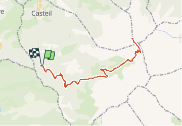
Trail Walking of 23 km to be discovered at Occitania, Pyrénées-Orientales, Casteil. This trail is proposed by tracegps.

Description

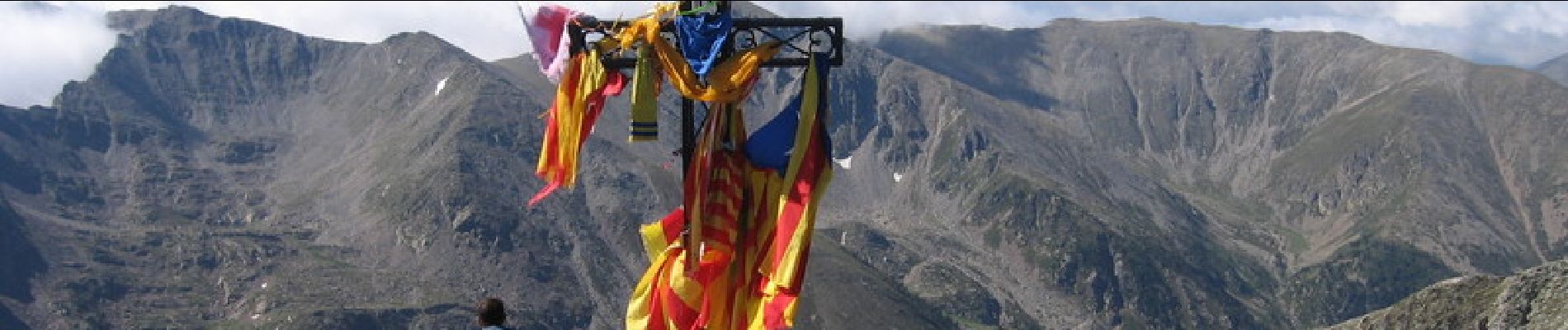
En voiture, de Vernet les Bains, prendre direction Casteil, puis de Casteil direction col de Jou, au col de Jou prendre ( toujours en voiture ) la piste direction le refuge de Mariailles. Cette piste est utilisable par une voiture de tourisme à condition de rouler au pas. À 20 mn à pied avant le refuge se trouve un petit parking, le Randé, c'est là que nous avons laissé la voiture. Ensuite montée classique vers le Canigou, en passant par Mariailles, col Vert, refuge Arago, cheminée, Canigou. Retour par le même chemin Pour ceux qui redoutent la cheminée, pas de difficulté, il faut juste prendre son temps en s'aidant des mains, c'est plus impressionnant que difficile.

Elevation profile

Photos

Points of interest

Point of interest Casteil - 001 - Photo
tracegps
CASTEIL 
Point of interest Vernet-les-Bains - BrècheDurier - Photo
tracegps
VERNET-LES-BAINS 
Point of interest Sahorre - ColdeJou - Photo
tracegps
SAHORRE 
Point of interest Casteil - ColVert - Photo
tracegps
CASTEIL 
Point of interest Casteil - marailles - Photo
tracegps
CASTEIL 
Point of interest Taurinya - PicDuCanigou - Photo
tracegps
TAURINYA 
Point of interest Casteil - RefugeArago - Photo
tracegps
CASTEIL 

Positioning

Country:
France
Region :
Occitania
Department/Province :
Pyrénées-Orientales
Municipality :
Casteil
Location:
Unknown
Start:(UTM)
450327 ; 4706035 (31T) N.

Comments

Please log in to post a review or rate the element


Trails nearby

Trail Walking Casteil - rando casteil du cady - Photo
Walking
attelageplaisir

Walking

Very easy
(1)
Casteil, Occitania, Pyrénées-Orientales, France
5.3 km | 8.7 km-effort
3h 16min
No
Trail Walking Vernet-les-Bains - La tour de Goa - Photo
Walking
tracegps

Walking

Difficult
(2)
Vernet-les-Bains, Occitania, Pyrénées-Orientales, France
15.4 km | 31 km-effort
6h 30min
Yes
Trail Walking Vernet-les-Bains - Cascade des Anglais à Vernet les Bains - Photo
Walking
Pnivarlet

Walking

Difficult
(1)
Vernet-les-Bains, Occitania, Pyrénées-Orientales, France
3.9 km | 6.6 km-effort
1h 34min
Yes
Trail Walking Sahorre - Mattes rouges - Photo
Walking
Machaon6

Walking

Medium
(1)
Sahorre, Occitania, Pyrénées-Orientales, France
11.5 km | 21 km-effort
4h 32min
Yes
Trail Walking Vernet-les-Bains - vernet tours de badabali - Photo
Walking
66Gribouille83

Walking

Difficult
Vernet-les-Bains, Occitania, Pyrénées-Orientales, France
12.5 km | 17.3 km-effort
6h 18min
Yes
Trail Walking Vernet-les-Bains - plc de l'alzina départ chemin de la laiterie Vernet les Bains  - Photo
Walking
Joël.cof

Walking

Medium
Vernet-les-Bains, Occitania, Pyrénées-Orientales, France
7.8 km | 12.4 km-effort
2h 32min
Yes
Trail Walking Vernet-les-Bains - Vernet 2 - Photo
Walking
Christiancordin

Walking

Medium
Vernet-les-Bains, Occitania, Pyrénées-Orientales, France
8.8 km | 14.9 km-effort
2h 27min
No
Trail Walking Casteil - Vernet les Bains - Photo
Walking
Christiancordin

Walking

Medium
Casteil, Occitania, Pyrénées-Orientales, France
7.6 km | 12 km-effort
1h 46min
No
Trail Walking Vernet-les-Bains - 20230611 Vernet-Goa-col deJou-Cadteil - Photo
Walking
ThonyM

Walking

Medium
Vernet-les-Bains, Occitania, Pyrénées-Orientales, France
10.6 km | 19.3 km-effort
3h 2min
Yes


Close
My subscriptions