Trail Mountain bike Verneuil d'Avre et d'Iton - Randonnée des sangliers 2008 43 km - Photo

Randonnée des sangliers 2008 43 km

 tracegps
tracegps

User

© OpenStreetMap contributors
Length
Length
44 km
Max alt
Max alt
199 m
Uphill gradient
Uphill gradient
369 m
Km-Effort
Km-Effort  
49 km
Min alt
Min alt
135 m
Downhill gradient
Downhill gradient
368 m
Boucle
Boucle
Yes
Creation date :
2014-12-10 00:00:00.0
Updated on :
2014-12-10 00:00:00.0

(1 Reviews)

Mountain bike
Mountain bike
2h45
Difficulty : Difficult

Scan this QR Code to open this trail in the SityTrail application

FREE GPS app for hiking

Logo SityTrail SityTrail

IGN / Geographical institutes

Download SityTrail from the App Store Download SityTrail from Google Play

Logo SityTrail SityTrail World

The world is yours!

Download SityTrail from the App Store Download SityTrail from Google Play Download SityTrail on Huawei AppGallery

About

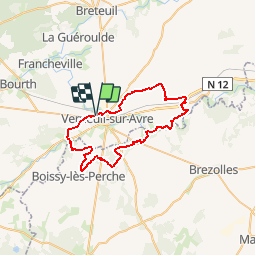
Trail Mountain bike of 44 km to be discovered at Normandy, Eure, Verneuil d'Avre et d'Iton. This trail is proposed by tracegps.

Description

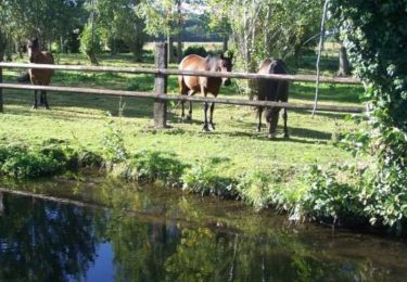
Bonjour Comme pour le 20 km, mais encore plus sympa. sur les berges de l'Avre. Pour ma part, j'ai pris beaucoup de plaisir à faire cette randonnée en 2008, et ceci malgré le vent de face sur toute la fin du parcours. Date à retenir: 07 Novembre 2010: 16ième circuit des sangliers à VERNEUIL (20,40,60,80 km) Bonne randonnée à tous

Elevation profile

Positioning

Country:
France
Region :
Normandy
Department/Province :
Eure
Municipality :
Verneuil d'Avre et d'Iton
Location:
Verneuil-sur-Avre
Start:(UTM)
346629 ; 5400666 (31U) N.

Comments

Please log in to post a review or rate the element


Trails nearby

Trail Walking Verneuil d'Avre et d'Iton - Entre France et Normandie (12 kms) -  Verneuil-sur-Avre - Photo
Walking
tracegps

Walking

Medium
Verneuil d'Avre et d'Iton, Normandy, Eure, France
12 km | 13.3 km-effort
3h 0min
Yes
Trail Walking Verneuil d'Avre et d'Iton - Entre France et Normandie -  Verneuil-sur-Avre - Photo
Walking
tracegps

Walking

Very difficult
(1)
Verneuil d'Avre et d'Iton, Normandy, Eure, France
22 km | 24 km-effort
5h 25min
Yes
Trail Walking Rueil-la-Gadelière - Sur les Pas de Vlaminck -  Rueil-la-Gadelière - Photo
Walking
tracegps

Walking

Medium
Rueil-la-Gadelière, Centre-Loire Valley, Eure-et-Loir, France
8.3 km | 9.2 km-effort
2h 4min
Yes
Trail On foot Verneuil d'Avre et d'Iton - Verneuil sur Avre 20.28 - Photo
On foot
togolo28

On foot

Medium
Verneuil d'Avre et d'Iton, Normandy, Eure, France
20 km | 22 km-effort
Unknown
Yes
Trail Walking Pullay - Pullay Bois Francs 10.1 Km - Photo
Walking
ODDAD78

Walking

Easy
Pullay, Normandy, Eure, France
10.1 km | 11 km-effort
2h 27min
Yes
Trail Walking Verneuil d'Avre et d'Iton - VerneuilsurAvre-Montigny - Photo
Walking
douneto

Walking

Medium
Verneuil d'Avre et d'Iton, Normandy, Eure, France
21 km | 24 km-effort
5h 20min
Yes
Trail Walking Bâlines - Balade Balinoise - Bâlines - Photo
Walking
tracegps

Walking

Easy
Bâlines, Normandy, Eure, France
2.9 km | 3.3 km-effort
45min
Yes
Trail Mountain bike Verneuil d'Avre et d'Iton - Randonnée des sangliers - Photo
Mountain bike
tracegps

Mountain bike

Medium
Verneuil d'Avre et d'Iton, Normandy, Eure, France
57 km | 65 km-effort
3h 0min
Yes
Trail Mountain bike Verneuil d'Avre et d'Iton - Randonnée des sangliers 2008 20 km - Photo
Mountain bike
tracegps

Mountain bike

Medium
Verneuil d'Avre et d'Iton, Normandy, Eure, France
21 km | 23 km-effort
2h 0min
Yes


Close
My subscriptions