Trail Mountain bike Baratier - Espace VTT FFC de l'Embrunais Savinois - Circuit n° 14 - Boucle de la Mûre - Photo

Espace VTT FFC de l'Embrunais Savinois - Circuit n° 14 - Boucle de la Mûre

 tracegps
tracegps

User

© OpenStreetMap contributors
Length
Length
6.6 km
Max alt
Max alt
937 m
Uphill gradient
Uphill gradient
164 m
Km-Effort
Km-Effort  
8.8 km
Min alt
Min alt
786 m
Downhill gradient
Downhill gradient
164 m
Boucle
Boucle
Yes
Creation date :
2014-12-10 00:00:00.0
Updated on :
2014-12-10 00:00:00.0

(0 Reviews)

Mountain bike
Mountain bike
34m
Difficulty : Medium

Scan this QR Code to open this trail in the SityTrail application

FREE GPS app for hiking

Logo SityTrail SityTrail

IGN / Geographical institutes

Download SityTrail from the App Store Download SityTrail from Google Play

Logo SityTrail SityTrail World

The world is yours!

Download SityTrail from the App Store Download SityTrail from Google Play Download SityTrail on Huawei AppGallery

About

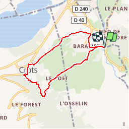
Trail Mountain bike of 6.6 km to be discovered at Provence-Alpes-Côte d'Azur, Hautes-Alpes, Baratier. This trail is proposed by tracegps.

Description

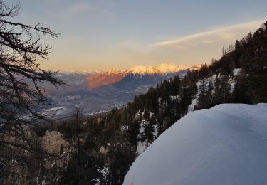
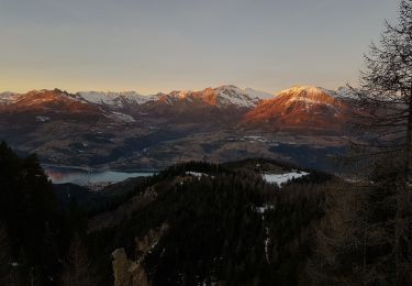
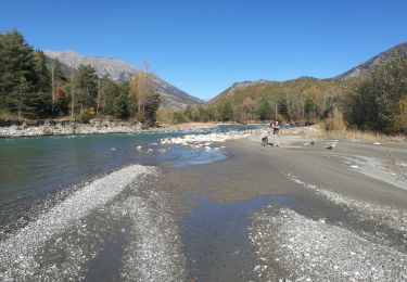
Espace VTT FFC de l'Embrunais Savinois - Circuit n° 14 - Boucle de la Mûre Circuit labellisé par la Fédération Française de Cyclisme. Départ : Baratier, parking avant le pont sur le torrent de Vachère. C’est un circuit facile destiné aux débutants ou aux familles souhaitant s’essayer au VTT. Le circuit passe dans les villages de Crots et de Baratiers, qu’il ne faut pas hésiter à visiter. La montée au-dessus de Baratier offre un joli point de vue sur le lac de Serre-Ponçon. Entre Crots et Baratier, le chemin circule au bord d’un canal, ce qui le rend bien agréable.

Elevation profile

Photos

Positioning

Country:
France
Region :
Provence-Alpes-Côte d'Azur
Department/Province :
Hautes-Alpes
Municipality :
Baratier
Location:
Unknown
Start:(UTM)
301168 ; 4934705 (32T) N.

Trails nearby

Trail Walking Crots - Le Cirque de Morgon - Photo
Walking
tracegps

Walking

Difficult
(5)
Crots, Provence-Alpes-Côte d'Azur, Hautes-Alpes, France
10.6 km | 21 km-effort
5h 30min
Yes
Trail Walking Crots - Morgon par le Grand Clot - Photo
Walking
GUIDE
David25400

Walking

Easy
(1)
Crots, Provence-Alpes-Côte d'Azur, Hautes-Alpes, France
11.8 km | 22 km-effort
5h 49min
Yes
Trail Walking Saint-Sauveur - 2012-08-07 Méale - Photo
Walking
Tchoubi

Walking

Difficult
(1)
Saint-Sauveur, Provence-Alpes-Côte d'Azur, Hautes-Alpes, France
8.3 km | 14.9 km-effort
3h 34min
Yes
Trail Walking Crots - SityTrail - 2251353 - morgon-par-le-grand-clot - Photo
Walking
GUIDE
amiral13

Walking

Medium
Crots, Provence-Alpes-Côte d'Azur, Hautes-Alpes, France
11.8 km | 22 km-effort
5h 30min
Yes
Trail Touring skiing Crots - Pic de Morgon - Photo
Touring skiing
GUIDE
David25400

Touring skiing

Medium
Crots, Provence-Alpes-Côte d'Azur, Hautes-Alpes, France
20 km | 37 km-effort
6h 35min
Yes
Trail Walking Crots - Boscodon 120922 - Photo
Walking
GUIDE
David25400

Walking

Very easy
Crots, Provence-Alpes-Côte d'Azur, Hautes-Alpes, France
7.2 km | 12 km-effort
3h 24min
No
Trail Walking Crots - Grand Morgon - Photo
Walking
Marco05

Walking

Medium
Crots, Provence-Alpes-Côte d'Azur, Hautes-Alpes, France
11.4 km | 22 km-effort
4h 56min
Yes
Trail Snowshoes Crots - Cirque de Morgon, Pic Martin Jean - Photo
Snowshoes
GUIDE
David25400

Snowshoes

Difficult
Crots, Provence-Alpes-Côte d'Azur, Hautes-Alpes, France
18.5 km | 33 km-effort
7h 8min
Yes
Trail Walking Saint-André-d'Embrun - pinée et vietnam 221021 - Photo
Walking
GUIDE
David25400

Walking

Very easy
Saint-André-d'Embrun, Provence-Alpes-Côte d'Azur, Hautes-Alpes, France
39 km | 50 km-effort
4h 23min
No


Close
My subscriptions