Trail Walking Saint-Saud-Lacoussière - Boucle de la Dronne - Saint Saud - Photo

Boucle de la Dronne - Saint Saud

 tracegps
tracegps

User

© OpenStreetMap contributors
Length
Length
13.7 km
Max alt
Max alt
333 m
Uphill gradient
Uphill gradient
265 m
Km-Effort
Km-Effort  
17.2 km
Min alt
Min alt
256 m
Downhill gradient
Downhill gradient
265 m
Boucle
Boucle
Yes
Creation date :
2014-12-10 00:00:00.0
Updated on :
2014-12-10 00:00:00.0

(1 Reviews)

Walking
Walking
2h30
Difficulty : Medium

Scan this QR Code to open this trail in the SityTrail application

FREE GPS app for hiking

Logo SityTrail SityTrail

IGN / Geographical institutes

Download SityTrail from the App Store Download SityTrail from Google Play

Logo SityTrail SityTrail World

The world is yours!

Download SityTrail from the App Store Download SityTrail from Google Play Download SityTrail on Huawei AppGallery

About

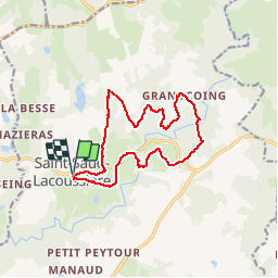
Trail Walking of 13.7 km to be discovered at New Aquitaine, Dordogne, Saint-Saud-Lacoussière. This trail is proposed by tracegps.

Description

Boucle faisant partie des circuits proposés au départ de Saint Saud la Coussière. Possibilité de rejoindre les boucles de Saint Pardoux et Miallet notamment.

Elevation profile

Positioning

Country:
France
Region :
New Aquitaine
Department/Province :
Dordogne
Municipality :
Saint-Saud-Lacoussière
Location:
Unknown
Start:(UTM)
329744 ; 5045577 (31T) N.

Comments

Please log in to post a review or rate the element


merci. ce circuit nous a permis d elaborer nos pistes sans avoir a aller en reconnaissance sur le terrain pour elaborer a partir de l ensemble nos propres tronçons de pistes pour nos entrainements. Merci


Trails nearby

Trail Walking Champs-Romain - Champs-Romain Tacot 12km - Photo
Walking
YV24

Walking

Difficult
Champs-Romain, New Aquitaine, Dordogne, France
11.6 km | 14.3 km-effort
3h 6min
Yes
Trail Walking Champs-Romain - saut du chalard par Larret - Photo
Walking
Zygomat

Walking

Difficult
Champs-Romain, New Aquitaine, Dordogne, France
9.9 km | 13.5 km-effort
2h 56min
Yes
Trail Walking Champs-Romain - Périgord vert saut du chalard - Photo
Walking
attelageplaisir

Walking

Very easy
Champs-Romain, New Aquitaine, Dordogne, France
3.8 km | 5.2 km-effort
1h 39min
Yes
Trail Walking Abjat-sur-Bandiat - GR4-67 - Abjat sur Bandiat -  Le Chambon - Photo
Walking
Tournan

Walking

Very difficult
Abjat-sur-Bandiat, New Aquitaine, Dordogne, France
30 km | 37 km-effort
7h 54min
No
Trail Walking Saint-Saud-Lacoussière - Saint Saud Lacoussiere - Photo
Walking
Zygomat

Walking

Easy
Saint-Saud-Lacoussière, New Aquitaine, Dordogne, France
11.8 km | 15.2 km-effort
3h 16min
Yes
Trail Walking Champs-Romain - Saut du chaland Dordogne - Photo
Walking
jumbo0861

Walking

Easy
Champs-Romain, New Aquitaine, Dordogne, France
2.7 km | 3.9 km-effort
49min
Yes


Close
My subscriptions