Trail Walking Champs-Romain - saut du chalard par Larret - Photo

saut du chalard par Larret

 Zygomat
Zygomat

User

© OpenStreetMap contributors
Length
Length
9.9 km
Max alt
Max alt
308 m
Uphill gradient
Uphill gradient
268 m
Km-Effort
Km-Effort  
13.5 km
Min alt
Min alt
166 m
Downhill gradient
Downhill gradient
266 m
Boucle
Boucle
Yes
Creation date :
2014-12-10 00:00:00.0
Updated on :
2014-12-10 00:00:00.0

(0 Reviews)

Walking
Walking
2h56
Difficulty : Difficult

Scan this QR Code to open this trail in the SityTrail application

FREE GPS app for hiking

Logo SityTrail SityTrail

IGN / Geographical institutes

Download SityTrail from the App Store Download SityTrail from Google Play

Logo SityTrail SityTrail World

The world is yours!

Download SityTrail from the App Store Download SityTrail from Google Play Download SityTrail on Huawei AppGallery

About

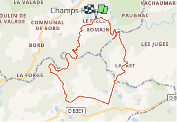
Trail Walking of 9.9 km to be discovered at New Aquitaine, Dordogne, Champs-Romain. This trail is proposed by Zygomat.

Description

Pour voir l'autre face du saut du Chalard. Départ et arrivée du parking du saut du Chalard. !!! Attention !!! La difficulté de cette boucle est la traversée de la rivière : prévoir des chaussures pour la traversée, en été l'eau arrive  sous les genoux, gare au courant et aux rochers glissants.

Elevation profile

Positioning

Country:
France
Region :
New Aquitaine
Department/Province :
Dordogne
Municipality :
Champs-Romain
Location:
Unknown
Start:(UTM)
326829 ; 5044174 (31T) N.

Trails nearby

Trail Walking Saint-Pardoux-la-Rivière - St-Pardoux-la-Rivière Dorie 13km - Photo
Walking
YV24

Walking

Easy
(1)
Saint-Pardoux-la-Rivière, New Aquitaine, Dordogne, France
12.4 km | 15.8 km-effort
3h 26min
Yes
Trail Walking Saint-Saud-Lacoussière - Boucle de la Dronne - Saint Saud - Photo
Walking
tracegps

Walking

Medium
(1)
Saint-Saud-Lacoussière, New Aquitaine, Dordogne, France
13.7 km | 17.2 km-effort
2h 30min
Yes
Trail Walking Champs-Romain - Champs-Romain Tacot 12km - Photo
Walking
YV24

Walking

Difficult
Champs-Romain, New Aquitaine, Dordogne, France
11.6 km | 14.3 km-effort
3h 6min
Yes
Trail Hybrid bike Saint-Pardoux-la-Rivière - Balade à vélo voie verte st pardaux la rivière - Photo
Hybrid bike
jumbo0861

Hybrid bike

Very easy
Saint-Pardoux-la-Rivière, New Aquitaine, Dordogne, France
34 km | 40 km-effort
3h 3min
No
Trail Walking Champs-Romain - Périgord vert saut du chalard - Photo
Walking
attelageplaisir

Walking

Very easy
Champs-Romain, New Aquitaine, Dordogne, France
3.8 km | 5.2 km-effort
1h 39min
Yes
Trail Walking Saint-Pardoux-la-Rivière - Boucle- st  pardoux - Photo
Walking
Melifera

Walking

Very difficult
Saint-Pardoux-la-Rivière, New Aquitaine, Dordogne, France
19.4 km | 25 km-effort
5h 34min
No
Trail sport Saint-Pardoux-la-Rivière - 2021-02-24_01h29m54_Boucle PNR 191 km Variante Avril 2019 - Photo
sport
vimpere

sport

Very easy
Saint-Pardoux-la-Rivière, New Aquitaine, Dordogne, France
195 km | 241 km-effort
Unknown
Yes
Trail Walking Saint-Saud-Lacoussière - Saint Saud Lacoussiere - Photo
Walking
Zygomat

Walking

Easy
Saint-Saud-Lacoussière, New Aquitaine, Dordogne, France
11.8 km | 15.2 km-effort
3h 16min
Yes
Trail Walking Champs-Romain - Saut du chaland Dordogne - Photo
Walking
jumbo0861

Walking

Easy
Champs-Romain, New Aquitaine, Dordogne, France
2.7 km | 3.9 km-effort
49min
Yes


Close
My subscriptions