Trail Mountain bike Sainte-Honorine-du-Fay - Autour de Trois-Monts - Sainte Honorine du Fay - Photo

Autour de Trois-Monts - Sainte Honorine du Fay

 tracegps
tracegps

User

© OpenStreetMap contributors
Length
Length
31 km
Max alt
Max alt
167 m
Uphill gradient
Uphill gradient
574 m
Km-Effort
Km-Effort  
39 km
Min alt
Min alt
13 m
Downhill gradient
Downhill gradient
572 m
Boucle
Boucle
Yes
Creation date :
2014-12-10 00:00:00.0
Updated on :
2014-12-10 00:00:00.0

(0 Reviews)

Mountain bike
Mountain bike
2h10
Difficulty : Difficult

Scan this QR Code to open this trail in the SityTrail application

FREE GPS app for hiking

Logo SityTrail SityTrail

IGN / Geographical institutes

Download SityTrail from the App Store Download SityTrail from Google Play

Logo SityTrail SityTrail World

The world is yours!

Download SityTrail from the App Store Download SityTrail from Google Play Download SityTrail on Huawei AppGallery

About

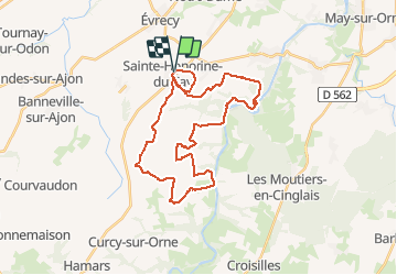
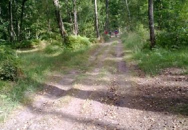
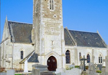
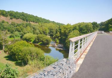
Trail Mountain bike of 31 km to be discovered at Normandy, Calvados, Sainte-Honorine-du-Fay. This trail is proposed by tracegps.

Description

Circuit au départ de Sainte Honorine du Fay pour une balade vtt d'environ 02h10. Le parcours gps compte 02h30, car il faut rajouter une chute et une crevaison (eh oui ça arrive). Un itinéraire qui vous permettra de découvrir les bords de l'Orne, des bois, de rencontrer des chevaux ou des bovins sur les chemins. quelques belles vues sur la suisse normande ainsi que la ville de Caen au kilomètre 21. Attention aux cailloux dans les descentes. Bonne balade !!

Elevation profile

Positioning

Country:
France
Region :
Normandy
Department/Province :
Calvados
Municipality :
Sainte-Honorine-du-Fay
Location:
Unknown
Start:(UTM)
683164 ; 5439161 (30U) N.

Trails nearby

Trail Mountain bike Montillières-sur-Orne - curcy trois monts - Photo
Mountain bike
albers

Mountain bike

Medium
(1)
Montillières-sur-Orne, Normandy, Calvados, France
28 km | 35 km-effort
1h 59min
Yes
Trail Walking Gavrus - gavrus08 - Photo
Walking
gr1346

Walking

Medium
Gavrus, Normandy, Calvados, France
8.5 km | 9.7 km-effort
2h 6min
Yes
Trail Walking Vieux - Vieux-jp - Photo
Walking
gr1346

Walking

Medium
(1)
Vieux, Normandy, Calvados, France
8.9 km | 10.4 km-effort
2h 37min
No
Trail Walking Maizet - COUDRAY 20 KM - Photo
Walking
UDGI54

Walking

Difficult
(2)
Maizet, Normandy, Calvados, France
19.8 km | 25 km-effort
5h 26min
Yes
Trail Mountain bike Amayé-sur-Orne - Xtrem Vtt Normandie 2013 - Amayé Sur Orne - Photo
Mountain bike
tracegps

Mountain bike

Difficult
Amayé-sur-Orne, Normandy, Calvados, France
45 km | 57 km-effort
2h 49min
Yes
Trail Running Mutrécy - reco mouss 27 12 13 - Photo
Running
mouss65

Running

Very easy
(1)
Mutrécy, Normandy, Calvados, France
5.7 km | 7.6 km-effort
1h 59min
No
Trail sport Vieux - Autour de Vieux la Romaine  - Photo
sport
papylou7

sport

Very easy
Vieux, Normandy, Calvados, France
35 km | 40 km-effort
Unknown
No
Trail On foot Val d'Arry - Autour de Le Locheur - Photo
On foot
PRO

On foot

Easy
Val d'Arry, Normandy, Calvados, France
7.9 km | 9.6 km-effort
2h 10min
Yes
Trail On foot Grimbosq - Moulin de Pray et Pont de Brie - Photo
On foot
PRO

On foot

Easy
Grimbosq, Normandy, Calvados, France
4.3 km | 4.9 km-effort
1h 6min
No


Close
My subscriptions