Trail Running Lacapelle-Biron - VTT à Saint Avit - Photo
 tracegps
tracegps

User

© OpenStreetMap contributors
Length
Length
21 km
Max alt
Max alt
219 m
Uphill gradient
Uphill gradient
402 m
Km-Effort
Km-Effort  
26 km
Min alt
Min alt
148 m
Downhill gradient
Downhill gradient
405 m
Boucle
Boucle
Yes
Creation date :
2014-12-10 00:00:00.0
Updated on :
2014-12-10 00:00:00.0

(0 Reviews)

Running
Running
3h00
Difficulty : Medium

Scan this QR Code to open this trail in the SityTrail application

FREE GPS app for hiking

Logo SityTrail SityTrail

IGN / Geographical institutes

Download SityTrail from the App Store Download SityTrail from Google Play

Logo SityTrail SityTrail World

The world is yours!

Download SityTrail from the App Store Download SityTrail from Google Play Download SityTrail on Huawei AppGallery

About

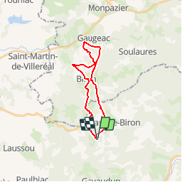
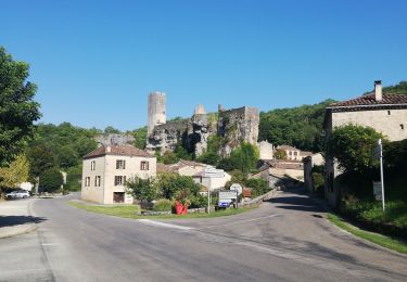
Trail Running of 21 km to be discovered at New Aquitaine, Lot-et-Garonne, Lacapelle-Biron. This trail is proposed by tracegps.

Description

Sortie vtt sur Saint Avit avec le VTT Club des Rochers à Saint Vite.

Elevation profile

Photos

Positioning

Country:
France
Region :
New Aquitaine
Department/Province :
Lot-et-Garonne
Municipality :
Lacapelle-Biron
Location:
Unknown
Start:(UTM)
331983 ; 4939489 (31T) N.

Trails nearby

Trail Walking Lacapelle-Biron - Lacapelle-Biron, le circuit Bernard Palissy - Pays de la vallée du Lot - Photo
Walking
tracegps

Walking

Medium
(2)
Lacapelle-Biron, New Aquitaine, Lot-et-Garonne, France
6.5 km | 8.2 km-effort
2h 15min
Yes
Trail Mountain bike Gavaudun - Gavaudun, dans la vallée de la Lède - Pays de la vallée du Lot - Photo
Mountain bike
tracegps

Mountain bike

Medium
(3)
Gavaudun, New Aquitaine, Lot-et-Garonne, France
11.5 km | 14.7 km-effort
1h 30min
Yes
Trail Walking Lacapelle-Biron - le Bosc Nègre - Photo
Walking
kvdw66

Walking

Easy
(1)
Lacapelle-Biron, New Aquitaine, Lot-et-Garonne, France
8.3 km | 10.6 km-effort
2h 14min
Yes
Trail Hybrid bike Gavaudun - Gavaudun Montpazier Biron - Photo
Hybrid bike
danaubrac

Hybrid bike

Medium
Gavaudun, New Aquitaine, Lot-et-Garonne, France
39 km | 48 km-effort
3h 3min
Yes
Trail Walking Paulhiac - Paulhiac 18,5km - Photo
Walking
amelie14

Walking

Easy
Paulhiac, New Aquitaine, Lot-et-Garonne, France
18.3 km | 22 km-effort
3h 24min
Yes
Trail Walking Gavaudun - Gavaudun 12km - Photo
Walking
amelie14

Walking

Medium
Gavaudun, New Aquitaine, Lot-et-Garonne, France
11.9 km | 15.2 km-effort
2h 29min
Yes
Trail Mountain bike Lacapelle-Biron - Lacapelle-Biron, le circuit Bernard Palissy - Pays de la vallée du Lot - Photo
Mountain bike
tracegps

Mountain bike

Medium
Lacapelle-Biron, New Aquitaine, Lot-et-Garonne, France
6.5 km | 8.2 km-effort
49min
Yes
Trail Equestrian Lacapelle-Biron - Lacapelle-Biron, randonnée à travers bois - Pays de la vallée du Lot - Photo
Equestrian
tracegps

Equestrian

Medium
Lacapelle-Biron, New Aquitaine, Lot-et-Garonne, France
12 km | 15.3 km-effort
2h 0min
Yes
Trail Mountain bike Lacapelle-Biron - Lacapelle-Biron, randonnée à travers bois - Pays de la vallée du Lot - Photo
Mountain bike
tracegps

Mountain bike

Medium
Lacapelle-Biron, New Aquitaine, Lot-et-Garonne, France
12 km | 15.3 km-effort
1h 30min
Yes


Close
My subscriptions