Trail Mountain bike Fontcouverte - Fontcouverte : Gros Roc - Photo
 tracegps
tracegps

User

© OpenStreetMap contributors
Length
Length
42 km
Max alt
Max alt
78 m
Uphill gradient
Uphill gradient
526 m
Km-Effort
Km-Effort  
49 km
Min alt
Min alt
24 m
Downhill gradient
Downhill gradient
527 m
Boucle
Boucle
Yes
Creation date :
2014-12-10 00:00:00.0
Updated on :
2014-12-10 00:00:00.0

(0 Reviews)

Mountain bike
Mountain bike
3h30
Difficulty : Medium

Scan this QR Code to open this trail in the SityTrail application

FREE GPS app for hiking

Logo SityTrail SityTrail

IGN / Geographical institutes

Download SityTrail from the App Store Download SityTrail from Google Play

Logo SityTrail SityTrail World

The world is yours!

Download SityTrail from the App Store Download SityTrail from Google Play Download SityTrail on Huawei AppGallery

About

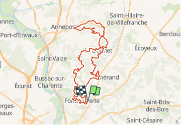
Trail Mountain bike of 42 km to be discovered at New Aquitaine, Charente-Maritime, Fontcouverte. This trail is proposed by tracegps.

Description

Voici une magnifique randonnée organisée le 3 avril 2011 par le club local. On y découvre des paysages surprenants! Dans le département, la Saintonge Romane fait partie des sites se prêtant le mieux à la pratique du VTT. Sur ce parcours de 45km, la dénivelée cumulée est de plus de 1000m. On n’atteint pas souvent ce chiffre en Charente-Maritime! On roule beaucoup en sous-bois, peu sur goudron. Mis à part la distance et la dénivelée, voire quelques passages techniques, la randonnée ne présente pas de grosses difficultés.

Elevation profile

Photos

Positioning

Country:
France
Region :
New Aquitaine
Department/Province :
Charente-Maritime
Municipality :
Fontcouverte
Location:
Unknown
Start:(UTM)
687872 ; 5071431 (30T) N.

Trails nearby

Trail Equestrian La Chapelle-des-Pots - Circuit des potiers - La Chapelle des Pots - Photo
Equestrian
tracegps

Equestrian

Easy
(1)
La Chapelle-des-Pots, New Aquitaine, Charente-Maritime, France
7.2 km | 8.5 km-effort
1h 19min
Yes
Trail Walking La Chapelle-des-Pots - la Chapelle des Pots ( D ROUSSET) - Photo
Walking
Claudinette17

Walking

Medium
(1)
La Chapelle-des-Pots, New Aquitaine, Charente-Maritime, France
7.8 km | 8.8 km-effort
2h 40min
Yes
Trail Walking Chaniers - port huble - Photo
Walking
ninie51

Walking

Medium
Chaniers, New Aquitaine, Charente-Maritime, France
5.6 km | 6.5 km-effort
1h 39min
Yes
Trail Walking La Chapelle-des-Pots - La Chapelle des Pots - Asphodèles - Photo
Walking
Claudinette17

Walking

Easy
(1)
La Chapelle-des-Pots, New Aquitaine, Charente-Maritime, France
7.4 km | 8.7 km-effort
2h 5min
Yes
Trail Other activity Bussac-sur-Charente - Bussac sur Charente - Photo
Other activity
Lessire

Other activity

Very easy
(1)
Bussac-sur-Charente, New Aquitaine, Charente-Maritime, France
11.7 km | 13.6 km-effort
3h 0min
Yes
Trail Walking Saintes - saintes (essais 01) - Photo
Walking
Marcel-le-cycliste

Walking

Very easy
(1)
Saintes, New Aquitaine, Charente-Maritime, France
9 km | 10.4 km-effort
2h 1min
Yes
Trail Walking Saintes - JFT YB Etape11 8-5 -2014  - Photo
Walking
jeff2

Walking

Medium
Saintes, New Aquitaine, Charente-Maritime, France
30 km | 33 km-effort
6h 10min
No
Trail Mountain bike Le Douhet - Circuit des Arches de Fontcouverte - Photo
Mountain bike
tracegps

Mountain bike

Difficult
Le Douhet, New Aquitaine, Charente-Maritime, France
16.5 km | 19.8 km-effort
1h 15min
Yes
Trail Mountain bike La Chapelle-des-Pots - Circuit des potiers - La Chapelle des Pots - Photo
Mountain bike
tracegps

Mountain bike

Easy
La Chapelle-des-Pots, New Aquitaine, Charente-Maritime, France
7.2 km | 8.5 km-effort
34min
Yes


Close
My subscriptions