Trail Walking Ennevelin - GR® 121 b Ancien et nouveau tracé - Ennevelin - Photo

GR® 121 b Ancien et nouveau tracé - Ennevelin

 tracegps
tracegps

User

© OpenStreetMap contributors
Length
Length
24 km
Max alt
Max alt
62 m
Uphill gradient
Uphill gradient
130 m
Km-Effort
Km-Effort  
25 km
Min alt
Min alt
27 m
Downhill gradient
Downhill gradient
129 m
Boucle
Boucle
Yes
Creation date :
2014-12-10 00:00:00.0
Updated on :
2014-12-10 00:00:00.0

(2 Reviews)

Walking
Walking
4h00
Difficulty : Difficult

Scan this QR Code to open this trail in the SityTrail application

FREE GPS app for hiking

Logo SityTrail SityTrail

IGN / Geographical institutes

Download SityTrail from the App Store Download SityTrail from Google Play

Logo SityTrail SityTrail World

The world is yours!

Download SityTrail from the App Store Download SityTrail from Google Play Download SityTrail on Huawei AppGallery

About

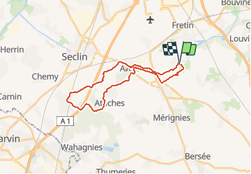
Trail Walking of 24 km to be discovered at Hauts-de-France, Nord, Ennevelin. This trail is proposed by tracegps.

Description

GR® 121 b Ancien et nouveau tracé:24 km 4h . Le nouveau tracé passe par Martinsart beaucoup plus sécurisé et plus pavés, l'ancien lui celui des carte IGN est encore par endroit marqué. cependant il passe par Attiches et Avelin également, les deux sont encore empruntables. Le thème serait les Pavés du Nord. Plus de détail sur www.gomaway.fr.

Elevation profile

Photos

Positioning

Country:
France
Region :
Hauts-de-France
Department/Province :
Nord
Municipality :
Ennevelin
Location:
Unknown
Start:(UTM)
509145 ; 5598650 (31U) N.

Comments

Please log in to post a review or rate the element


Ce tracé (ancien et nouveua GR) n'est plus valable depuis la revalorisation en 2018 du GR 121B. Pour consulter le tracé officiel du GR 121B se rapprocher du Comité Départemental de la Randonnée Pedestre du Nord


Trails nearby

Trail Equestrian Cappelle-en-Pévèle - Boucle des Pavés - Capelle en Pévèle  - Photo
Equestrian
tracegps

Equestrian

Medium
(1)
Cappelle-en-Pévèle, Hauts-de-France, Nord, France
17.7 km | 18.7 km-effort
2h 45min
Yes
Trail Walking Ennevelin - Circuit d'Aigremont - Photo
Walking
tracegps

Walking

Medium
(1)
Ennevelin, Hauts-de-France, Nord, France
11.1 km | 11.8 km-effort
2h 45min
Yes
Trail Walking Péronne-en-Mélantois - Péronne en Mélantois et ses marais - Photo
Walking
tracegps

Walking

Medium
(1)
Péronne-en-Mélantois, Hauts-de-France, Nord, France
13.1 km | 14 km-effort
3h 15min
Yes
Trail Walking Fretin - Mélantois - La Marque - Photo
Walking
Greg813

Walking

Easy
(1)
Fretin, Hauts-de-France, Nord, France
13.9 km | 14.9 km-effort
3h 10min
Yes
Trail Walking Fretin - Sur les traces de Philippe II Auguste - Photo
Walking

Walking

Easy
(1)
Fretin, Hauts-de-France, Nord, France
26 km | 28 km-effort
5h 12min
Yes
Trail Walking Fretin - fretin et ses marais - Photo
Walking
dehemjacques

Walking

Easy
(2)
Fretin, Hauts-de-France, Nord, France
12 km | 12.7 km-effort
2h 31min
Yes
Trail Walking Bouvines - Bouvines 16,2 km - Photo
Walking
GUIDE
rvapeldo

Walking

Easy
Bouvines, Hauts-de-France, Nord, France
16.2 km | 17.3 km-effort
4h 26min
Yes
Trail Walking Avelin - circuit des chicons - Photo
Walking
dehemjacques

Walking

Easy
Avelin, Hauts-de-France, Nord, France
11.7 km | 12.5 km-effort
2h 21min
Yes
Trail On foot Fretin - Fretin - Seclin par le GR121B (option Phalempin) - Photo
On foot

On foot

Medium
Fretin, Hauts-de-France, Nord, France
23 km | 25 km-effort
5h 41min
No


Close
My subscriptions