Trail Mountain bike Bernex - Le Mont Baron - Bernex - Photo
 tracegps
tracegps

User

© OpenStreetMap contributors
Length
Length
18.4 km
Max alt
Max alt
1527 m
Uphill gradient
Uphill gradient
897 m
Km-Effort
Km-Effort  
30 km
Min alt
Min alt
792 m
Downhill gradient
Downhill gradient
894 m
Boucle
Boucle
Yes
Creation date :
2014-12-10 00:00:00.0
Updated on :
2014-12-10 00:00:00.0

(0 Reviews)

Mountain bike
Mountain bike
2h00
Difficulty : Very difficult

Scan this QR Code to open this trail in the SityTrail application

FREE GPS app for hiking

Logo SityTrail SityTrail

IGN / Geographical institutes

Download SityTrail from the App Store Download SityTrail from Google Play

Logo SityTrail SityTrail World

The world is yours!

Download SityTrail from the App Store Download SityTrail from Google Play Download SityTrail on Huawei AppGallery

About

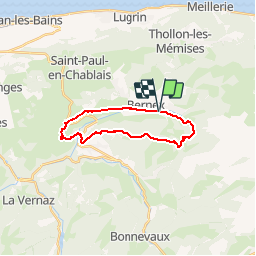
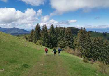
Trail Mountain bike of 18.4 km to be discovered at Auvergne-Rhône-Alpes, Upper Savoy, Bernex. This trail is proposed by tracegps.

Description

Boucle très difficile, nombreux portages mais superbe vue sur les alentours une fois au sommet. Passages techniques par endroit.

Elevation profile

Photos

Positioning

Country:
France
Region :
Auvergne-Rhône-Alpes
Department/Province :
Upper Savoy
Municipality :
Bernex
Location:
Unknown
Start:(UTM)
321847 ; 5136351 (32T) N.

Trails nearby

Trail Walking Bernex - Dent d'Oche - coucher de soleil  - Photo
Walking
dalla.anthony

Walking

Medium
(4)
Bernex, Auvergne-Rhône-Alpes, Upper Savoy, France
9.2 km | 22 km-effort
3h 13min
Yes
Trail Walking Bernex - Boucle depuis Pre Richard.. - Photo
Walking
tyax93

Walking

Medium
Bernex, Auvergne-Rhône-Alpes, Upper Savoy, France
10 km | 19.6 km-effort
4h 46min
Yes
Trail Walking Thollon-les-Mémises - Pic des Mémises-Col de Pertuis-Le Hameau de L’Ain retour Parking - Photo
Walking
Schaff

Walking

Difficult
Thollon-les-Mémises, Auvergne-Rhône-Alpes, Upper Savoy, France
11.4 km | 16.2 km-effort
2h 32min
No
Trail Walking Saint-Paul-en-Chablais - La Chapelle d'Abondance - Photo
Walking
reneperrin

Walking

Easy
Saint-Paul-en-Chablais, Auvergne-Rhône-Alpes, Upper Savoy, France
8.5 km | 11.1 km-effort
2h 0min
Yes
Trail Walking Bernex - Tour du Mont César - Photo
Walking
perenhout

Walking

Medium
Bernex, Auvergne-Rhône-Alpes, Upper Savoy, France
4.4 km | 9.4 km-effort
1h 44min
Yes
Trail Nordic walking Bernex - DENT D OCHE PAR PIC BOLLE  - Photo
Nordic walking
leclaude74

Nordic walking

Difficult
Bernex, Auvergne-Rhône-Alpes, Upper Savoy, France
16 km | 34 km-effort
5h 37min
Yes
Trail Walking Saint-Paul-en-Chablais - lac noir grand tour - Photo
Walking
DMathieu10

Walking

Very easy
(2)
Saint-Paul-en-Chablais, Auvergne-Rhône-Alpes, Upper Savoy, France
6.4 km | 8 km-effort
1h 45min
Yes
Trail Walking Saint-Paul-en-Chablais - Lac Beunez - Photo
Walking
vidal.galaxy

Walking

Medium
(1)
Saint-Paul-en-Chablais, Auvergne-Rhône-Alpes, Upper Savoy, France
11.8 km | 14.9 km-effort
3h 11min
Yes
Trail Walking Bernex - Pic des mémises . colombier par Creusaz  - Photo
Walking
nadd73

Walking

Medium
Bernex, Auvergne-Rhône-Alpes, Upper Savoy, France
8 km | 15.1 km-effort
4h 7min
No


Close
My subscriptions