Trail Walking Cabrespine - Le Mont Sarrat par le col de la Coussièro - Photo

Le Mont Sarrat par le col de la Coussièro

 tracegps
tracegps

User

© OpenStreetMap contributors
Length
Length
10.7 km
Max alt
Max alt
909 m
Uphill gradient
Uphill gradient
700 m
Km-Effort
Km-Effort  
20 km
Min alt
Min alt
310 m
Downhill gradient
Downhill gradient
700 m
Boucle
Boucle
Yes
Creation date :
2014-12-10 00:00:00.0
Updated on :
2014-12-10 00:00:00.0

(1 Reviews)

Walking
Walking
4h00
Difficulty : Difficult

Scan this QR Code to open this trail in the SityTrail application

FREE GPS app for hiking

Logo SityTrail SityTrail

IGN / Geographical institutes

Download SityTrail from the App Store Download SityTrail from Google Play

Logo SityTrail SityTrail World

The world is yours!

Download SityTrail from the App Store Download SityTrail from Google Play Download SityTrail on Huawei AppGallery

About

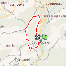
Trail Walking of 10.7 km to be discovered at Occitania, Aude, Cabrespine. This trail is proposed by tracegps.

Description

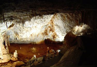
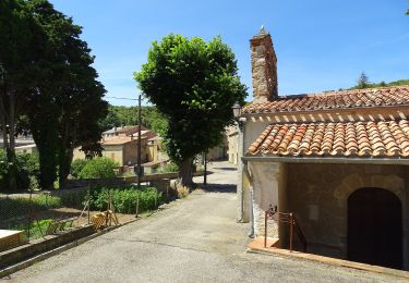
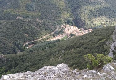
Circuit sportif de mise en jambe pour futures sorties montagnes. De Cabrespine et son château en ruine (beau point de vue sur le village et sa vallée) vous allez suivre une crête escarpée et rocheuse étonnante, mal balisée, jusqu'au mont Sarrat qui vous rappellera à coup sûr vos sorties de haute montagne. La boucle fait 11km et 800m de D  sur 4 km, le retour se faisant par le GR 36 et l'entrée du célèbre gouffre de Cabrespine. Par temps clair vous aurez une vue exceptionnelle de la moitié de la chaîne pyrénéenne ainsi que de la presque totalité du département de l'Aude.

Elevation profile

Positioning

Country:
France
Region :
Occitania
Department/Province :
Aude
Municipality :
Cabrespine
Location:
Unknown
Start:(UTM)
456313 ; 4801213 (31T) N.

Comments

Please log in to post a review or rate the element


Trails nearby

Trail Walking Castans - Boucle des ruisseaux - Castans - Photo
Walking
tracegps

Walking

Medium
(5)
Castans, Occitania, Aude, France
6.4 km | 10 km-effort
4h 0min
Yes
Trail On foot Cabrespine - Les Villages Perchés - Photo
On foot
PRO

On foot

Easy
Cabrespine, Occitania, Aude, France
8.3 km | 14.7 km-effort
3h 21min
No
Trail On foot Cabrespine - Boucle du Gouffre de Cabrespine - Photo
On foot
PRO

On foot

Easy
Cabrespine, Occitania, Aude, France
4.9 km | 8.7 km-effort
1h 59min
No
Trail Walking Villeneuve-Minervois - pujol de bosc castanviel - Photo
Walking
henribatut

Walking

Easy
Villeneuve-Minervois, Occitania, Aude, France
15.9 km | 23 km-effort
5h 20min
Yes
Trail Walking Sallèles-Cabardès - Sallèles Cabardès - Pradellles Cabardès - Pic du Nore-   - Photo
Walking
jacques delaporte

Walking

Very difficult
Sallèles-Cabardès, Occitania, Aude, France
65 km | 0 m-effort
23h 36min
Yes
Trail Walking Sallèles-Cabardès - Reco Le Pic de Nore  - Photo
Walking
jacques delaporte

Walking

Very difficult
Sallèles-Cabardès, Occitania, Aude, France
54 km | 79 km-effort
21h 27min
Yes
Trail Walking Limousis - Limousis  - Photo
Walking
Christophe Ferreres

Walking

Difficult
Limousis, Occitania, Aude, France
9.8 km | 14.9 km-effort
3h 48min
Yes
Trail Walking Limousis - Mont Simel  - Photo
Walking
bernardbelmas

Walking

Medium
Limousis, Occitania, Aude, France
9.6 km | 13.9 km-effort
3h 39min
Yes
Trail On foot Pradelles-Cabardès - Pradelles,roc de l'aigle,cabrespine,pradelles - Photo
On foot
Dupleix

On foot

Difficult
Pradelles-Cabardès, Occitania, Aude, France
15.3 km | 24 km-effort
5h 50min
Yes


Close
My subscriptions