Trail Walking Champrond-en-Perchet - Champrond en Perchet - Photo
 tracegps
tracegps

User

© OpenStreetMap contributors
Length
Length
8.1 km
Max alt
Max alt
220 m
Uphill gradient
Uphill gradient
109 m
Km-Effort
Km-Effort  
9.6 km
Min alt
Min alt
160 m
Downhill gradient
Downhill gradient
116 m
Boucle
Boucle
Yes
Creation date :
2014-12-10 00:00:00.0
Updated on :
2014-12-10 00:00:00.0

(0 Reviews)

Walking
Walking
1h30
Difficulty : Easy

Scan this QR Code to open this trail in the SityTrail application

FREE GPS app for hiking

Logo SityTrail SityTrail

IGN / Geographical institutes

Download SityTrail from the App Store Download SityTrail from Google Play

Logo SityTrail SityTrail World

The world is yours!

Download SityTrail from the App Store Download SityTrail from Google Play Download SityTrail on Huawei AppGallery

About

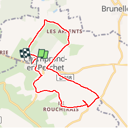
Trail Walking of 8.1 km to be discovered at Centre-Loire Valley, Eure-et-Loir, Champrond-en-Perchet. This trail is proposed by tracegps.

Description

Aucunes difficultés particulières. Peu de chemins de terre boueux en cas de pluie. La tranquillité, le calme...

Elevation profile

Photos

Positioning

Country:
France
Region :
Centre-Loire Valley
Department/Province :
Eure-et-Loir
Municipality :
Champrond-en-Perchet
Location:
Unknown
Start:(UTM)
341730 ; 5353082 (31U) N.

Trails nearby

Trail Walking Trizay-Coutretot-Saint-Serge - Trizay 100-B - Photo
Walking
togolo28

Walking

Difficult
(2)
Trizay-Coutretot-Saint-Serge, Centre-Loire Valley, Eure-et-Loir, France
48 km | 56 km-effort
12h 1min
Yes
Trail Walking Arcisses - Coudreceau, les panoramas du Perche Eurélien 9,4 km - Photo
Walking
ODDAD78

Walking

Medium
Arcisses, Centre-Loire Valley, Eure-et-Loir, France
9.4 km | 11.4 km-effort
2h 35min
Yes
Trail Walking Vichères - Vichères - la colline de Rougemont 8 km - Photo
Walking
ODDAD78

Walking

Medium
Vichères, Centre-Loire Valley, Eure-et-Loir, France
8 km | 10.3 km-effort
2h 20min
Yes
Trail Walking Arcisses - Brunelles - Autour du Promontoire 10 km - Photo
Walking
ODDAD78

Walking

Medium
Arcisses, Centre-Loire Valley, Eure-et-Loir, France
10.1 km | 11.6 km-effort
2h 37min
Yes
Trail Walking Nogent-le-Rotrou - NOGENT LE ROTROU - Photo
Walking
jeannine grandjean

Walking

Medium
Nogent-le-Rotrou, Centre-Loire Valley, Eure-et-Loir, France
5.8 km | 6.9 km-effort
1h 33min
Yes
Trail Walking Arcisses - 2023-04-24_20h15m45_Ozée  9,1 km - Photo
Walking
ODDAD78

Walking

Medium
(1)
Arcisses, Centre-Loire Valley, Eure-et-Loir, France
9.1 km | 11.2 km-effort
2h 32min
Yes
Trail Walking La Gaudaine - La Gaudaine - les panoramas 12 km - Photo
Walking
ODDAD78

Walking

Easy
La Gaudaine, Centre-Loire Valley, Eure-et-Loir, France
11.9 km | 14.9 km-effort
5min
Yes
Trail Walking Nogent-le-Rotrou - SityTrail - Nogent-le-Rotrou - Saint-Victor-de-Buthon 19 km - Photo
Walking

Walking

Very difficult
Nogent-le-Rotrou, Centre-Loire Valley, Eure-et-Loir, France
19 km | 23 km-effort
5h 5min
No
Trail Walking Nogent-le-Rotrou - 10981160-ZProjet Nogent - Thiron 2 - Photo
Walking

Walking

Very difficult
Nogent-le-Rotrou, Centre-Loire Valley, Eure-et-Loir, France
22 km | 26 km-effort
6h 0min
No


Close
My subscriptions