Trail Walking Aulnois-sous-Laon - Les monts fendus - Photo
 tracegps
tracegps

User

© OpenStreetMap contributors
Length
Length
22 km
Max alt
Max alt
103 m
Uphill gradient
Uphill gradient
133 m
Km-Effort
Km-Effort  
23 km
Min alt
Min alt
64 m
Downhill gradient
Downhill gradient
133 m
Boucle
Boucle
Yes
Creation date :
2014-12-10 00:00:00.0
Updated on :
2014-12-10 00:00:00.0

(0 Reviews)

Walking
Walking
6h00
Difficulty : Unknown

Scan this QR Code to open this trail in the SityTrail application

FREE GPS app for hiking

Logo SityTrail SityTrail

IGN / Geographical institutes

Download SityTrail from the App Store Download SityTrail from Google Play

Logo SityTrail SityTrail World

The world is yours!

Download SityTrail from the App Store Download SityTrail from Google Play Download SityTrail on Huawei AppGallery

About

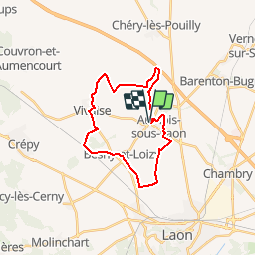
Trail Walking of 22 km to be discovered at Hauts-de-France, Aisne, Aulnois-sous-Laon. This trail is proposed by tracegps.

Description

Au royaume de la betterave à sucre, ce circuit contourne les buttes-témoins qui se dressent en avant-garde du plateau d'Ile-de-France. Toutes les infos sont ICI

Elevation profile

Photos

Positioning

Country:
France
Region :
Hauts-de-France
Department/Province :
Aisne
Municipality :
Aulnois-sous-Laon
Location:
Unknown
Start:(UTM)
543437 ; 5495969 (31U) N.

Trails nearby

Trail Other activity Laon - Picardie - Ligne 228 - Laon - Liart - Photo
Other activity
mich54

Other activity

Very easy
Laon, Hauts-de-France, Aisne, France
59 km | 65 km-effort
5min
No
Trail Walking Aulnois-sous-Laon - Les monts fendus  - variante - Photo
Walking
tracegps

Walking

Very difficult
Aulnois-sous-Laon, Hauts-de-France, Aisne, France
13.6 km | 14.8 km-effort
3h 0min
Yes
Trail Walking Laon - Rando découverte de Laon - Photo
Walking
benoit92320

Walking

Medium
Laon, Hauts-de-France, Aisne, France
16.8 km | 21 km-effort
Unknown
No


Close
My subscriptions