Trail Walking Saint-Paul-d'Oueil - caps de Salière et de la Coume de Mourdere  - Photo

caps de Salière et de la Coume de Mourdere

 chrisgps
chrisgps

User

© OpenStreetMap contributors
Length
Length
11.4 km
Max alt
Max alt
1827 m
Uphill gradient
Uphill gradient
730 m
Km-Effort
Km-Effort  
21 km
Min alt
Min alt
1127 m
Downhill gradient
Downhill gradient
730 m
Boucle
Boucle
Yes
Creation date :
2019-05-08 15:16:06.192
Updated on :
2019-05-08 15:16:06.323

(1 Reviews)

Walking
Walking
5h54
Difficulty : Medium

Scan this QR Code to open this trail in the SityTrail application

FREE GPS app for hiking

Logo SityTrail SityTrail

IGN / Geographical institutes

Download SityTrail from the App Store Download SityTrail from Google Play

Logo SityTrail SityTrail World

The world is yours!

Download SityTrail from the App Store Download SityTrail from Google Play Download SityTrail on Huawei AppGallery

About

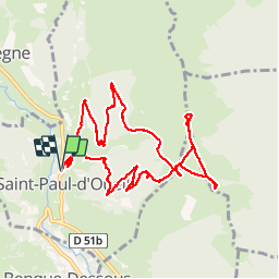
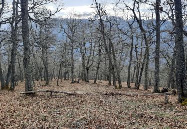
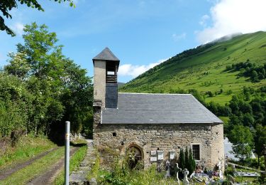
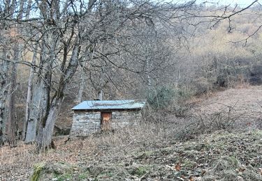
Trail Walking of 11.4 km to be discovered at Occitania, Haute-Garonne, Saint-Paul-d'Oueil. This trail is proposed by chrisgps.

Description

en boucle depuis st paul d'oueil

Elevation profile

Photos

Positioning

Country:
France
Region :
Occitania
Department/Province :
Haute-Garonne
Municipality :
Saint-Paul-d'Oueil
Location:
Unknown
Start:(UTM)
299809 ; 4744831 (31T) N.

Comments

Please log in to post a review or rate the element


Trails nearby

Trail Snowshoes Juzet-de-Luchon - JUZET - PAS DE LA COMBE (LABACH) - Photo
Snowshoes
Marcocroco

Snowshoes

Medium
(1)
Juzet-de-Luchon, Occitania, Haute-Garonne, France
7.1 km | 12.5 km-effort
2h 33min
Yes
Trail Walking Bourg-d'Oueil - Le Mont Né - Photo
Walking
tracegps

Walking

Very difficult
(1)
Bourg-d'Oueil, Occitania, Haute-Garonne, France
8.9 km | 19.6 km-effort
5h 0min
Yes
Trail Walking Saccourvielle - Cap de Salières en boucle depuis Saccourvielle - Photo
Walking
GUIDE
lhomme.ph

Walking

Medium
Saccourvielle, Occitania, Haute-Garonne, France
12.1 km | 24 km-effort
6h 23min
Yes
Trail Walking Bagnères-de-Luchon - GR 10 - 3 - Photo
Walking
loic09

Walking

Medium
(2)
Bagnères-de-Luchon, Occitania, Haute-Garonne, France
250 km | 489 km-effort
89h 8min
No
Trail Walking Mayrègne - mail de la pène de Rustier en boucle depuis Mayrègne  - Photo
Walking
GUIDE
lhomme.ph

Walking

Medium
Mayrègne, Occitania, Haute-Garonne, France
11.7 km | 21 km-effort
6h 2min
Yes
Trail Walking Saint-Aventin - Cabane de Courreau en boucle depuis St Aventin  - Photo
Walking
GUIDE
lhomme.ph

Walking

Medium
Saint-Aventin, Occitania, Haute-Garonne, France
13.3 km | 24 km-effort
6h 10min
Yes
Trail Walking Mayrègne - Cap de Serrède en boucle depuis Mayrègne  - Photo
Walking
GUIDE
lhomme.ph

Walking

Medium
Mayrègne, Occitania, Haute-Garonne, France
6.6 km | 15.2 km-effort
4h 11min
Yes
Trail On foot Benque-Dessous-et-Dessus - Boucle dans la vallée du Larboust et la Vallée d'Oueil - Photo
On foot
PRO

On foot

Easy
Benque-Dessous-et-Dessus, Occitania, Haute-Garonne, France
4.9 km | 8.7 km-effort
1h 58min
No
Trail Walking Oô - Cap des Arjoulents (finalement pas fait !)  & Cabane de Turon - Photo
Walking
chrisgps

Walking

Easy
Oô, Occitania, Haute-Garonne, France
15.4 km | 25 km-effort
7h 3min
Yes


Close
My subscriptions