Trail Walking Bagnères-de-Luchon - GR 10 - 3 - Photo
 loic09
loic09

User

© OpenStreetMap contributors
Length
Length
250 km
Max alt
Max alt
2428 m
Uphill gradient
Uphill gradient
17980 m
Km-Effort
Km-Effort  
489 km
Min alt
Min alt
535 m
Downhill gradient
Downhill gradient
17556 m
Boucle
Boucle
No
Creation date :
2014-12-10 00:00:00.0
Updated on :
2014-12-10 00:00:00.0

(2 Reviews)

Walking
Walking
89h08
Difficulty : Medium

Scan this QR Code to open this trail in the SityTrail application

FREE GPS app for hiking

Logo SityTrail SityTrail

IGN / Geographical institutes

Download SityTrail from the App Store Download SityTrail from Google Play

Logo SityTrail SityTrail World

The world is yours!

Download SityTrail from the App Store Download SityTrail from Google Play Download SityTrail on Huawei AppGallery

About

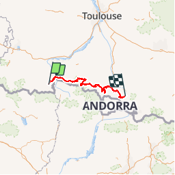
Trail Walking of 250 km to be discovered at Occitania, Haute-Garonne, Bagnères-de-Luchon. This trail is proposed by loic09.

Description

De Bagnères de Luchon à Merens les vals

Elevation profile

Positioning

Country:
France
Region :
Occitania
Department/Province :
Haute-Garonne
Municipality :
Bagnères-de-Luchon
Location:
Unknown
Start:(UTM)
302976 ; 4740465 (31T) N.

Comments

Please log in to post a review or rate the element


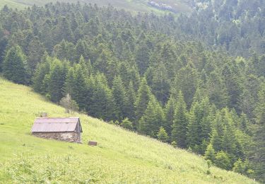
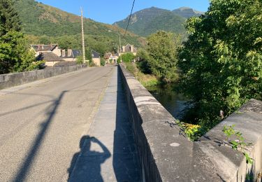
Guide clair et facile à suivre grâce au tracé GPS. Chemin GR10 bien balisé et parfait pour un randonneur. Beaux paysages. En 1 mot : SUPER.


Trails nearby

Trail Snowshoes Juzet-de-Luchon - JUZET - PAS DE LA COMBE (LABACH) - Photo
Snowshoes
Marcocroco

Snowshoes

Medium
(1)
Juzet-de-Luchon, Occitania, Haute-Garonne, France
7.1 km | 12.5 km-effort
2h 33min
Yes
Trail Walking Saint-Mamet - Fonds de Burbe - Saint Mamet - Photo
Walking
tracegps

Walking

Difficult
(1)
Saint-Mamet, Occitania, Haute-Garonne, France
15.6 km | 27 km-effort
4h 0min
Yes
Trail Mountain bike Saint-Aventin - Luchon Kbour - Photo
Mountain bike
tracegps

Mountain bike

Very difficult
(1)
Saint-Aventin, Occitania, Haute-Garonne, France
11 km | 16.7 km-effort
1h 0min
No
Trail Walking Saccourvielle - Cap de Salières en boucle depuis Saccourvielle - Photo
Walking
GUIDE
lhomme.ph

Walking

Medium
Saccourvielle, Occitania, Haute-Garonne, France
12.1 km | 24 km-effort
6h 23min
Yes
Trail Walking Artigue - ARTIGUE - Gouaux de Luchon - chemin forestier - Photo
Walking
josy31

Walking

Medium
(1)
Artigue, Occitania, Haute-Garonne, France
13.7 km | 23 km-effort
3h 21min
Yes
Trail Walking Saint-Aventin - Cabane de Courreau en boucle depuis St Aventin  - Photo
Walking
GUIDE
lhomme.ph

Walking

Medium
Saint-Aventin, Occitania, Haute-Garonne, France
13.3 km | 24 km-effort
6h 10min
Yes
Trail Walking Artigue - Artigue par la cabane du plan Bosc et la cabane de Saunères - Photo
Walking
swp648

Walking

Difficult
Artigue, Occitania, Haute-Garonne, France
10.5 km | 18.3 km-effort
4h 10min
Yes
Trail Walking Bagnères-de-Luchon - 2022 08 -Transpyrénéen 2 : Bagnères de Luchon -Fos - Photo
Walking
LEGUE

Walking

Very difficult
Bagnères-de-Luchon, Occitania, Haute-Garonne, France
30 km | 55 km-effort
7h 8min
No
Trail Walking Artigue - 2022-02-26 Artigue - cabane de peyrehitte - mont Majou -  luchonais - Photo
Walking
jacq58

Walking

Difficult
Artigue, Occitania, Haute-Garonne, France
12 km | 22 km-effort
3h 33min
Yes


Close
My subscriptions