Trail Walking Bidarray - De Bidarray à Saint Etienne de Baïgorry - Photo

De Bidarray à Saint Etienne de Baïgorry

 tracegps
tracegps

User

© OpenStreetMap contributors
Length
Length
17.7 km
Max alt
Max alt
1036 m
Uphill gradient
Uphill gradient
1271 m
Km-Effort
Km-Effort  
34 km
Min alt
Min alt
79 m
Downhill gradient
Downhill gradient
1194 m
Boucle
Boucle
No
Creation date :
2014-12-10 00:00:00.0
Updated on :
2014-12-10 00:00:00.0

(0 Reviews)

Walking
Walking
7h00
Difficulty : Difficult

Scan this QR Code to open this trail in the SityTrail application

FREE GPS app for hiking

Logo SityTrail SityTrail

IGN / Geographical institutes

Download SityTrail from the App Store Download SityTrail from Google Play

Logo SityTrail SityTrail World

The world is yours!

Download SityTrail from the App Store Download SityTrail from Google Play Download SityTrail on Huawei AppGallery

About

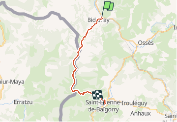
Trail Walking of 17.7 km to be discovered at New Aquitaine, Pyrénées-Atlantiques, Bidarray. This trail is proposed by tracegps.

Description

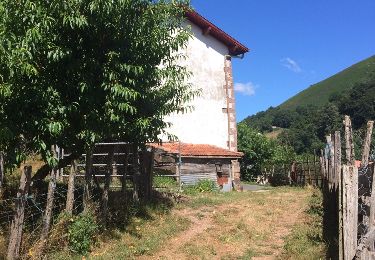
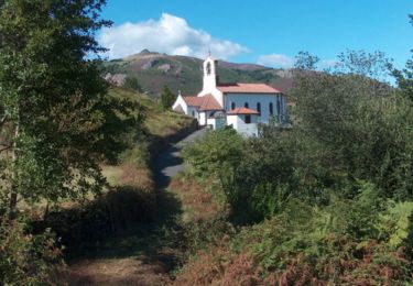
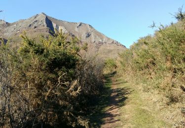
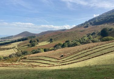
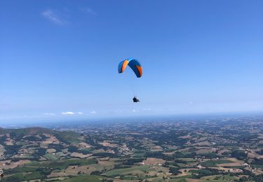
De Bidarray à Saint Etienne de Baïgorry. Magnifique randonnée le long d’une ligne de crêtes entre vallées de la Nive et du Bastan. Choisir un temps sec et clair pour bénéficier du panorama jusqu’au Pic du Midi de Bigorre et pour progresser en sécurité le long d’à-pics vertigineux et sur des versants herbeux très raides. Pied montagnard requis. Téléchargez la carte et le descriptif de cette randonnée. Retrouvez d’autres itinéraires de rando sur le site Rando 64.

Elevation profile

Photos

Positioning

Country:
France
Region :
New Aquitaine
Department/Province :
Pyrénées-Atlantiques
Municipality :
Bidarray
Location:
Unknown
Start:(UTM)
634316 ; 4791979 (30T) N.

Trails nearby

Trail Walking Ossès - haltzamendi - Photo
Walking
jcaudron

Walking

Very easy
(1)
Ossès, New Aquitaine, Pyrénées-Atlantiques, France
14.5 km | 26 km-effort
5h 13min
Yes
Trail Walking Saint-Martin-d'Arrossa - 2023-05-31_09h58m49_st-martin-d-arrossa-larla-sentier-des-mines - Photo
Walking
Geo40 caching

Walking

Difficult
(1)
Saint-Martin-d'Arrossa, New Aquitaine, Pyrénées-Atlantiques, France
9.7 km | 16 km-effort
3h 38min
Yes
Trail Walking Bidarray - Peñas d'Itxusi - Photo
Walking
laureberger1

Walking

Easy
(2)
Bidarray, New Aquitaine, Pyrénées-Atlantiques, France
11 km | 19.5 km-effort
3h 25min
Yes
Trail Walking Saint-Martin-d'Arrossa - Sommet de Larla en boucle de Saint Martin d'Arrossa - Photo
Walking
tracegps

Walking

Difficult
(2)
Saint-Martin-d'Arrossa, New Aquitaine, Pyrénées-Atlantiques, France
9.5 km | 15.9 km-effort
4h 0min
Yes
Trail Walking Itxassou - L'ARTZAMENDI - Photo
Walking
benat40

Walking

Easy
(1)
Itxassou, New Aquitaine, Pyrénées-Atlantiques, France
8.3 km | 18.8 km-effort
Unknown
Yes
Trail Walking Baztan - BIDARAY  le village abandonné d'Iratzakun G3 - Photo
Walking
GUIDE
marmotte65

Walking

Very difficult
Baztan, Navarre, Unknown, Spain
11.8 km | 15.9 km-effort
4h 8min
Yes
Trail Walking Macaye - Mont Baigura  - Photo
Walking
GUIDE
antignacs

Walking

Medium
Macaye, New Aquitaine, Pyrénées-Atlantiques, France
14.6 km | 27 km-effort
5h 9min
Yes
Trail Walking Macaye - Baigura en Boucle 31/07/2022 - Photo
Walking
jaja64

Walking

Medium
Macaye, New Aquitaine, Pyrénées-Atlantiques, France
12.4 km | 22 km-effort
4h 53min
Yes
Trail Walking Saint-Martin-d'Arrossa - Chemin des mineurs  - Photo
Walking
RVMASSON

Walking

Medium
(1)
Saint-Martin-d'Arrossa, New Aquitaine, Pyrénées-Atlantiques, France
9.7 km | 16 km-effort
3h 23min
Yes


Close
My subscriptions