Trail Walking Albertville - D'Albertville à Thônes 1/4 - Autour de la Belle Etoile - Photo

D'Albertville à Thônes 1/4 - Autour de la Belle Etoile

 tracegps
tracegps

User

© OpenStreetMap contributors
Length
Length
18 km
Max alt
Max alt
1066 m
Uphill gradient
Uphill gradient
1166 m
Km-Effort
Km-Effort  
32 km
Min alt
Min alt
342 m
Downhill gradient
Downhill gradient
668 m
Boucle
Boucle
No
Creation date :
2014-12-10 00:00:00.0
Updated on :
2014-12-10 00:00:00.0

(0 Reviews)

Walking
Walking
6h30
Difficulty : Difficult

Scan this QR Code to open this trail in the SityTrail application

FREE GPS app for hiking

Logo SityTrail SityTrail

IGN / Geographical institutes

Download SityTrail from the App Store Download SityTrail from Google Play

Logo SityTrail SityTrail World

The world is yours!

Download SityTrail from the App Store Download SityTrail from Google Play Download SityTrail on Huawei AppGallery

About

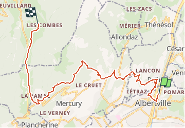
Trail Walking of 18 km to be discovered at Auvergne-Rhône-Alpes, Savoy, Albertville. This trail is proposed by tracegps.

Description

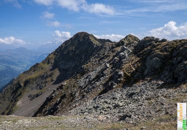
D'Albertville à Thônes 1/4 - Autour de la Belle Etoile. La première étape de notre périple, un départ d'Alberville pour rejoindre le camping du hameau "Les combes" sur la commune de Seythenex. L'objectif de notre journée est d'éviter les orages qui sévissent :'( Plutôt que de gravie la Belle Etoile comme prévu, nous décidons de la contourner par le Collet de Tamié pour rester à l'abri de la forêt sur les flancs de la montagne. Un peu décevant pour une première étape mais elle nous a au moins permis une bonne mise en jambe. Retrouvez toutes les informations nécessaires sur le site de la Communauté des Crapahuteurs.

Elevation profile

Photos

Positioning

Country:
France
Region :
Auvergne-Rhône-Alpes
Department/Province :
Savoy
Municipality :
Albertville
Location:
Unknown
Start:(UTM)
297227 ; 5061770 (32T) N.

Trails nearby

Trail Walking Queige - Le sentier de la mémoire - Les Pointières - Photo
Walking
tracegps

Walking

Medium
(1)
Queige, Auvergne-Rhône-Alpes, Savoy, France
5.1 km | 8.9 km-effort
3h 0min
Yes
Trail Motor Albertville - azéri - Photo
Motor
gpiou

Motor

Very easy
(1)
Albertville, Auvergne-Rhône-Alpes, Savoy, France
51 km | 60 km-effort
1h 57min
No
Trail Other activity Mercury - très vite - Photo
Other activity
arnaud.thery

Other activity

Very easy
Mercury, Auvergne-Rhône-Alpes, Savoy, France
31 km | 63 km-effort
2h 56min
No
Trail Cycle Albertville - Hardy L'Arly - Photo
Cycle
biollay

Cycle

Difficult
Albertville, Auvergne-Rhône-Alpes, Savoy, France
45 km | 65 km-effort
Unknown
No
Trail Snowshoes Queige - Le Haut du Pré depuis le parking des Croix - Photo
Snowshoes
ilur56

Snowshoes

Medium
Queige, Auvergne-Rhône-Alpes, Savoy, France
7.1 km | 14.5 km-effort
2h 42min
Yes
Trail Walking Albertville - alberville  - Photo
Walking
Bugeat

Walking

Very easy
Albertville, Auvergne-Rhône-Alpes, Savoy, France
10.8 km | 22 km-effort
6h 37min
Yes
Trail Walking Queige - La Roche Pourrie depuis les Chappes - Photo
Walking
tracegps

Walking

Difficult
Queige, Auvergne-Rhône-Alpes, Savoy, France
4.3 km | 10.3 km-effort
3h 4min
Yes
Trail Walking Venthon - Traversée de la Roche Pourrie, Mont Mirantin, 2460m - Photo
Walking
tracegps

Walking

Difficult
Venthon, Auvergne-Rhône-Alpes, Savoy, France
15.4 km | 33 km-effort
9h 30min
Yes
Trail Walking Queige - Le sentier de la mémoire - Les Pointières - Photo
Walking
GUIDE
Desrumaux

Walking

Easy
Queige, Auvergne-Rhône-Alpes, Savoy, France
5.1 km | 8.9 km-effort
3h 0min
Yes


Close
My subscriptions