Trail Walking Merckeghem - Sentier de l'Eekhout Veld - Merckeghem - Photo

Sentier de l'Eekhout Veld - Merckeghem

 tracegps
tracegps

User

© OpenStreetMap contributors
Length
Length
7.3 km
Max alt
Max alt
57 m
Uphill gradient
Uphill gradient
81 m
Km-Effort
Km-Effort  
8.4 km
Min alt
Min alt
-1 m
Downhill gradient
Downhill gradient
81 m
Boucle
Boucle
Yes
Creation date :
2014-12-10 00:00:00.0
Updated on :
2014-12-10 00:00:00.0

(1 Reviews)

Walking
Walking
2h00
Difficulty : Medium

Scan this QR Code to open this trail in the SityTrail application

FREE GPS app for hiking

Logo SityTrail SityTrail

IGN / Geographical institutes

Download SityTrail from the App Store Download SityTrail from Google Play

Logo SityTrail SityTrail World

The world is yours!

Download SityTrail from the App Store Download SityTrail from Google Play Download SityTrail on Huawei AppGallery

About

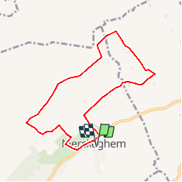
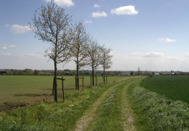
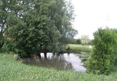
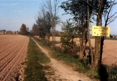
Trail Walking of 7.3 km to be discovered at Hauts-de-France, Nord, Merckeghem. This trail is proposed by tracegps.

Description

Départ de l’Eglise de Merckeghem Circuit pittoresque permettant de découvrir en bas l'ancien talus maritime. A parcourir toute l'année, cet itinéraire emprunte des petites routes de campagne et des sentiers bordés de haies et de chemins agricoles. Retrouvez cette randonnée sur le site du Comité Départemental du Tourisme du Nord.

Elevation profile

Photos

Positioning

Country:
France
Region :
Hauts-de-France
Department/Province :
Nord
Municipality :
Merckeghem
Location:
Unknown
Start:(UTM)
450496 ; 5634619 (31U) N.

Comments

Please log in to post a review or rate the element


Trails nearby

Trail Cycle Merckeghem - Boucle de Merckeghem - Photo
Cycle
tracegps

Cycle

Medium
Merckeghem, Hauts-de-France, Nord, France
29 km | 31 km-effort
2h 0min
Yes
Trail Cycle Volckerinckhove - Boucle de Volckerinckhove - Photo
Cycle
tracegps

Cycle

Easy
Volckerinckhove, Hauts-de-France, Nord, France
29 km | 31 km-effort
1h 30min
Yes
Trail Walking Bollezeele - Circuit du Pantgat - Bollezeele - Photo
Walking
tracegps

Walking

Easy
Bollezeele, Hauts-de-France, Nord, France
6.4 km | 7.1 km-effort
1h 40min
Yes
Trail Walking Rubrouck - Circuit des mares - Rubrouck - Photo
Walking
tracegps

Walking

Medium
Rubrouck, Hauts-de-France, Nord, France
10 km | 10.4 km-effort
2h 30min
Yes
Trail Walking Volckerinckhove - Volckerinckhove - Village Patrimoine - Photo
Walking
tracegps

Walking

Easy
Volckerinckhove, Hauts-de-France, Nord, France
6.2 km | 6.9 km-effort
1h 30min
Yes
Trail Walking Volckerinckhove - Autour de Sainte-Mildrede (Volckerinckhove) - Photo
Walking
tracegps

Walking

Medium
(1)
Volckerinckhove, Hauts-de-France, Nord, France
8.9 km | 10 km-effort
2h 15min
Yes
Trail Cycle Broxeele - Les Rives de l'Yser 4 - Broxeele - Photo
Cycle
tracegps

Cycle

Medium
Broxeele, Hauts-de-France, Nord, France
27 km | 29 km-effort
2h 0min
Yes
Trail Cycle Bollezeele - Les Rives de l'Yser 3 - Bollezeele - Photo
Cycle
tracegps

Cycle

Medium
(1)
Bollezeele, Hauts-de-France, Nord, France
39 km | 42 km-effort
3h 0min
Yes
Trail Walking Rubrouck - Rubrouck - Village Patrimoine - Photo
Walking
tracegps

Walking

Easy
Rubrouck, Hauts-de-France, Nord, France
1.4 km | 1.5 km-effort
25min
Yes


Close
My subscriptions