Trail Mountain bike Caudecoste - Caudecoste, une bastide du 13ème siècle - Pays de l'Agenais - Photo

Caudecoste, une bastide du 13ème siècle - Pays de l'Agenais

 tracegps
tracegps

User

© OpenStreetMap contributors
Length
Length
4.3 km
Max alt
Max alt
113 m
Uphill gradient
Uphill gradient
70 m
Km-Effort
Km-Effort  
5.2 km
Min alt
Min alt
55 m
Downhill gradient
Downhill gradient
69 m
Boucle
Boucle
Yes
Creation date :
2014-12-10 00:00:00.0
Updated on :
2014-12-10 00:00:00.0

(0 Reviews)

Mountain bike
Mountain bike
34m
Difficulty : Easy

Scan this QR Code to open this trail in the SityTrail application

FREE GPS app for hiking

Logo SityTrail SityTrail

IGN / Geographical institutes

Download SityTrail from the App Store Download SityTrail from Google Play

Logo SityTrail SityTrail World

The world is yours!

Download SityTrail from the App Store Download SityTrail from Google Play Download SityTrail on Huawei AppGallery

About

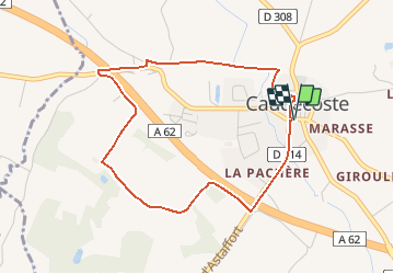
Trail Mountain bike of 4.3 km to be discovered at New Aquitaine, Lot-et-Garonne, Caudecoste. This trail is proposed by tracegps.

Description

Suspension provisoire : cause entretien. Caudecoste Communauté de Communes d’Astaffort en Brulhois Ce petit circuit, au départ d’une bastide typique de ces villages bâtis aux 13ème et 14ème siècles, n’offre aucune difficulté, mais demande une grande vigilance lors des deux passages sur des voies départementales. Vignobles du Brulhois et vergers de pruniers d’Ente se partagent l’espace cultivé. Téléchargez la fiche de cette randonnée sur le site du Tourisme du Lot et Garonne.

Elevation profile

Photos

Positioning

Country:
France
Region :
New Aquitaine
Department/Province :
Lot-et-Garonne
Municipality :
Caudecoste
Location:
Unknown
Start:(UTM)
318899 ; 4887179 (31T) N.

Trails nearby

Trail Mountain bike Sauveterre-Saint-Denis - Sauveterre St Denis - Photo
Mountain bike
tracegps

Mountain bike

Medium
Sauveterre-Saint-Denis, New Aquitaine, Lot-et-Garonne, France
30 km | 34 km-effort
2h 0min
Yes
Trail Walking Sauveterre-Saint-Denis - Sauveterre St Denis - Photo
Walking
tracegps

Walking

Very difficult
Sauveterre-Saint-Denis, New Aquitaine, Lot-et-Garonne, France
30 km | 34 km-effort
6h 0min
Yes
Trail Mountain bike Saint-Jean-de-Thurac - Saint-Jean-de-Thurac, du canal aux coteaux de Serres - Pays de l'Agenais - Photo
Mountain bike
tracegps

Mountain bike

Medium
Saint-Jean-de-Thurac, New Aquitaine, Lot-et-Garonne, France
7.1 km | 9.9 km-effort
1h 10min
Yes
Trail Walking Saint-Jean-de-Thurac - Saint-Jean-de-Thurac, du canal aux coteaux de Serres - Pays de l'Agenais - Photo
Walking
tracegps

Walking

Medium
Saint-Jean-de-Thurac, New Aquitaine, Lot-et-Garonne, France
7.1 km | 9.9 km-effort
2h 15min
Yes
Trail Equestrian Cuq - Cuq / Fals, un circuit de randonnée en Gascogne - Pays de l'Agenais - Photo
Equestrian
tracegps

Equestrian

Medium
Cuq, New Aquitaine, Lot-et-Garonne, France
12.5 km | 16.5 km-effort
2h 10min
Yes
Trail Mountain bike Cuq - Cuq / Fals, un circuit de randonnée en Gascogne - Pays de l'Agenais - Photo
Mountain bike
tracegps

Mountain bike

Medium
Cuq, New Aquitaine, Lot-et-Garonne, France
12.5 km | 16.5 km-effort
1h 40min
Yes
Trail Walking Cuq - Cuq / Fals, un circuit de randonnée en Gascogne - Pays de l'Agenais - Photo
Walking
tracegps

Walking

Medium
Cuq, New Aquitaine, Lot-et-Garonne, France
12.5 km | 16.5 km-effort
3h 15min
Yes
Trail Walking Caudecoste - Caudecoste, une bastide du 13ème siècle - Pays de l'Agenais - Photo
Walking
tracegps

Walking

Easy
Caudecoste, New Aquitaine, Lot-et-Garonne, France
4.3 km | 5.2 km-effort
1h 30min
Yes
Trail Walking Fals - Fals 25 04 22 - Photo
Walking
mdns

Walking

Medium
Fals, New Aquitaine, Lot-et-Garonne, France
8.5 km | 10.8 km-effort
3h 34min
Yes


Close
My subscriptions