Trail Walking Layrac - Layrac, une randonnée dans la vallée du Gers - Pays de l'Agenais - Photo

Layrac, une randonnée dans la vallée du Gers - Pays de l'Agenais

 tracegps
tracegps

User

© OpenStreetMap contributors
Length
Length
14.2 km
Max alt
Max alt
155 m
Uphill gradient
Uphill gradient
241 m
Km-Effort
Km-Effort  
17.4 km
Min alt
Min alt
44 m
Downhill gradient
Downhill gradient
239 m
Boucle
Boucle
Yes
Creation date :
2014-12-10 00:00:00.0
Updated on :
2014-12-10 00:00:00.0

(1 Reviews)

Walking
Walking
3h45
Difficulty : Medium

Scan this QR Code to open this trail in the SityTrail application

FREE GPS app for hiking

Logo SityTrail SityTrail

IGN / Geographical institutes

Download SityTrail from the App Store Download SityTrail from Google Play

Logo SityTrail SityTrail World

The world is yours!

Download SityTrail from the App Store Download SityTrail from Google Play Download SityTrail on Huawei AppGallery

About

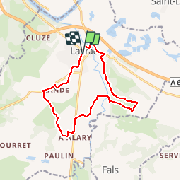
Trail Walking of 14.2 km to be discovered at New Aquitaine, Lot-et-Garonne, Layrac. This trail is proposed by tracegps.

Description

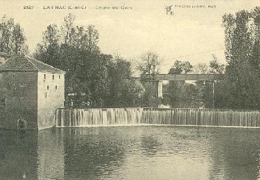
Layrac Communauté d’Agglomération d’Agen. Étagé sur le versant d’un coteau qui domine au Nord le confluent du Gers et de la Garonne, ce village s’est développé autour d’un prieuré clunisien datant du 11ème siècle. Téléchargez la fiche de cette randonnée sur le site du Tourisme du Lot et Garonne.

Elevation profile

Photos

Positioning

Country:
France
Region :
New Aquitaine
Department/Province :
Lot-et-Garonne
Municipality :
Layrac
Location:
Unknown
Start:(UTM)
312862 ; 4889339 (31T) N.

Comments

Please log in to post a review or rate the element


agréable


Trails nearby

Trail Walking Moirax - Du Prieuré de Moirax à l'église de Sainte-Marie d'Aubiac - Pays de l'Agenais - Photo
Walking
tracegps

Walking

Difficult
(1)
Moirax, New Aquitaine, Lot-et-Garonne, France
15.2 km | 22 km-effort
4h 10min
Yes
Trail Mountain bike Lafox - super rando du mercredi - Photo
Mountain bike
wardom

Mountain bike

Difficult
(1)
Lafox, New Aquitaine, Lot-et-Garonne, France
21 km | 26 km-effort
1h 29min
Yes
Trail Mountain bike Moirax - Moirax, dans les coteaux de Marescot - Photo
Mountain bike
tracegps

Mountain bike

Medium
Moirax, New Aquitaine, Lot-et-Garonne, France
13.2 km | 17.7 km-effort
1h 40min
Yes
Trail Walking Moirax - Moirax, dans les coteaux de Marescot - Photo
Walking
tracegps

Walking

Difficult
(1)
Moirax, New Aquitaine, Lot-et-Garonne, France
13.2 km | 17.7 km-effort
3h 25min
Yes
Trail Walking Boé - Passeligne pélissier - Photo
Walking
gege47

Walking

Very easy
Boé, New Aquitaine, Lot-et-Garonne, France
5 km | 5.5 km-effort
1h 10min
Yes
Trail Mountain bike Sauveterre-Saint-Denis - Sauveterre St Denis - Photo
Mountain bike
tracegps

Mountain bike

Medium
Sauveterre-Saint-Denis, New Aquitaine, Lot-et-Garonne, France
30 km | 34 km-effort
2h 0min
Yes
Trail Walking Sauveterre-Saint-Denis - Sauveterre St Denis - Photo
Walking
tracegps

Walking

Very difficult
Sauveterre-Saint-Denis, New Aquitaine, Lot-et-Garonne, France
30 km | 34 km-effort
6h 0min
Yes
Trail Equestrian Moirax - Du Prieuré de Moirax à l'église de Sainte-Marie d'Aubiac - Pays de l'Agenais - Photo
Equestrian
tracegps

Equestrian

Difficult
Moirax, New Aquitaine, Lot-et-Garonne, France
15.2 km | 22 km-effort
2h 40min
Yes
Trail Mountain bike Moirax - Du Prieuré de Moirax à l'église de Sainte-Marie d'Aubiac - Pays de l'Agenais - Photo
Mountain bike
tracegps

Mountain bike

Difficult
Moirax, New Aquitaine, Lot-et-Garonne, France
15.2 km | 22 km-effort
2h 0min
Yes


Close
My subscriptions