Trail Walking Le Mas-d'Agenais - Le Mas-d'Agenais, du canal à la forêt - Pays Val de Garonne - Gascogne - Photo

Le Mas-d'Agenais, du canal à la forêt - Pays Val de Garonne - Gascogne

 tracegps
tracegps

User

© OpenStreetMap contributors
Length
Length
12.7 km
Max alt
Max alt
93 m
Uphill gradient
Uphill gradient
149 m
Km-Effort
Km-Effort  
14.7 km
Min alt
Min alt
27 m
Downhill gradient
Downhill gradient
148 m
Boucle
Boucle
Yes
Creation date :
2014-12-10 00:00:00.0
Updated on :
2014-12-10 00:00:00.0

(1 Reviews)

Walking
Walking
3h15
Difficulty : Medium

Scan this QR Code to open this trail in the SityTrail application

FREE GPS app for hiking

Logo SityTrail SityTrail

IGN / Geographical institutes

Download SityTrail from the App Store Download SityTrail from Google Play

Logo SityTrail SityTrail World

The world is yours!

Download SityTrail from the App Store Download SityTrail from Google Play Download SityTrail on Huawei AppGallery

About

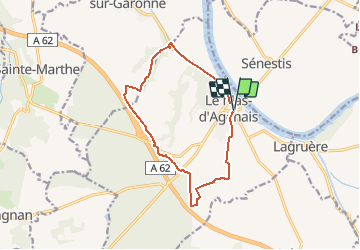
Trail Walking of 12.7 km to be discovered at New Aquitaine, Lot-et-Garonne, Le Mas-d'Agenais. This trail is proposed by tracegps.

Description

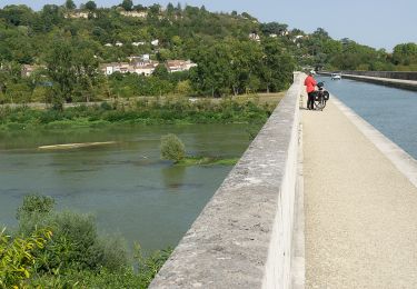
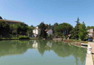
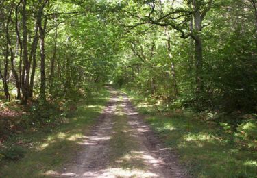
Le Mas d’Agenais / Canal de Garonne Cté Com. Val de Garonne. Cette randonnée au relief très peu prononcé, fait la liaison entre le village irrigué par la Garonne et le canal, et la forêt qui ne sera qu’effleurée. Une autre fiche vous fera découvrir le massif forestier. Téléchargez la fiche de cette randonnée sur le site du Tourisme du Lot et Garonne.

Elevation profile

Photos

Positioning

Country:
France
Region :
New Aquitaine
Department/Province :
Lot-et-Garonne
Municipality :
Le Mas-d'Agenais
Location:
Unknown
Start:(UTM)
278559 ; 4921121 (31T) N.

Comments

Please log in to post a review or rate the element


Trails nearby

Trail On foot Le Mas-d'Agenais - Le Mas-d'Agenais, du canal à la forêt - 12.8 km - Photo
On foot
PRO

On foot

Easy
Le Mas-d'Agenais, New Aquitaine, Lot-et-Garonne, France
12.7 km | 14.6 km-effort
3h 19min
Yes
Trail On foot Lagruère - Lagruère, dans la boucle de l'Ourbise - 10.6 km - Photo
On foot
PRO

On foot

Easy
Lagruère, New Aquitaine, Lot-et-Garonne, France
10.5 km | 11.6 km-effort
2h 37min
Yes
Trail On foot Calonges - Calonges, balade dans la plaine de la Garonne - 11.8 km - Photo
On foot
PRO

On foot

Easy
Calonges, New Aquitaine, Lot-et-Garonne, France
4.2 km | 4.6 km-effort
1h 3min
No
Trail Bicycle tourism Le Mas-d'Agenais - Mas d'Agenais-Agen - Photo
Bicycle tourism
ilur56

Bicycle tourism

Medium
Le Mas-d'Agenais, New Aquitaine, Lot-et-Garonne, France
52 km | 58 km-effort
Unknown
No
Trail On foot Le Mas-d'Agenais - Le Mas-d'Agenais - Les princes des sous-bois en forêt du Mas (Variante) - 5.4 km - Photo
On foot
PRO

On foot

Easy
Le Mas-d'Agenais, New Aquitaine, Lot-et-Garonne, France
5.4 km | 6 km-effort
1h 22min
Yes
Trail On foot Le Mas-d'Agenais - Le Mas-d'Agenais - Les princes des sous-bois en forêt du Mas - 7 km - Photo
On foot
PRO

On foot

Easy
Le Mas-d'Agenais, New Aquitaine, Lot-et-Garonne, France
7 km | 7.8 km-effort
1h 46min
Yes
Trail Cycle Le Mas-d'Agenais - Liaison Pays du Dropt - Voie Verte du Canal de Garonne - Photo
Cycle
tracegps

Cycle

Medium
Le Mas-d'Agenais, New Aquitaine, Lot-et-Garonne, France
59 km | 68 km-effort
3h 0min
No
Trail Mountain bike Le Mas-d'Agenais - Le Mas-d'Agenais, du canal à la forêt - Pays Val de Garonne - Gascogne - Photo
Mountain bike
tracegps

Mountain bike

Medium
Le Mas-d'Agenais, New Aquitaine, Lot-et-Garonne, France
12.7 km | 14.7 km-effort
1h 40min
Yes
Trail Mountain bike Le Mas-d'Agenais - Le Mas-d'Agenais, la Forêt - Pays Val de Garonne - Gascogne - Photo
Mountain bike
tracegps

Mountain bike

Medium
Le Mas-d'Agenais, New Aquitaine, Lot-et-Garonne, France
7 km | 7.9 km-effort
49min
Yes


Close
My subscriptions