Trail Walking Feugarolles - Limon, vignobles et vergers d'Albret - Pays d'Albret - Photo

Limon, vignobles et vergers d'Albret - Pays d'Albret

 tracegps
tracegps

User

© OpenStreetMap contributors
Length
Length
11.7 km
Max alt
Max alt
167 m
Uphill gradient
Uphill gradient
317 m
Km-Effort
Km-Effort  
15.9 km
Min alt
Min alt
43 m
Downhill gradient
Downhill gradient
318 m
Boucle
Boucle
Yes
Creation date :
2014-12-10 00:00:00.0
Updated on :
2014-12-10 00:00:00.0

(1 Reviews)

Walking
Walking
3h15
Difficulty : Medium

Scan this QR Code to open this trail in the SityTrail application

FREE GPS app for hiking

Logo SityTrail SityTrail

IGN / Geographical institutes

Download SityTrail from the App Store Download SityTrail from Google Play

Logo SityTrail SityTrail World

The world is yours!

Download SityTrail from the App Store Download SityTrail from Google Play Download SityTrail on Huawei AppGallery

About

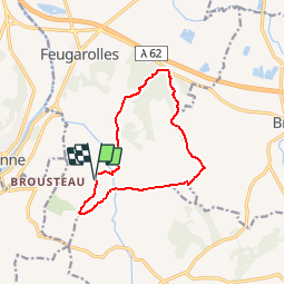
Trail Walking of 11.7 km to be discovered at New Aquitaine, Lot-et-Garonne, Feugarolles. This trail is proposed by tracegps.

Description

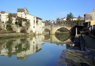
Limon Commune de Feugarolles Cté de Com. du Val d’Albret. Du seuil de la vallée de la Garonne, enfoncez-vous dans les coteaux, parfois escarpés, à l’important patrimoine bâti. Retrouvez les vignobles et vergers qui font du département le plus grand jardin de France. Téléchargez la fiche de cette randonnée sur le site du Tourisme du Lot et Garonne.

Elevation profile

Photos

Positioning

Country:
France
Region :
New Aquitaine
Department/Province :
Lot-et-Garonne
Municipality :
Feugarolles
Location:
Unknown
Start:(UTM)
288356 ; 4896757 (31T) N.

Comments

Please log in to post a review or rate the element


rando tres agréable au moment des vendanges


Trails nearby

Trail Walking Nérac - Gélise, frontière des sables - Pays d'Albret - Photo
Walking
tracegps

Walking

Medium
(1)
Nérac, New Aquitaine, Lot-et-Garonne, France
10.2 km | 12.7 km-effort
2h 30min
Yes
Trail On foot Buzet-sur-Baïse - Buzet, un port entre Canal et Baïse - 13.1 km - Photo
On foot
PRO

On foot

Easy
Buzet-sur-Baïse, New Aquitaine, Lot-et-Garonne, France
6.8 km | 7.6 km-effort
1h 43min
No
Trail On foot Vianne - Buzet, un pont-canal sur la Baïse - 8.5 km - Photo
On foot
PRO

On foot

Easy
Vianne, New Aquitaine, Lot-et-Garonne, France
5.9 km | 6.3 km-effort
1h 26min
No
Trail On foot Espiens - Espiens, dans les coteaux, vers le château de Salles - 10.7km - Photo
On foot
PRO

On foot

Easy
Espiens, New Aquitaine, Lot-et-Garonne, France
9 km | 11.8 km-effort
2h 40min
No
Trail On foot Bruch - Bruch, points de vue sur la vallée de la Garonne - 4.1 km - Photo
On foot
PRO

On foot

Easy
Bruch, New Aquitaine, Lot-et-Garonne, France
3 km | 4.6 km-effort
1h 3min
Yes
Trail Walking Bruch - Points de vue sur la vallée de la Garonne - Bruch - Photo
Walking
tracegps

Walking

Easy
Bruch, New Aquitaine, Lot-et-Garonne, France
4 km | 5.8 km-effort
1h 30min
Yes
Trail Walking Nérac - Nérac, du Moulin des Tours au château d'Henri IV - Barbaste - Photo
Walking
tracegps

Walking

Medium
Nérac, New Aquitaine, Lot-et-Garonne, France
7.7 km | 9.1 km-effort
2h 19min
No
Trail Other activity Bruch - bruch - Photo
Other activity
kilometre

Other activity

Easy
Bruch, New Aquitaine, Lot-et-Garonne, France
10.2 km | 13.5 km-effort
2h 25min
Yes
Trail On foot Espiens - Feugarolles, Brazalemn et Limon, vignobles et vergers d'Albret - 11.8 km - Photo
On foot
PRO

On foot

Easy
Espiens, New Aquitaine, Lot-et-Garonne, France
11.8 km | 16 km-effort
3h 37min
Yes


Close
My subscriptions