Trail Walking Hautefage-la-Tour - Bonneval, le circuit des trois églises - Pays de la vallée du Lot - Photo

Bonneval, le circuit des trois églises - Pays de la vallée du Lot

 tracegps
tracegps

User

© OpenStreetMap contributors
Length
Length
10 km
Max alt
Max alt
213 m
Uphill gradient
Uphill gradient
233 m
Km-Effort
Km-Effort  
13.1 km
Min alt
Min alt
115 m
Downhill gradient
Downhill gradient
244 m
Boucle
Boucle
Yes
Creation date :
2014-12-10 00:00:00.0
Updated on :
2014-12-10 00:00:00.0

(1 Reviews)

Walking
Walking
2h40
Difficulty : Medium

Scan this QR Code to open this trail in the SityTrail application

FREE GPS app for hiking

Logo SityTrail SityTrail

IGN / Geographical institutes

Download SityTrail from the App Store Download SityTrail from Google Play

Logo SityTrail SityTrail World

The world is yours!

Download SityTrail from the App Store Download SityTrail from Google Play Download SityTrail on Huawei AppGallery

About

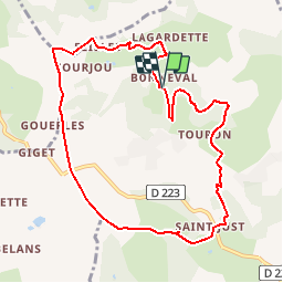
Trail Walking of 10 km to be discovered at New Aquitaine, Lot-et-Garonne, Hautefage-la-Tour. This trail is proposed by tracegps.

Description

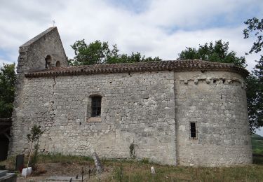
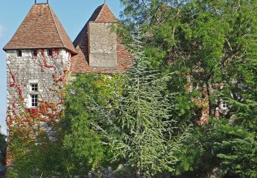
Bonneval Commune d’Hautefage la Tour C. C. du canton de Penne. L’église de Bonneval pour démarrer ; un peu plus loin, vue sur le clocher de Saint-Thomas et après le passage dans le hameau de Piquepoul, vous découvrirez celle de Saint-Just. Téléchargez la fiche de cette randonnée sur le site du Tourisme du Lot et Garonne.

Elevation profile

Photos

Positioning

Country:
France
Region :
New Aquitaine
Department/Province :
Lot-et-Garonne
Municipality :
Hautefage-la-Tour
Location:
Unknown
Start:(UTM)
321538 ; 4914082 (31T) N.

Comments

Please log in to post a review or rate the element


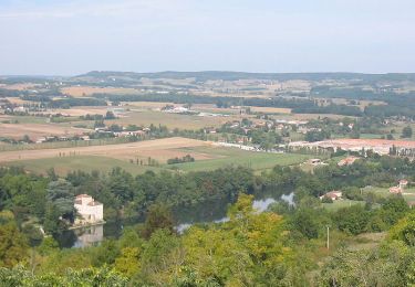
Très belle ballade dans les collines


Trails nearby

Trail Walking Pujols - Cambes, un circuit autour d'une combe boisée - Pays de la vallée du Lot - Photo
Walking
tracegps

Walking

Easy
(1)
Pujols, New Aquitaine, Lot-et-Garonne, France
4.2 km | 5.7 km-effort
1h 15min
Yes
Trail Walking Penne-d'Agenais - Penne-d'Agenais, vers le château de Noaillac - Pays de la vallée du Lot - Photo
Walking
tracegps

Walking

Difficult
(2)
Penne-d'Agenais, New Aquitaine, Lot-et-Garonne, France
13 km | 17.8 km-effort
3h 30min
Yes
Trail Mountain bike Penne-d'Agenais - Penne-d'Agenais, sur le plateau Saint-Michel - Pays de la vallée du Lot - Photo
Mountain bike
tracegps

Mountain bike

Difficult
(1)
Penne-d'Agenais, New Aquitaine, Lot-et-Garonne, France
10.5 km | 14.5 km-effort
1h 19min
Yes
Trail On foot Hautefage-la-Tour - Saint-Thomas, par Saint-Just et Piquepoul - 10.6 km - Photo
On foot
PRO

On foot

Easy
Hautefage-la-Tour, New Aquitaine, Lot-et-Garonne, France
10.2 km | 13.9 km-effort
3h 9min
Yes
Trail On foot Saint-Antoine-de-Ficalba - Bonneval, le circuit des trois églises - 10,7km - Photo
On foot
PRO

On foot

Easy
Saint-Antoine-de-Ficalba, New Aquitaine, Lot-et-Garonne, France
10.9 km | 14.2 km-effort
3h 14min
Yes
Trail On foot Hautefage-la-Tour - Hautefage - la tour, la balade de la Malausie - 4.9km - Photo
On foot
PRO

On foot

Easy
Hautefage-la-Tour, New Aquitaine, Lot-et-Garonne, France
3.8 km | 5.2 km-effort
1h 10min
No
Trail On foot Penne-d'Agenais - Penne-d’Agenais, vers le château de Noaillac - 13,2km - Photo
On foot
PRO

On foot

Easy
Penne-d'Agenais, New Aquitaine, Lot-et-Garonne, France
13.1 km | 17.8 km-effort
4h 2min
Yes
Trail On foot Penne-d'Agenais - Penne-d’Agenais, sur le plateau Saint-Michel -10,7km - Photo
On foot
PRO

On foot

Easy
Penne-d'Agenais, New Aquitaine, Lot-et-Garonne, France
10 km | 13.9 km-effort
3h 8min
Yes
Trail Walking Penne-d'Agenais - La randonnée de Penne d'agenais- Lot et Garonne  - Photo
Walking
alainjoseph6

Walking

Medium
Penne-d'Agenais, New Aquitaine, Lot-et-Garonne, France
7.2 km | 9.8 km-effort
2h 20min
Yes


Close
My subscriptions