Trail Walking Montayral - Montayral, au départ de l'observatoire de Lagrolère - Pays de la vallée du Lot - Photo

Montayral, au départ de l'observatoire de Lagrolère - Pays de la vallée du Lot

 tracegps
tracegps

User

© OpenStreetMap contributors
Length
Length
5.6 km
Max alt
Max alt
199 m
Uphill gradient
Uphill gradient
114 m
Km-Effort
Km-Effort  
7.2 km
Min alt
Min alt
120 m
Downhill gradient
Downhill gradient
113 m
Boucle
Boucle
Yes
Creation date :
2014-12-10 00:00:00.0
Updated on :
2014-12-10 00:00:00.0

(1 Reviews)

Walking
Walking
1h30
Difficulty : Easy

Scan this QR Code to open this trail in the SityTrail application

FREE GPS app for hiking

Logo SityTrail SityTrail

IGN / Geographical institutes

Download SityTrail from the App Store Download SityTrail from Google Play

Logo SityTrail SityTrail World

The world is yours!

Download SityTrail from the App Store Download SityTrail from Google Play Download SityTrail on Huawei AppGallery

About

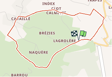
Trail Walking of 5.6 km to be discovered at New Aquitaine, Lot-et-Garonne, Montayral. This trail is proposed by tracegps.

Description

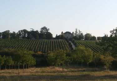
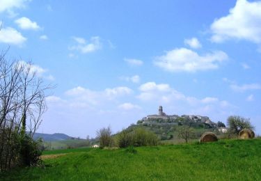
Montayral / Cavaillé Cté de Communes Fumélois Lémance. Trait d’union entre le Quercy et l’Agenais, le Lot change à Montayral. Tortueux dans les causses, il élargit ici ses méandres. Sur le circuit, le contraste est saisissant entre le plateau calcaire planté de sapins et les chênes de la plaine. Téléchargez la fiche de cette randonnée sur le site du Tourisme du Lot et Garonne.

Elevation profile

Photos

Positioning

Country:
France
Region :
New Aquitaine
Department/Province :
Lot-et-Garonne
Municipality :
Montayral
Location:
Unknown
Start:(UTM)
340967 ; 4925335 (31T) N.

Comments

Please log in to post a review or rate the element


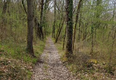
tres symphatique rando, a faire de preference quand il fait beau, pour les points de vue.


Trails nearby

Trail Equestrian Fumel - Le GR de pays du château de Fumel au château de Bonaguil - Photo
Equestrian
tracegps

Equestrian

Easy
Fumel, New Aquitaine, Lot-et-Garonne, France
9.4 km | 12.1 km-effort
1h 40min
No
Trail Mountain bike Fumel - Le GR de pays du château de Fumel au château de Bonaguil - Photo
Mountain bike
tracegps

Mountain bike

Easy
(1)
Fumel, New Aquitaine, Lot-et-Garonne, France
9.4 km | 12.1 km-effort
1h 15min
No
Trail Walking Fumel - Le GR de pays du château de Fumel au château de Bonaguil - Photo
Walking
tracegps

Walking

Medium
Fumel, New Aquitaine, Lot-et-Garonne, France
9.4 km | 12.1 km-effort
2h 30min
No
Trail Motor Fumel - Fumel circuit voiture - Photo
Motor
jmc47500

Motor

Easy
(1)
Fumel, New Aquitaine, Lot-et-Garonne, France
84 km | 104 km-effort
7h 0min
Yes
Trail Bicycle tourism Mauroux - Mauroux, Puy l'évêque - Photo
Bicycle tourism
delestrai

Bicycle tourism

Easy
Mauroux, Occitania, Lot, France
24 km | 28 km-effort
1h 40min
Yes
Trail Bicycle tourism Mauroux - Mauroux - Photo
Bicycle tourism
delestrai

Bicycle tourism

Easy
Mauroux, Occitania, Lot, France
28 km | 33 km-effort
1h 40min
Yes
Trail Walking Thézac - thezac - Photo
Walking
Laurent Pistore

Walking

Very easy
(1)
Thézac, New Aquitaine, Lot-et-Garonne, France
11.6 km | 15.2 km-effort
2h 38min
Yes
Trail Mountain bike Thézac - VTT autour de Thézac - Photo
Mountain bike
tracegps

Mountain bike

Difficult
Thézac, New Aquitaine, Lot-et-Garonne, France
30 km | 37 km-effort
2h 30min
Yes
Trail Mountain bike Thézac - Thézac, balade dans les coteaux du Quercy - Pays de la vallée du Lot - Photo
Mountain bike
tracegps

Mountain bike

Easy
Thézac, New Aquitaine, Lot-et-Garonne, France
5.2 km | 6.9 km-effort
40min
Yes


Close
My subscriptions