Trail Cross-country skiing Xonrupt-Longemer - Gerardmer (Le Poli) 3 200m +63m - Photo

Gerardmer (Le Poli) 3 200m +63m

© OpenStreetMap contributors
Length
Length
3.1 km
Max alt
Max alt
1064 m
Uphill gradient
Uphill gradient
63 m
Km-Effort
Km-Effort  
3.9 km
Min alt
Min alt
1004 m
Downhill gradient
Downhill gradient
64 m
Boucle
Boucle
Yes
Creation date :
2019-05-06 14:44:27.497
Updated on :
2021-01-13 20:01:03.547

(0 Reviews)

Cross-country skiing
--
Difficulty : Very easy

Scan this QR Code to open this trail in the SityTrail application

FREE GPS app for hiking

Logo SityTrail SityTrail

IGN / Geographical institutes

Download SityTrail from the App Store Download SityTrail from Google Play

Logo SityTrail SityTrail World

The world is yours!

Download SityTrail from the App Store Download SityTrail from Google Play Download SityTrail on Huawei AppGallery

About

Trail Cross-country skiing of 3.1 km to be discovered at Grand Est, Vosges, Xonrupt-Longemer. This trail is proposed by DanielROLLET.

Description

2019 02 14 12:00 à 13:30
Sortie ski de fond avec Marie
Super temps

Elevation profile

Positioning

Country:
France
Region :
Grand Est
Department/Province :
Vosges
Municipality :
Xonrupt-Longemer
Location:
Unknown
Start:(UTM)
344530 ; 5325468 (32U) N.

Trails nearby

Trail Walking La Bresse - 2023-04-15 Marche Abri Collet de Etang vers Abri Lac de Blanchemer - Photo
Walking
GUIDE
holtzv

Walking

Medium
(1)
La Bresse, Grand Est, Vosges, France
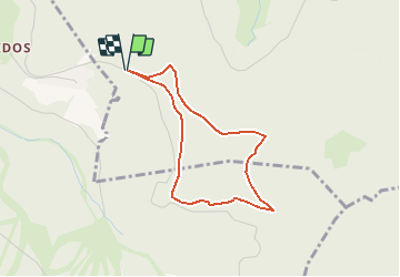
22 km | 35 km-effort
7h 51min
No
Trail Walking La Bresse - Lac de Lispach et sentier Dielaine  - Photo
Walking
zazie

Walking

Medium
(1)
La Bresse, Grand Est, Vosges, France
9.7 km | 14.9 km-effort
2h 30min
Yes
Trail Nordic walking Gérardmer - ramonchamp. observatoire de merelle, saut de la bourrique  - Photo
Nordic walking
francislassauce

Nordic walking

Difficult
(1)
Gérardmer, Grand Est, Vosges, France
11.1 km | 15.8 km-effort
3h 30min
Yes
Trail Walking La Bresse - Les 5 lacs autour du Hohneck - Photo
Walking
tiene

Walking

Very difficult
(1)
La Bresse, Grand Est, Vosges, France
21 km | 36 km-effort
7h 21min
Yes
Trail Walking La Bresse - lac de Lispach - Photo
Walking
fedinois1

Walking

Easy
(1)
La Bresse, Grand Est, Vosges, France
10.4 km | 14.1 km-effort
4h 6min
Yes
Trail Walking La Bresse - lac de Lispach - Photo
Walking
fedinois1

Walking

Easy
(3)
La Bresse, Grand Est, Vosges, France
10.4 km | 14.1 km-effort
4h 6min
Yes
Trail Mountain bike La Bresse - randonnée découverte à la Bresse.  - Photo
Mountain bike
Dutyrider

Mountain bike

Easy
(1)
La Bresse, Grand Est, Vosges, France
30 km | 41 km-effort
2h 58min
Yes
Trail Walking Ban-sur-Meurthe-Clefcy - La vallée de Belbriette - Ban-sur-Meurthe-Clefcy - Photo
Walking
tracegps

Walking

Medium
(2)
Ban-sur-Meurthe-Clefcy, Grand Est, Vosges, France
9.8 km | 12.6 km-effort
2h 30min
Yes
Trail Walking Gérardmer - La Tête de Mérelle - Photo
Walking
tracegps

Walking

Medium
(4)
Gérardmer, Grand Est, Vosges, France
4.7 km | 9 km-effort
2h 30min
Yes


Close
My subscriptions