Trail Walking Saint-Front-sur-Lémance - Bonaguil, du château à l'église de Lastreilles - Pays de la vallée du Lot - Photo

Bonaguil, du château à l'église de Lastreilles - Pays de la vallée du Lot

 tracegps
tracegps

User

© OpenStreetMap contributors
Length
Length
14.9 km
Max alt
Max alt
250 m
Uphill gradient
Uphill gradient
357 m
Km-Effort
Km-Effort  
19.7 km
Min alt
Min alt
117 m
Downhill gradient
Downhill gradient
356 m
Boucle
Boucle
Yes
Creation date :
2014-12-10 00:00:00.0
Updated on :
2014-12-10 00:00:00.0

(2 Reviews)

Walking
Walking
4h00
Difficulty : Difficult

Scan this QR Code to open this trail in the SityTrail application

FREE GPS app for hiking

Logo SityTrail SityTrail

IGN / Geographical institutes

Download SityTrail from the App Store Download SityTrail from Google Play

Logo SityTrail SityTrail World

The world is yours!

Download SityTrail from the App Store Download SityTrail from Google Play Download SityTrail on Huawei AppGallery

About

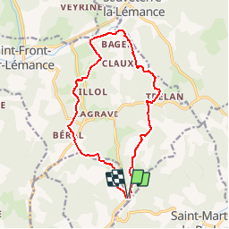
Trail Walking of 14.9 km to be discovered at New Aquitaine, Lot-et-Garonne, Saint-Front-sur-Lémance. This trail is proposed by tracegps.

Description

Bonaguil / Lastreilles Cté de Communes Fumélois Lémance. Du château de Bonaguil à l’église de Lastreilles, cette randonnée forestière, assez physique, se déroule à travers chênaies, châtaigneraies, charmilles, mais aussi dans quelques pinèdes. Téléchargez la fiche de cette randonnée sur le site du Tourisme du Lot et Garonne.

Elevation profile

Photos

Positioning

Country:
France
Region :
New Aquitaine
Department/Province :
Lot-et-Garonne
Municipality :
Saint-Front-sur-Lémance
Location:
Unknown
Start:(UTM)
342127 ; 4933475 (31T) N.

Comments

Please log in to post a review or rate the element


Trails nearby

Trail Walking Saint-Front-sur-Lémance - La randonnée de Bonaguil -Balisage jaune  - Photo
Walking
alainjoseph6

Walking

Medium
Saint-Front-sur-Lémance, New Aquitaine, Lot-et-Garonne, France
8.1 km | 10.4 km-effort
2h 49min
Yes
Trail Walking Saint-Front-sur-Lémance - boucle bonaguil via lastreilles - Photo
Walking
fab0202

Walking

Easy
Saint-Front-sur-Lémance, New Aquitaine, Lot-et-Garonne, France
16.1 km | 21 km-effort
4h 9min
Yes
Trail Equestrian Fumel - Le GR de pays du château de Fumel au château de Bonaguil - Photo
Equestrian
tracegps

Equestrian

Easy
Fumel, New Aquitaine, Lot-et-Garonne, France
9.4 km | 12.1 km-effort
1h 40min
No
Trail Mountain bike Fumel - Le GR de pays du château de Fumel au château de Bonaguil - Photo
Mountain bike
tracegps

Mountain bike

Easy
(1)
Fumel, New Aquitaine, Lot-et-Garonne, France
9.4 km | 12.1 km-effort
1h 15min
No
Trail Walking Fumel - Le GR de pays du château de Fumel au château de Bonaguil - Photo
Walking
tracegps

Walking

Medium
Fumel, New Aquitaine, Lot-et-Garonne, France
9.4 km | 12.1 km-effort
2h 30min
No
Trail Mountain bike Saint-Front-sur-Lémance - Bonaguil, sur le GR® 36, entre Périgord et Quercy - Photo
Mountain bike
tracegps

Mountain bike

Medium
Saint-Front-sur-Lémance, New Aquitaine, Lot-et-Garonne, France
9.3 km | 12.3 km-effort
1h 10min
Yes
Trail Walking Saint-Front-sur-Lémance - Bonaguil, sur le GR® 36, entre Périgord et Quercy - Photo
Walking
tracegps

Walking

Medium
Saint-Front-sur-Lémance, New Aquitaine, Lot-et-Garonne, France
9.3 km | 12.3 km-effort
3h 0min
Yes
Trail Motor Fumel - Fumel circuit voiture - Photo
Motor
jmc47500

Motor

Easy
(1)
Fumel, New Aquitaine, Lot-et-Garonne, France
84 km | 104 km-effort
7h 0min
Yes
Trail Walking Cuzorn - tuc blanc - Photo
Walking
adgjm

Walking

Very easy
(1)
Cuzorn, New Aquitaine, Lot-et-Garonne, France
7.6 km | 9.3 km-effort
2h 44min
No


Close
My subscriptions