Trail Walking Oloron-Sainte-Marie - Sentier karstique - Piémont Oloronais - Photo

Sentier karstique - Piémont Oloronais

 tracegps
tracegps

User

© OpenStreetMap contributors
Length
Length
2.7 km
Max alt
Max alt
316 m
Uphill gradient
Uphill gradient
75 m
Km-Effort
Km-Effort  
3.7 km
Min alt
Min alt
253 m
Downhill gradient
Downhill gradient
80 m
Boucle
Boucle
Yes
Creation date :
2014-12-10 00:00:00.0
Updated on :
2014-12-10 00:00:00.0

(1 Reviews)

Walking
Walking
1h00
Difficulty : Easy

Scan this QR Code to open this trail in the SityTrail application

FREE GPS app for hiking

Logo SityTrail SityTrail

IGN / Geographical institutes

Download SityTrail from the App Store Download SityTrail from Google Play

Logo SityTrail SityTrail World

The world is yours!

Download SityTrail from the App Store Download SityTrail from Google Play Download SityTrail on Huawei AppGallery

About

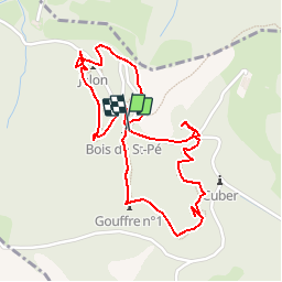
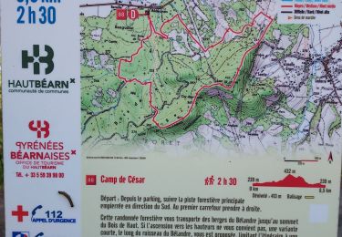
Trail Walking of 2.7 km to be discovered at New Aquitaine, Pyrénées-Atlantiques, Oloron-Sainte-Marie. This trail is proposed by tracegps.

Description

Unique en son genre et spectaculaire, cet itinéraire qui va de gouffre en gouffre est une porte ouverte sur le monde souterrain. Sur un sentier forestier et par des passerelles au-dessus des grottes, vous découvrirez, le temps d´une balade familiale,l´immense et insoupçonnable réseau de cavités ouvertes sous nos pieds. Retrouvez d’autres informations et la fiche descriptive sur le site Pays Basque et Béarn.

Elevation profile

Photos

Positioning

Country:
France
Region :
New Aquitaine
Department/Province :
Pyrénées-Atlantiques
Municipality :
Oloron-Sainte-Marie
Location:
Unknown
Start:(UTM)
688946 ; 4783618 (30T) N.

Comments

Please log in to post a review or rate the element


Trails nearby

Trail Walking Ance-Féas - Ance Unars G3 2021 - Photo
Walking
LouisROGER

Walking

Very difficult
Ance-Féas, New Aquitaine, Pyrénées-Atlantiques, France
13.3 km | 20 km-effort
3h 50min
Yes
Trail Walking Oloron-Sainte-Marie - Chemin du Piémont Pyrénéen - De Oloron Sainte Marie à L'Hopital St Blaise - Photo
Walking
tracegps

Walking

Difficult
Oloron-Sainte-Marie, New Aquitaine, Pyrénées-Atlantiques, France
22 km | 27 km-effort
5h 45min
No
Trail Walking Oloron-Sainte-Marie - G4 Haut doloron - Photo
Walking
LouisROGER

Walking

Difficult
Oloron-Sainte-Marie, New Aquitaine, Pyrénées-Atlantiques, France
8.6 km | 12.3 km-effort
5h 14min
Yes
Trail Walking Oloron-Sainte-Marie - test OLORON versée dans TIAGO - Photo
Walking

Walking

Very difficult
Oloron-Sainte-Marie, New Aquitaine, Pyrénées-Atlantiques, France
22 km | 26 km-effort
5h 39min
No
Trail Walking Oloron-Sainte-Marie - Pyrenees-Atl - Oloron-Ste-Marie St-Pee-d-en-Bas Col de Sabareil 19km 451m - Photo
Walking
RandoVal

Walking

Very easy
Oloron-Sainte-Marie, New Aquitaine, Pyrénées-Atlantiques, France
19.2 km | 27 km-effort
Unknown
Yes
Trail Walking Esquiule - G3-ESQUIULE-Sommet de Cambilhou TC - Photo
Walking
mitch1952

Walking

Difficult
Esquiule, New Aquitaine, Pyrénées-Atlantiques, France
11.2 km | 18.7 km-effort
4h 14min
Yes
Trail On foot Esquiule - SityTrail - Sommet de Cambillou - Photo
On foot
mitch1952

On foot

Medium
Esquiule, New Aquitaine, Pyrénées-Atlantiques, France
11.3 km | 17.6 km-effort
4h 30min
Yes
Trail Walking Ance-Féas - Ance le jardin des fées-fait - Photo
Walking

Walking

Easy
(1)
Ance-Féas, New Aquitaine, Pyrénées-Atlantiques, France
11.9 km | 18.4 km-effort
3h 56min
Yes
Trail Walking Oloron-Sainte-Marie - olive - Photo
Walking
titouso

Walking

Very easy
Oloron-Sainte-Marie, New Aquitaine, Pyrénées-Atlantiques, France
5.5 km | 6.5 km-effort
1h 12min
Yes


Close
My subscriptions