Trail Walking Cubjac-Auvézère-Val d'Ans - Le chemin du Causse - Cubjac - Photo
 tracegps
tracegps

User

© OpenStreetMap contributors
Length
Length
7.9 km
Max alt
Max alt
206 m
Uphill gradient
Uphill gradient
161 m
Km-Effort
Km-Effort  
10 km
Min alt
Min alt
115 m
Downhill gradient
Downhill gradient
162 m
Boucle
Boucle
Yes
Creation date :
2014-12-10 00:00:00.0
Updated on :
2014-12-10 00:00:00.0

(0 Reviews)

Walking
Walking
2h00
Difficulty : Medium

Scan this QR Code to open this trail in the SityTrail application

FREE GPS app for hiking

Logo SityTrail SityTrail

IGN / Geographical institutes

Download SityTrail from the App Store Download SityTrail from Google Play

Logo SityTrail SityTrail World

The world is yours!

Download SityTrail from the App Store Download SityTrail from Google Play Download SityTrail on Huawei AppGallery

About

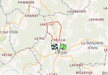
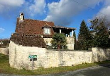
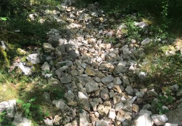
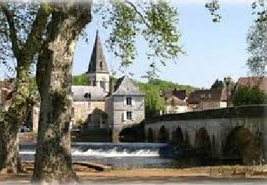
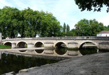
Trail Walking of 7.9 km to be discovered at New Aquitaine, Dordogne, Cubjac-Auvézère-Val d'Ans. This trail is proposed by tracegps.

Description

Circuit proposé par l’office du tourisme du Haut-Périgord. Départ de l’église de Cubjac Retrouvez sur le site de l’office du Haut-Périgord le desciptif et le plan. Ce circuit a été numérisé par les randonneurs du CODEPEM. Merci à Jean-Marie.

Elevation profile

Photos

Positioning

Country:
France
Region :
New Aquitaine
Department/Province :
Dordogne
Municipality :
Cubjac-Auvézère-Val d'Ans
Location:
Unknown
Start:(UTM)
338087 ; 5009669 (31T) N.

Trails nearby

Trail Walking Bassillac et Auberoche - Le Change Roc 9km - Photo
Walking
YV24

Walking

Very easy
(1)
Bassillac et Auberoche, New Aquitaine, Dordogne, France
9.3 km | 12.2 km-effort
2h 43min
Yes
Trail Walking Bassillac et Auberoche - Le Change Pommiers 9km - Photo
Walking
YV24

Walking

Easy
(1)
Bassillac et Auberoche, New Aquitaine, Dordogne, France
9 km | 11.3 km-effort
2h 32min
Yes
Trail On foot Bassillac et Auberoche - Les chabannes - Photo
On foot
Claire Maya

On foot

Easy
Bassillac et Auberoche, New Aquitaine, Dordogne, France
6.3 km | 8.2 km-effort
1h 52min
Yes
Trail Walking Cubjac-Auvézère-Val d'Ans - track - Photo
Walking
houbart

Walking

Very difficult
Cubjac-Auvézère-Val d'Ans, New Aquitaine, Dordogne, France
15.4 km | 19.7 km-effort
4h 28min
Yes
Trail Nordic walking Saint-Vincent-sur-l'Isle - Saint Vincent sur l'Isle MN - Photo
Nordic walking
CC.RIDER

Nordic walking

Medium
Saint-Vincent-sur-l'Isle, New Aquitaine, Dordogne, France
10.3 km | 12.6 km-effort
Unknown
Yes
Trail Nordic walking Saint-Vincent-sur-l'Isle - Saint Vincent sur l'Isle MN - Photo
Nordic walking
CC.RIDER

Nordic walking

Medium
Saint-Vincent-sur-l'Isle, New Aquitaine, Dordogne, France
10.3 km | 12.6 km-effort
Unknown
Yes
Trail Walking Montagnac-d'Auberoche - Boucle de la fontaine Marceau ( Montagnac d’ Auberoche)  - Photo
Walking
Marc 24

Walking

Easy
Montagnac-d'Auberoche, New Aquitaine, Dordogne, France
6.9 km | 8.6 km-effort
2h 9min
Yes
Trail Walking Cubjac-Auvézère-Val d'Ans - Boucle des Quatre Paroisses - Photo
Walking
CC.RIDER

Walking

Difficult
Cubjac-Auvézère-Val d'Ans, New Aquitaine, Dordogne, France
12.3 km | 15.9 km-effort
3h 36min
Yes
Trail Walking Cubjac-Auvézère-Val d'Ans - Les 4 paroisses - Cubjac - Photo
Walking
tracegps

Walking

Medium
(1)
Cubjac-Auvézère-Val d'Ans, New Aquitaine, Dordogne, France
12.5 km | 16.5 km-effort
3h 0min
Yes


Close
My subscriptions