Trail Walking Bruyères-le-Châtel - Bruyères Le Chatel, Courson, Saint Maurice - Photo

Bruyères Le Chatel, Courson, Saint Maurice

 Surot
Surot

User

© OpenStreetMap contributors
Length
Length
22 km
Max alt
Max alt
125 m
Uphill gradient
Uphill gradient
296 m
Km-Effort
Km-Effort  
26 km
Min alt
Min alt
57 m
Downhill gradient
Downhill gradient
296 m
Boucle
Boucle
Yes
Creation date :
2019-05-06 15:38:30.509
Updated on :
2019-05-06 15:38:30.509

(0 Reviews)

Walking
Walking
5h40
Difficulty : Medium

Scan this QR Code to open this trail in the SityTrail application

FREE GPS app for hiking

Logo SityTrail SityTrail

IGN / Geographical institutes

Download SityTrail from the App Store Download SityTrail from Google Play

Logo SityTrail SityTrail World

The world is yours!

Download SityTrail from the App Store Download SityTrail from Google Play Download SityTrail on Huawei AppGallery

About

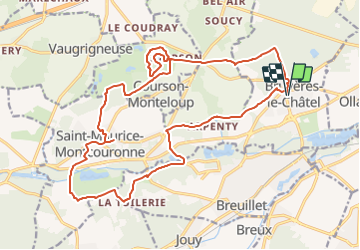
Trail Walking of 22 km to be discovered at Ile-de-France, Essonne, Bruyères-le-Châtel. This trail is proposed by Surot.

Description

22 km entre champs, bois, châteaux, lavoirs et bords de la Remarde, sans difficultés importantes

Elevation profile

Positioning

Country:
France
Region :
Ile-de-France
Department/Province :
Essonne
Municipality :
Bruyères-le-Châtel
Location:
Unknown
Start:(UTM)
440185 ; 5382418 (31U) N.

Trails nearby

Trail Walking Marcoussis - Autour de Leuville sur Orge - Photo
Walking
tracegps

Walking

Medium
(1)
Marcoussis, Ile-de-France, Essonne, France
27 km | 32 km-effort
5h 30min
Yes
Trail On foot Saint-Yon - Sur les traces de la Renarde - Photo
On foot
PRO

On foot

Very difficult
Saint-Yon, Ile-de-France, Essonne, France
38 km | 44 km-effort
10h 4min
No
Trail Mountain bike Fontenay-lès-Briis - Soucy / Le Marais - Photo
Mountain bike
Bora431

Mountain bike

Medium
(2)
Fontenay-lès-Briis, Ile-de-France, Essonne, France
25 km | 30 km-effort
1h 52min
Yes
Trail Walking Boissy-sous-Saint-Yon - Carrière de Madagascar  - Photo
Walking
danbott

Walking

Very easy
(1)
Boissy-sous-Saint-Yon, Ile-de-France, Essonne, France
13.2 km | 16.5 km-effort
2h 59min
Yes
Trail Walking Saint-Chéron - De Saint Chéron à Dourdan par les côteaux de la rive gauche - Photo
Walking
philippebenne

Walking

Difficult
(1)
Saint-Chéron, Ile-de-France, Essonne, France
13.5 km | 17 km-effort
3h 51min
No
Trail Walking Bruyères-le-Châtel - Boucle Fontenay les Briis - Photo
Walking
chessyca

Walking

Very easy
Bruyères-le-Châtel, Ile-de-France, Essonne, France
22 km | 26 km-effort
5h 4min
Yes
Trail Walking Saint-Maurice-Montcouronne - Boucle St Maurice Montcouronne - Brigitte - Photo
Walking
chessyca

Walking

Very easy
Saint-Maurice-Montcouronne, Ile-de-France, Essonne, France
21 km | 24 km-effort
4h 19min
Yes
Trail Walking Fontenay-lès-Briis - Essonne_Fontenay-Les-Briis=>Roche-Turpin=>Soucy(bis) - Photo
Walking
BMorin91470

Walking

Easy
Fontenay-lès-Briis, Ile-de-France, Essonne, France
8.6 km | 10.2 km-effort
2h 8min
Yes
Trail On foot Saint-Yon - FR-1 - Photo
On foot
PRO

On foot

Easy
Saint-Yon, Ile-de-France, Essonne, France
7.7 km | 8.4 km-effort
1h 54min
No


Close
My subscriptions