Trail Walking Felletin - Vallées et châteaux - Felletin / St Frion - Photo

Vallées et châteaux - Felletin / St Frion

 tracegps
tracegps

User

© OpenStreetMap contributors
Length
Length
19.8 km
Max alt
Max alt
701 m
Uphill gradient
Uphill gradient
528 m
Km-Effort
Km-Effort  
27 km
Min alt
Min alt
517 m
Downhill gradient
Downhill gradient
525 m
Boucle
Boucle
Yes
Creation date :
2014-12-10 00:00:00.0
Updated on :
2014-12-10 00:00:00.0

(1 Reviews)

Walking
Walking
5h00
Difficulty : Very difficult

Scan this QR Code to open this trail in the SityTrail application

FREE GPS app for hiking

Logo SityTrail SityTrail

IGN / Geographical institutes

Download SityTrail from the App Store Download SityTrail from Google Play

Logo SityTrail SityTrail World

The world is yours!

Download SityTrail from the App Store Download SityTrail from Google Play Download SityTrail on Huawei AppGallery

About

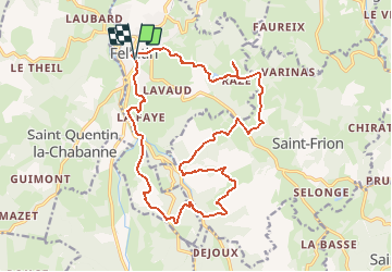
Trail Walking of 19.8 km to be discovered at New Aquitaine, Creuse, Felletin. This trail is proposed by tracegps.

Description

La Communauté de Communes Aubusson-Felletin vous propose ce circuit de 20 km, qui longe plusieurs rivières et ruisseaux (Creuse, Chavanat, Sannebèche, Bas-Bouteix, Arfeuille) et relie 2 châteaux, celui du Bas-Bouteix et celui d’Arfeuille. Un beau parcours en sous-bois et à travers les petits villages de Felletin, Saint Quentin-la-Chabanne et Saint-Frion. Départ de l’office de tourisme de Felletin, parking rue Reby Lagrange. Retrouvez ce circuit sur le site de la Communauté de Communes Aubusson-Felletin. D’autres circuits sont disponibles dans les offices de tourisme d’Aubusson et de Felletin.

Elevation profile

Photos

Positioning

Country:
France
Region :
New Aquitaine
Department/Province :
Creuse
Municipality :
Felletin
Location:
Unknown
Start:(UTM)
435919 ; 5081373 (31T) N.

Comments

Please log in to post a review or rate the element


ce circuit a été modifié à certains endroits du parcours. Il faut suivre le balisage jaune (PR) et de se repérer avec ce tracé. Le kilométrage doit être 21km environ . bonne randonnée. Audier.


Trails nearby

Trail Walking Saint-Quentin-la-Chabanne - Sur la trace des canards - Saint-Quentin-la-Chabanne - Photo
Walking
tracegps

Walking

Difficult
Saint-Quentin-la-Chabanne, New Aquitaine, Creuse, France
13.3 km | 17.7 km-effort
3h 30min
Yes
Trail Walking Saint-Marc-à-Frongier - Montrujas - Photo
Walking
DanieleBocourt

Walking

Easy
Saint-Marc-à-Frongier, New Aquitaine, Creuse, France
3.3 km | 4.2 km-effort
51min
Yes
Trail Other activity Moutier-Rozeille - m - Photo
Other activity
mflamy

Other activity

Very easy
Moutier-Rozeille, New Aquitaine, Creuse, France
9.1 km | 11.5 km-effort
2h 1min
Yes
Trail Walking Felletin - felletin-1 - Photo
Walking
fanthou

Walking

Medium
Felletin, New Aquitaine, Creuse, France
10.6 km | 14 km-effort
2h 59min
Yes
Trail Walking Moutier-Rozeille - moutier-rozeille-2 - Photo
Walking
fanthou

Walking

Medium
Moutier-Rozeille, New Aquitaine, Creuse, France
7.8 km | 10.2 km-effort
2h 12min
Yes
Trail Walking Moutier-Rozeille - moutier-rozeille-1 - Photo
Walking
fanthou

Walking

Medium
Moutier-Rozeille, New Aquitaine, Creuse, France
6.8 km | 9.4 km-effort
2h 0min
Yes


Close
My subscriptions