Trail Snowshoes Bussang - Circuit de raquette de Bussang - Photo

Circuit de raquette de Bussang

 tracegps
tracegps

User

© OpenStreetMap contributors
Length
Length
7.7 km
Max alt
Max alt
1052 m
Uphill gradient
Uphill gradient
257 m
Km-Effort
Km-Effort  
11.2 km
Min alt
Min alt
818 m
Downhill gradient
Downhill gradient
256 m
Boucle
Boucle
Yes
Creation date :
2014-12-10 00:00:00.0
Updated on :
2014-12-10 00:00:00.0

(1 Reviews)

Snowshoes
Snowshoes
3h00
Difficulty : Difficult

Scan this QR Code to open this trail in the SityTrail application

FREE GPS app for hiking

Logo SityTrail SityTrail

IGN / Geographical institutes

Download SityTrail from the App Store Download SityTrail from Google Play

Logo SityTrail SityTrail World

The world is yours!

Download SityTrail from the App Store Download SityTrail from Google Play Download SityTrail on Huawei AppGallery

About

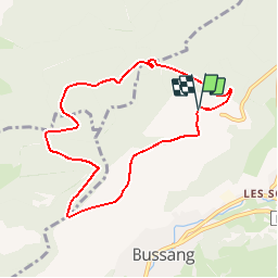
Trail Snowshoes of 7.7 km to be discovered at Grand Est, Vosges, Bussang. This trail is proposed by tracegps.

Description

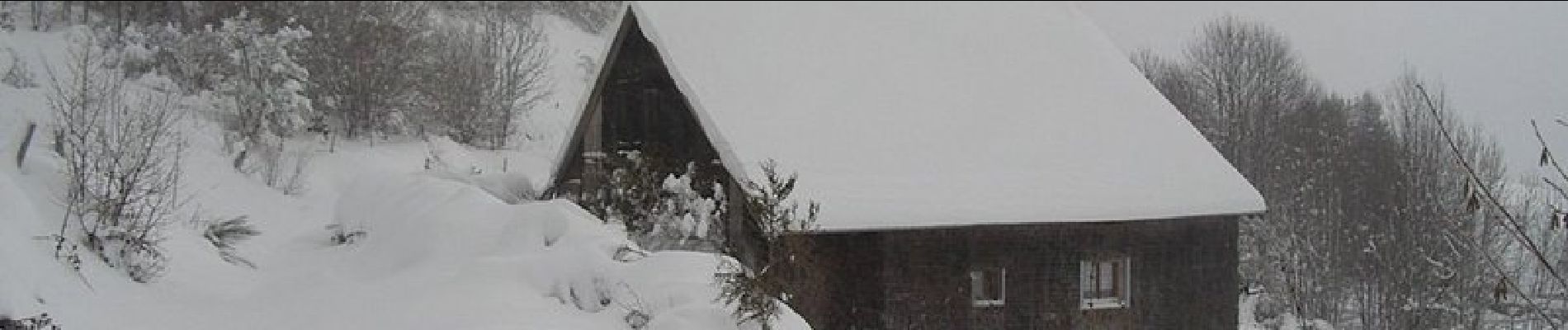
Circuit proposé l’office du tourisme de Bussang. Départ de la piste de ski de Larcenaire. La difficulté du circuit dépend de la quantité de neige (0,70 à 1 m de neige cette année)

Elevation profile

Photos

Positioning

Country:
France
Region :
Grand Est
Department/Province :
Vosges
Municipality :
Bussang
Location:
Unknown
Start:(UTM)
340148 ; 5307513 (32T) N.

Comments

Please log in to post a review or rate the element


Tred bonne appli


Trails nearby

Trail Walking Bussang - Col de Bussang - Rouge Gazon - Séchenat - Photo
Walking
VacheKiri67

Walking

Difficult
(1)
Bussang, Grand Est, Vosges, France
15 km | 24 km-effort
6h 0min
No
Trail Walking Ventron - L'Ermitage du Frère Joseph depuis Ventron - Photo
Walking
jeanclaude12

Walking

Easy
(1)
Ventron, Grand Est, Vosges, France
10.2 km | 15.4 km-effort
2h 49min
Yes
Trail Walking Fellering - Felsach _chapelle ST Nicolas_frenz - Photo
Walking
Le grand Claude

Walking

Difficult
(1)
Fellering, Grand Est, Haut-Rhin, France
9.6 km | 16.5 km-effort
3h 45min
Yes
Trail Mountain bike Bussang - activity_9407679223 - Photo
Mountain bike
GUIDE
pascalou73

Mountain bike

Medium
Bussang, Grand Est, Vosges, France
21 km | 30 km-effort
2h 2min
Yes
Trail Walking Ventron - 2022-02-19 Marche Ventron Tête des Champs - Photo
Walking
GUIDE
holtzv

Walking

Very difficult
Ventron, Grand Est, Vosges, France
22 km | 34 km-effort
5h 52min
Yes
Trail On foot Ventron - Circuit de la Croix de l’Hermite par Forgoutte - Photo
On foot
PRO

On foot

Easy
Ventron, Grand Est, Vosges, France
4.3 km | 6.6 km-effort
1h 29min
No
Trail On foot Ventron - Circuit panoramique de la Futaie - Photo
On foot
PRO

On foot

Easy
Ventron, Grand Est, Vosges, France
8.8 km | 12.6 km-effort
2h 52min
Yes
Trail Mountain bike Bussang - Bussang_20210918_101006 - Photo
Mountain bike
GUIDE
pascalou73

Mountain bike

Very easy
Bussang, Grand Est, Vosges, France
30 km | 43 km-effort
Unknown
No
Trail Mountain bike Bussang - Bussang_20210821_100939 (1) - Photo
Mountain bike
GUIDE
pascalou73

Mountain bike

Very easy
Bussang, Grand Est, Vosges, France
31 km | 42 km-effort
Unknown
No


Close
My subscriptions