Trail Walking Fellering - Felsach _chapelle ST Nicolas_frenz - Photo

Felsach _chapelle ST Nicolas_frenz

© OpenStreetMap contributors
Length
Length
9.6 km
Max alt
Max alt
1084 m
Uphill gradient
Uphill gradient
514 m
Km-Effort
Km-Effort  
16.5 km
Min alt
Min alt
575 m
Downhill gradient
Downhill gradient
521 m
Boucle
Boucle
Yes
Creation date :
2023-06-19 18:49:21.176
Updated on :
2023-06-22 05:54:34.205

(1 Reviews)

Walking
Walking
3h45
Difficulty : Difficult

Scan this QR Code to open this trail in the SityTrail application

FREE GPS app for hiking

Logo SityTrail SityTrail

IGN / Geographical institutes

Download SityTrail from the App Store Download SityTrail from Google Play

Logo SityTrail SityTrail World

The world is yours!

Download SityTrail from the App Store Download SityTrail from Google Play Download SityTrail on Huawei AppGallery

About

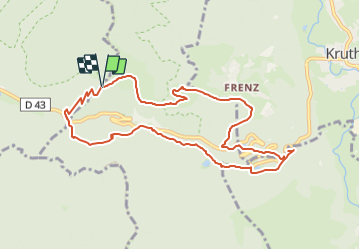
Trail Walking of 9.6 km to be discovered at Grand Est, Haut-Rhin, Fellering. This trail is proposed by Le grand Claude.

Description

longueur 9.5km avec 520m D

Elevation profile

Positioning

Country:
France
Region :
Grand Est
Department/Province :
Haut-Rhin
Municipality :
Fellering
Location:
Unknown
Start:(Dec)
Start:(UTM)
344861 ; 5310235 (32T) N.

Comments

Please log in to post a review or rate the element


gjj


Trails nearby

Trail Walking Bussang - Col de Bussang - Rouge Gazon - Séchenat - Photo
Walking
VacheKiri67

Walking

Difficult
(1)
Bussang, Grand Est, Vosges, France
15 km | 24 km-effort
6h 0min
No
Trail Snowshoes Bussang - Circuit de raquette de Bussang - Photo
Snowshoes
tracegps

Snowshoes

Difficult
(1)
Bussang, Grand Est, Vosges, France
7.7 km | 11.2 km-effort
3h 0min
Yes
Trail Walking Ventron - L'Ermitage du Frère Joseph depuis Ventron - Photo
Walking
jeanclaude12

Walking

Easy
(1)
Ventron, Grand Est, Vosges, France
10.2 km | 15.4 km-effort
2h 49min
Yes
Trail Mountain bike Bussang - activity_9407679223 - Photo
Mountain bike
GUIDE
pascalou73

Mountain bike

Medium
Bussang, Grand Est, Vosges, France
21 km | 30 km-effort
2h 2min
Yes
Trail On foot Ventron - Circuit de la Croix de l’Hermite par Forgoutte - Photo
On foot
PRO

On foot

Easy
Ventron, Grand Est, Vosges, France
4.3 km | 6.6 km-effort
1h 29min
No
Trail On foot Ventron - Circuit panoramique de la Futaie - Photo
On foot
PRO

On foot

Easy
Ventron, Grand Est, Vosges, France
8.8 km | 12.6 km-effort
2h 52min
Yes
Trail Mountain bike Bussang - Bussang_20210918_101006 - Photo
Mountain bike
GUIDE
pascalou73

Mountain bike

Very easy
Bussang, Grand Est, Vosges, France
30 km | 43 km-effort
Unknown
No
Trail Mountain bike Bussang - Bussang_20210821_100939 (1) - Photo
Mountain bike
GUIDE
pascalou73

Mountain bike

Very easy
Bussang, Grand Est, Vosges, France
31 km | 42 km-effort
Unknown
No
Trail Mountain bike Bussang - Bussang_20210717_101651 - Photo
Mountain bike
GUIDE
pascalou73

Mountain bike

Very easy
Bussang, Grand Est, Vosges, France
32 km | 44 km-effort
Unknown
Yes


Close
My subscriptions