Trail Mountain bike Moustier-Ventadour - Le chemin de la Valade - Moustier Ventadour - Pays d'Egletons  - Photo

Le chemin de la Valade - Moustier Ventadour - Pays d'Egletons

 tracegps
tracegps

User

© OpenStreetMap contributors
Length
Length
6.7 km
Max alt
Max alt
619 m
Uphill gradient
Uphill gradient
224 m
Km-Effort
Km-Effort  
9.7 km
Min alt
Min alt
456 m
Downhill gradient
Downhill gradient
224 m
Boucle
Boucle
Yes
Creation date :
2014-12-10 00:00:00.0
Updated on :
2014-12-10 00:00:00.0

(0 Reviews)

Mountain bike
Mountain bike
40m
Difficulty : Medium

Scan this QR Code to open this trail in the SityTrail application

FREE GPS app for hiking

Logo SityTrail SityTrail

IGN / Geographical institutes

Download SityTrail from the App Store Download SityTrail from Google Play

Logo SityTrail SityTrail World

The world is yours!

Download SityTrail from the App Store Download SityTrail from Google Play Download SityTrail on Huawei AppGallery

About

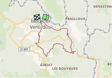
Trail Mountain bike of 6.7 km to be discovered at New Aquitaine, Corrèze, Moustier-Ventadour. This trail is proposed by tracegps.

Description

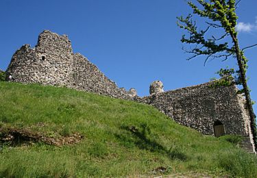
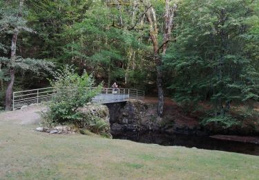
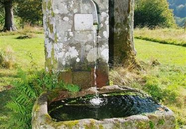
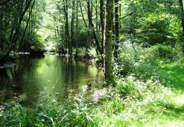
Le chemin de la Valade - Moustier Ventadour - Pays d'Egletons Cette balade autour du prestigieux château de Ventadour vous invite à suivre les pas du meunier. Du hameau de la Valade, un chemin creux, marqué par le passage des bêtes de somme, permettait d’acheminer jadis les précieux sacs de grains au moulin. Aujourd’hui restauré à l’identique, vous pourrez découvrir dans un cadre surprenant tout le mécanisme qui servait à moudre les grains. Téléchargez la fiche du circuit sur le site du Conseil Général de la Corrèze. Renseignements : Communauté de Communes de Ventadour 05.55.27.69.26
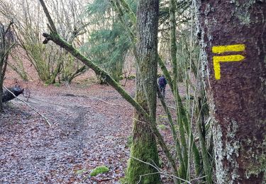
Elevation profile

Photos

Positioning

Country:
France
Region :
New Aquitaine
Department/Province :
Corrèze
Municipality :
Moustier-Ventadour
Location:
Unknown
Start:(UTM)
429895 ; 5027217 (31T) N.

Trails nearby

Trail Walking Darnets - boucle des Troubadours - Photo
Walking
viam19

Walking

Medium
(2)
Darnets, New Aquitaine, Corrèze, France
16 km | 21 km-effort
5h 26min
Yes
Trail Mountain bike Égletons - le tour d'egletons - Photo
Mountain bike
luclemoing

Mountain bike

Easy
(1)
Égletons, New Aquitaine, Corrèze, France
27 km | 34 km-effort
1h 16min
Yes
Trail Walking Moustier-Ventadour - Découverte de Moustier Ventadour - Pays d'Egletons - Photo
Walking
tracegps

Walking

Medium
(1)
Moustier-Ventadour, New Aquitaine, Corrèze, France
8.3 km | 12.2 km-effort
3h 0min
Yes
Trail Walking Lamazière-Basse - Circuit des étangs - Lamazière Basse - Pays de Haute Corrèze - Photo
Walking
tracegps

Walking

Medium
(1)
Lamazière-Basse, New Aquitaine, Corrèze, France
5.5 km | 6.8 km-effort
1h 30min
Yes
Trail Walking Moustier-Ventadour - Fred moutier ventadour - Photo
Walking
arnoultjf

Walking

Very easy
Moustier-Ventadour, New Aquitaine, Corrèze, France
8.3 km | 12.3 km-effort
2h 53min
No
Trail Walking Moustier-Ventadour - Le chemin de la Valade - Moustier Ventadour - Pays d'Egletons  - Photo
Walking
tracegps

Walking

Difficult
Moustier-Ventadour, New Aquitaine, Corrèze, France
6.7 km | 9.7 km-effort
2h 30min
Yes
Trail Walking Darnets - La Luzège aux eaux vives - Darnets - Pays d'Egletons  - Photo
Walking
tracegps

Walking

Medium
(1)
Darnets, New Aquitaine, Corrèze, France
4.1 km | 6.5 km-effort
1h 40min
Yes
Trail Walking Égletons - Egleton - Photo
Walking
famillevente@gmail.com

Walking

Medium
Égletons, New Aquitaine, Corrèze, France
6.2 km | 7.7 km-effort
1h 26min
Yes
Trail Walking Darnets - Darnets-luzège - Photo
Walking
fanclem

Walking

Difficult
Darnets, New Aquitaine, Corrèze, France
13.2 km | 16.9 km-effort
3h 50min
Yes


Close
My subscriptions