Trail Walking Saint-Sulpice-d'Excideuil - Les boucles la Caraque/le Ravillou -  Saint-Sulpice-d'Excideuil  - Photo

Les boucles la Caraque/le Ravillou - Saint-Sulpice-d'Excideuil

 tracegps
tracegps

User

© OpenStreetMap contributors
Length
Length
7.7 km
Max alt
Max alt
285 m
Uphill gradient
Uphill gradient
175 m
Km-Effort
Km-Effort  
10 km
Min alt
Min alt
205 m
Downhill gradient
Downhill gradient
171 m
Boucle
Boucle
Yes
Creation date :
2014-12-10 00:00:00.0
Updated on :
2014-12-10 00:00:00.0

(1 Reviews)

Walking
Walking
2h00
Difficulty : Medium

Scan this QR Code to open this trail in the SityTrail application

FREE GPS app for hiking

Logo SityTrail SityTrail

IGN / Geographical institutes

Download SityTrail from the App Store Download SityTrail from Google Play

Logo SityTrail SityTrail World

The world is yours!

Download SityTrail from the App Store Download SityTrail from Google Play Download SityTrail on Huawei AppGallery

About

Trail Walking of 7.7 km to be discovered at New Aquitaine, Dordogne, Saint-Sulpice-d'Excideuil. This trail is proposed by tracegps.

Description

Circuit proposé par le comité d'animation touristique et culturelle du Pays de Lanouaille. La conjugaison de ces deux sentiers donne à voir le riche patrimoine bâti et naturel de Saint-Sulpice-d’Excideuil.  Départ de l’église romane presque toujours ouverte, intéressante pour sa litre, ses fresques, ses chapiteaux…Trois-quarts d’heure pour la boucle de la Caraque sans difficulté. Entrez voir la chapelle XIXème du cimetière et ses tombes anciennes (porte nord). Si vous souhaitez marcher davantage, vous trouverez la boucle du Ravillou par la porte sud. pour voir le château de Prémilhac, apercevoir celui de La Brousse, d’Ygonie, ses pigeonniers, ses croix de carrefour etc...

Elevation profile

Photos

Positioning

Country:
France
Region :
New Aquitaine
Department/Province :
Dordogne
Municipality :
Saint-Sulpice-d'Excideuil
Location:
Unknown
Start:(UTM)
343951 ; 5028096 (31T) N.

Comments

Please log in to post a review or rate the element


très belle randonnée, très bien indiquée


Trails nearby

Trail Walking Corgnac-sur-l'Isle - Boucle de Puyfebert à Corgnac sur L'isle (24) - Photo
Walking
swp648

Walking

Very easy
(1)
Corgnac-sur-l'Isle, New Aquitaine, Dordogne, France
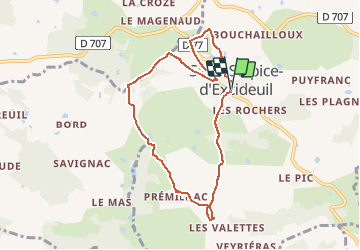
13.4 km | 16.5 km-effort
3h 27min
Yes
Trail Walking Saint-Sulpice-d'Excideuil - St Sulpice Excideuil Cavaire + Ravillou 12km - Photo
Walking
YV24

Walking

Easy
(1)
Saint-Sulpice-d'Excideuil, New Aquitaine, Dordogne, France
11.3 km | 14.4 km-effort
3h 5min
Yes
Trail Walking Nantheuil - Nantheuil route - Photo
Walking
Patricew

Walking

Easy
Nantheuil, New Aquitaine, Dordogne, France
8 km | 9.6 km-effort
1h 39min
No
Trail Walking Nantheuil - Boucle observatoire allongée Nantheuil - Photo
Walking
NICOLEROBERT

Walking

Medium
Nantheuil, New Aquitaine, Dordogne, France
11.2 km | 14.2 km-effort
2h 52min
Yes
Trail Walking Sarrazac - tacot de Nantheuil  - Photo
Walking
Patricew

Walking

Very easy
Sarrazac, New Aquitaine, Dordogne, France
7.2 km | 8.5 km-effort
1h 21min
Yes
Trail Walking Nantheuil - boucle de l'étang de es pompiers  - Photo
Walking
Patricew

Walking

Easy
Nantheuil, New Aquitaine, Dordogne, France
6.2 km | 7.3 km-effort
1h 14min
Yes
Trail Walking Nantheuil - Boucle Nantheuil Nanthiat - Photo
Walking
Alain Lacourarie

Walking

Difficult
(1)
Nantheuil, New Aquitaine, Dordogne, France
11.3 km | 14.4 km-effort
3h 18min
Yes
Trail Walking Nanthiat - le tour du Totem - Photo
Walking
Patricew

Walking

Easy
Nanthiat, New Aquitaine, Dordogne, France
7.1 km | 8.9 km-effort
1h 46min
Yes
Trail Walking Corgnac-sur-l'Isle - boucle des sans soucis - Photo
Walking
Patricew

Walking

Medium
Corgnac-sur-l'Isle, New Aquitaine, Dordogne, France
12.8 km | 15.8 km-effort
2h 44min
Yes


Close
My subscriptions