Trail Walking Vic-sur-Cère - La Grotte des Anglais - Vic sur Cère - Photo

La Grotte des Anglais - Vic sur Cère

 tracegps
tracegps

User

© OpenStreetMap contributors
Length
Length
6.3 km
Max alt
Max alt
1055 m
Uphill gradient
Uphill gradient
479 m
Km-Effort
Km-Effort  
12.8 km
Min alt
Min alt
686 m
Downhill gradient
Downhill gradient
486 m
Boucle
Boucle
Yes
Creation date :
2014-12-10 00:00:00.0
Updated on :
2014-12-10 00:00:00.0

(0 Reviews)

Walking
Walking
2h45
Difficulty : Medium

Scan this QR Code to open this trail in the SityTrail application

FREE GPS app for hiking

Logo SityTrail SityTrail

IGN / Geographical institutes

Download SityTrail from the App Store Download SityTrail from Google Play

Logo SityTrail SityTrail World

The world is yours!

Download SityTrail from the App Store Download SityTrail from Google Play Download SityTrail on Huawei AppGallery

About

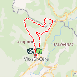
Trail Walking of 6.3 km to be discovered at Auvergne-Rhône-Alpes, Cantal, Vic-sur-Cère. This trail is proposed by tracegps.

Description

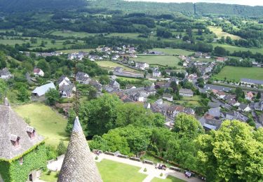
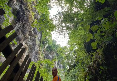
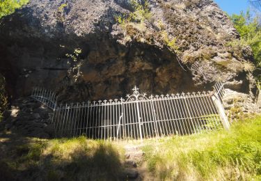
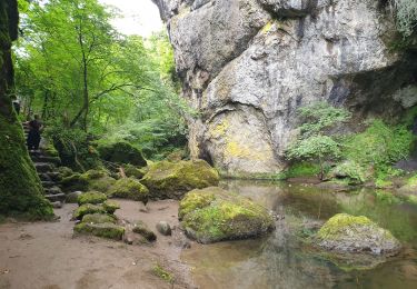
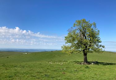
Départ : place de l'église de Vic sur Cère, prendre la rue du Cap del Lioc et suivre la direction du rocher de Maisonne. Attention, 300m de dénivelé au départ. La Grotte des Anglais est une cavité naturelle dans la roche qui aurait servi d'abri aux protestants pendant les guerres de religion. Avant d'y accéder, vous atteindrez le lieu dit "La Garde" sur le plateau du Coyan à environ 1000 m d'altitude. Chiens déconseillés, en raison des troupeaux de vaches en pâture. Cette fiche fait partie du topo guide Volcans et Vallées en Carladès.

Elevation profile

Photos

Positioning

Country:
France
Region :
Auvergne-Rhône-Alpes
Department/Province :
Cantal
Municipality :
Vic-sur-Cère
Location:
Unknown
Start:(UTM)
470326 ; 4980883 (31T) N.

Trails nearby

Trail Walking Thiézac - La Porte du Lion - Thiézac - Photo
Walking
tracegps

Walking

Medium
(2)
Thiézac, Auvergne-Rhône-Alpes, Cantal, France
6.6 km | 10.5 km-effort
3h 0min
Yes
Trail Walking Polminhac - Polminhac - Autour du donjon - Photo
Walking
tracegps

Walking

Easy
(1)
Polminhac, Auvergne-Rhône-Alpes, Cantal, France
5.2 km | 8.6 km-effort
2h 0min
Yes
Trail Walking Lascelle - Roman de Jordanne - Photo
Walking
zoe.vienne

Walking

Medium
(1)
Lascelle, Auvergne-Rhône-Alpes, Cantal, France
17.7 km | 27 km-effort
5h 54min
Yes
Trail Walking Thiézac - La porte du Lion - Thiézac - Photo
Walking
tracegps

Walking

Medium
(2)
Thiézac, Auvergne-Rhône-Alpes, Cantal, France
7.6 km | 11.5 km-effort
3h 30min
Yes
Trail Walking Pailherols - Pailherols chapelle du Cantal  - Photo
Walking
GUIDE
antignacs

Walking

Medium
Pailherols, Auvergne-Rhône-Alpes, Cantal, France
21 km | 29 km-effort
5h 29min
Yes
Trail Walking Vic-sur-Cère - Pas de Cère- cascade de Gourdole - Photo
Walking
crocau

Walking

Very easy
Vic-sur-Cère, Auvergne-Rhône-Alpes, Cantal, France
4.7 km | 6.6 km-effort
2h 0min
Yes
Trail Walking Thiézac - Puy de la poche  - Photo
Walking
nadd73

Walking

Easy
Thiézac, Auvergne-Rhône-Alpes, Cantal, France
13.1 km | 23 km-effort
3h 14min
Yes
Trail Walking Thiézac - Les Gorges du Pas de Cère - Photo
Walking
VacheKiri67

Walking

Easy
Thiézac, Auvergne-Rhône-Alpes, Cantal, France
4.8 km | 6.8 km-effort
2h 21min
Yes
Trail Walking Lascelle - Arbre de quenouille, rocher saint curial, col de berganti - Photo
Walking
impradine

Walking

Easy
Lascelle, Auvergne-Rhône-Alpes, Cantal, France
12.8 km | 19 km-effort
3h 37min
Yes


Close
My subscriptions