Trail Snowshoes Saulzet-le-Froid - Ski de fond près de Zanières autour du Puy de Monténard - Photo

Ski de fond près de Zanières autour du Puy de Monténard

 tracegps
tracegps

User

© OpenStreetMap contributors
Length
Length
7.4 km
Max alt
Max alt
1128 m
Uphill gradient
Uphill gradient
128 m
Km-Effort
Km-Effort  
9.1 km
Min alt
Min alt
1039 m
Downhill gradient
Downhill gradient
132 m
Boucle
Boucle
Yes
Creation date :
2014-12-10 00:00:00.0
Updated on :
2014-12-10 00:00:00.0

(0 Reviews)

Snowshoes
Snowshoes
3h00
Difficulty : Medium

Scan this QR Code to open this trail in the SityTrail application

FREE GPS app for hiking

Logo SityTrail SityTrail

IGN / Geographical institutes

Download SityTrail from the App Store Download SityTrail from Google Play

Logo SityTrail SityTrail World

The world is yours!

Download SityTrail from the App Store Download SityTrail from Google Play Download SityTrail on Huawei AppGallery

About

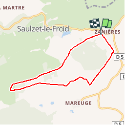
Trail Snowshoes of 7.4 km to be discovered at Auvergne-Rhône-Alpes, Puy-de-Dôme, Saulzet-le-Froid. This trail is proposed by tracegps.

Description

Un petit itinéraire qui emprunte de larges chemins mais quand la neige s'accumule et forme des congères le passage en ski de fond ou raquettes peut être "sportif", toujours agréable cependant car il suffit de prendre son temps. Je le recommande à tous ceux qui aiment la poudreuse ....par temps de brouillard il n'y a aucun problème d'orientation.

Elevation profile

Photos

Positioning

Country:
France
Region :
Auvergne-Rhône-Alpes
Department/Province :
Puy-de-Dôme
Municipality :
Saulzet-le-Froid
Location:
Unknown
Start:(UTM)
495164 ; 5054052 (31T) N.

Trails nearby

Trail Walking Le Vernet-Sainte-Marguerite - Vernet_Puy_Alou - Photo
Walking
GUIDE
jagarnier

Walking

Medium
(1)
Le Vernet-Sainte-Marguerite, Auvergne-Rhône-Alpes, Puy-de-Dôme, France
9.9 km | 13.1 km-effort
2h 50min
Yes
Trail Walking Aydat - LacAydatVeyreras_T - Photo
Walking
force

Walking

Very easy
(1)
Aydat, Auvergne-Rhône-Alpes, Puy-de-Dôme, France
11.1 km | 14.2 km-effort
3h 6min
Yes
Trail Walking Saulzet-le-Froid - Le Puy Baladou - Photo
Walking
Gegetop

Walking

Easy
(3)
Saulzet-le-Froid, Auvergne-Rhône-Alpes, Puy-de-Dôme, France
12.5 km | 17.3 km-effort
2h 54min
Yes
Trail Walking Aydat - puy de Vichatel - Photo
Walking
bernardeau

Walking

Very easy
(1)
Aydat, Auvergne-Rhône-Alpes, Puy-de-Dôme, France
3.8 km | 5.8 km-effort
1h 13min
Yes
Trail On foot Le Vernet-Sainte-Marguerite - Le Puy d'Alou - Photo
On foot
PRO

On foot

Easy
Le Vernet-Sainte-Marguerite, Auvergne-Rhône-Alpes, Puy-de-Dôme, France
9.3 km | 12 km-effort
2h 43min
Yes
Trail Walking Le Vernet-Sainte-Marguerite - Autour du Puy d’Alou - Photo
Walking
Dalma Chuck

Walking

Medium
Le Vernet-Sainte-Marguerite, Auvergne-Rhône-Alpes, Puy-de-Dôme, France
5.6 km | 7 km-effort
1h 11min
Yes
Trail Walking Le Vernet-Sainte-Marguerite - Le Puy d’Alou - Photo
Walking
Dalma Chuck

Walking

Medium
Le Vernet-Sainte-Marguerite, Auvergne-Rhône-Alpes, Puy-de-Dôme, France
6.1 km | 8 km-effort
1h 15min
Yes
Trail Walking Aurières - Auriere_Gorce_Sioule - Photo
Walking
GUIDE
jagarnier

Walking

Medium
(1)
Aurières, Auvergne-Rhône-Alpes, Puy-de-Dôme, France
14.4 km | 19 km-effort
4h 15min
Yes
Trail Walking Saulzet-le-Froid - Saulzet_Froid_Vallon_Ribeyre - Photo
Walking
GUIDE
jagarnier

Walking

Medium
Saulzet-le-Froid, Auvergne-Rhône-Alpes, Puy-de-Dôme, France
14.6 km | 17.8 km-effort
4h 15min
Yes


Close
My subscriptions