Trail Mountain bike Toulouse - De Toulouse à Plaisance du Touch - Photo

De Toulouse à Plaisance du Touch

 tracegps
tracegps

User

© OpenStreetMap contributors
Length
Length
51 km
Max alt
Max alt
205 m
Uphill gradient
Uphill gradient
444 m
Km-Effort
Km-Effort  
56 km
Min alt
Min alt
124 m
Downhill gradient
Downhill gradient
435 m
Boucle
Boucle
No
Creation date :
2014-12-10 00:00:00.0
Updated on :
2014-12-10 00:00:00.0

(0 Reviews)

Mountain bike
Mountain bike
3h45
Difficulty : Easy

Scan this QR Code to open this trail in the SityTrail application

FREE GPS app for hiking

Logo SityTrail SityTrail

IGN / Geographical institutes

Download SityTrail from the App Store Download SityTrail from Google Play

Logo SityTrail SityTrail World

The world is yours!

Download SityTrail from the App Store Download SityTrail from Google Play Download SityTrail on Huawei AppGallery

About

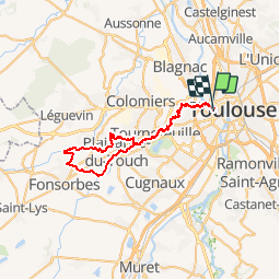
Trail Mountain bike of 51 km to be discovered at Occitania, Haute-Garonne, Toulouse. This trail is proposed by tracegps.

Description

Ce circuit emprunte le parcours de 3 itinéraires décrits sur ce site ( De la Coulée Verte du Touch à la Garonne, Le long du Touch, Tour de Plaisance du Touch). L'itinéraire part de Toulouse Saint Cyprien pour rejoindre Plaisance du Touch en suivant le cours du Touch. Puis, on fait une boucle autour de Plaisance du Touch. Un parcours très roulant avec 2 remontés faciles. La seule difficulté réside dans la longueur (52km) et la durée (3h45).

Elevation profile

Photos

Positioning

Country:
France
Region :
Occitania
Department/Province :
Haute-Garonne
Municipality :
Toulouse
Location:
Unknown
Start:(UTM)
372278 ; 4829221 (31T) N.

Trails nearby

Trail Walking Toulouse - De Toulouse à Bouconne par le GR653 - Photo
Walking
tracegps

Walking

Difficult
(1)
Toulouse, Occitania, Haute-Garonne, France
21 km | 24 km-effort
5h 0min
No
Trail Cycle Toulouse - Canal du Midi - Photo
Cycle
frizou83

Cycle

Very easy
(1)
Toulouse, Occitania, Haute-Garonne, France
259 km | 281 km-effort
15h 55min
No
Trail Walking Toulouse - Tour de Toulouse par la Garonne  - Photo
Walking
CooolGeorges

Walking

Medium
Toulouse, Occitania, Haute-Garonne, France
9.3 km | 11 km-effort
2h 35min
Yes
Trail Walking Tournefeuille - Toulouse la ramé le tour du lac - Photo
Walking

Walking

Very easy
Tournefeuille, Occitania, Haute-Garonne, France
4.7 km | 5.1 km-effort
1h 21min
Yes
Trail Walking Toulouse - Toulouse - Pinsaguel  - Photo
Walking
zazibelle

Walking

Easy
(1)
Toulouse, Occitania, Haute-Garonne, France
15.6 km | 17.5 km-effort
4h 59min
No
Trail Walking Blagnac - Blagnac, le long de la Garonne  - Photo
Walking
phil88

Walking

Easy
Blagnac, Occitania, Haute-Garonne, France
5.3 km | 5.9 km-effort
1h 48min
Yes
Trail Cycle Toulouse - Canal du Midi - Etape 1 - Photo
Cycle
frizou83

Cycle

Very easy
Toulouse, Occitania, Haute-Garonne, France
55 km | 61 km-effort
3h 28min
No
Trail Walking Toulouse - Rive Droite Garonne Toulouse Gagnac - Photo
Walking
RR31

Walking

Easy
Toulouse, Occitania, Haute-Garonne, France
24 km | 27 km-effort
5h 55min
No
Trail Walking Toulouse - Rive Droite Garonne Toulouse Gagnac - Photo
Walking
RR31

Walking

Easy
Toulouse, Occitania, Haute-Garonne, France
24 km | 27 km-effort
5h 55min
No


Close
My subscriptions