Trail Walking Thérondels - THÉRONDELS _ et le paysan créa la prairie 1) - Photo

THÉRONDELS _ et le paysan créa la prairie 1)

 Elbe
Elbe

User

© OpenStreetMap contributors
Length
Length
1.9 km
Max alt
Max alt
954 m
Uphill gradient
Uphill gradient
13 m
Km-Effort
Km-Effort  
2.1 km
Min alt
Min alt
940 m
Downhill gradient
Downhill gradient
15 m
Boucle
Boucle
Yes
Creation date :
2014-12-10 00:00:00.0
Updated on :
2014-12-10 00:00:00.0

(0 Reviews)

Walking
Walking
30m
Difficulty : Very easy

Scan this QR Code to open this trail in the SityTrail application

FREE GPS app for hiking

Logo SityTrail SityTrail

IGN / Geographical institutes

Download SityTrail from the App Store Download SityTrail from Google Play

Logo SityTrail SityTrail World

The world is yours!

Download SityTrail from the App Store Download SityTrail from Google Play Download SityTrail on Huawei AppGallery

About

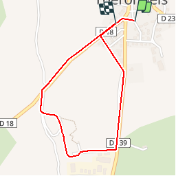
Trail Walking of 1.9 km to be discovered at Occitania, Aveyron, Thérondels. This trail is proposed by Elbe.

Description

Les Sentiers de l'Imaginaire
CARLADEZ - AVEYRON

L’âme du sentier :
Gaillarde, la vache aux yeux maquillés de noir, paît tranquillement dans les prés, faisant le lien entre la Nature et l'Homme...
Suivez le pas lent des animaux, adoptez le rythme du soleil, mettez vos pas dans les traces laissées par les paysans depuis des temps immémoriaux...

Départ : Depuis la Mairie, rejoindre la place des tilleuls. A droite de la supérette, suivre le sentier arboré de tilleuls en bordure de la route D18, en direction de Brommat..
Balisage : Pierres sculptées   vaches en bois. (tracé rouge)

Elevation profile

Positioning

Country:
France
Region :
Occitania
Department/Province :
Aveyron
Municipality :
Thérondels
Location:
Unknown
Start:(UTM)
480937 ; 4971356 (31T) N.

Trails nearby

Trail Walking Thérondels - Thérondels,Nigresserre - Photo
Walking
paul12

Walking

Easy
(1)
Thérondels, Occitania, Aveyron, France
12.7 km | 14.8 km-effort
3h 14min
No
Trail Walking Thérondels - Balade à la presqu''ile de Laussac - Thérondels - Photo
Walking
tracegps

Walking

Difficult
(1)
Thérondels, Occitania, Aveyron, France
17.1 km | 24 km-effort
6h 0min
Yes
Trail Walking Lacapelle-Barrès - puy de Bane - Photo
Walking
Jean-Marie Bousquet

Walking

Difficult
Lacapelle-Barrès, Auvergne-Rhône-Alpes, Cantal, France
19.2 km | 26 km-effort
4h 3min
Yes
Trail Walking Thérondels - Therondels  - Photo
Walking
bougnaou

Walking

Medium
Thérondels, Occitania, Aveyron, France
15.9 km | 22 km-effort
3h 14min
Yes
Trail Other activity Thérondels - Therondels à Pierrefort - Photo
Other activity
paul12

Other activity

Medium
Thérondels, Occitania, Aveyron, France
12.3 km | 17.6 km-effort
4h 21min
No
Trail Walking Paulhenc - tersons 13b - Photo
Walking
catherineslater

Walking

Very easy
Paulhenc, Auvergne-Rhône-Alpes, Cantal, France
11.4 km | 13.7 km-effort
3h 9min
No
Trail Walking Thérondels - THÉRONDELS _ et le paysan créa la prairie 2) - Photo
Walking
Elbe

Walking

Very easy
(1)
Thérondels, Occitania, Aveyron, France
4.1 km | 4.8 km-effort
1h 30min
Yes
Trail Walking Thérondels - Sentier imaginaire court Therondels  - Photo
Walking
Danielfontange

Walking

Easy
Thérondels, Occitania, Aveyron, France
3.6 km | 3.9 km-effort
1h 11min
Yes
Trail Walking Cantoin - Vines les berges du lac de Sarrans - Photo
Walking
les joyeux randonneurs

Walking

Difficult
Cantoin, Occitania, Aveyron, France
11.2 km | 16.4 km-effort
3h 43min
Yes


Close
My subscriptions